Warm Temperatures this Week. A Chance for Rain Thursday into Early Friday
March 4, 2024
We’re looking at warm, spring-like weather across the region this week. There will be a two opportunities for rain and scattered thunderstorms, but total rain amounts are expected to be low—around a quarter inch or less.
The first opportunity for rain is predicted for late Monday afternoon and Monday evening when a weak wave of low pressure tracks into South Texas out of northern Mexico. Although plenty of low-level moisture is in place, a capping stable layer in the lower atmosphere is expected to keep the development of showers and thunderstorms to a minimum. The most favorable area for rain development is expected to be for areas located south of Interstate 10. Here, the chance for rain through late evening will be near 30 percent. For the rest of the region, then chance for rain will only be near 20 percent.
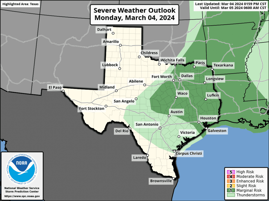
Should any thunderstorms happen to develop this afternoon and evening, there will be a slight chance some of the storms could become severe. The Strom Prediction Center has placed the northern Hill Country and the northern counties of Central Texas under a Marginal Risk (a 1 out of 5 risk) for severe thunderstorms through Monday evening.
Rain amounts, if any, are forecast to average less than a quarter inch. Monday’s weather will be partly to mostly and warm with high temperatures around 80-82 degrees. The chance for rain will diminish late Monday evening when the trough of low pressure exits to the east.
Tuesday’s weather will feature widespread low clouds and patchy fog for areas along and east of Interstate 35 through about mid-morning. A sunny sky is forecast late morning through afternoon. Tuesday is shaping up to be the warmest day of the week for the Hill Country and Interstate 35 corridor as the dry line pushes east, bringing in drier and warmer air. High temperatures here are predicted to be close to 90 degrees! For the rest of the region, expect high temperatures in the mid-80s.
Wednesday’s weather is predicted to be partly cloudy and warm. A weak cold front is forecast to sink south across the area Wednesday morning and stall close to Interstate 10 Wednesday afternoon. No rain is forecast with the cold front. High temperatures Wednesday will include the upper 70s across the northern Hill Country and the low 80s at most other locations.
A period of somewhat unsettled weather is forecast to unfold beginning late Wednesday night when a couple of waves of low pressure push east out of the Desert Southwest. As these two waves of low pressure move into Texas, they may spark the development of scattered showers and thunderstorms across the region beginning late Wednesday night, continuing Thursday and Thursday night. There are early indication some of the thunderstorms may be strong to severe—mainly across the northern half of the region (including the Austin metro). The probability for rain Thursday and Thursday night will be near 40-50 percent. A chance for rain is forecast to continue Friday morning, with the chance for rain then diminishing from west to east behind a Canadian cold front.
Rain amounts Thursday through Friday morning are forecast to average less than a quarter inch across the Hill Country, and between a quarter and a half inch at most other locations.
The front is expect to cause breezy north winds of 10-20 mph with occasional higher gusts Friday afternoon through Saturday afternoon. The gusty winds should diminish Saturday night. The sky looks to clear Friday afternoon, with mostly sunny and cooler weather forecast for the weekend.
- High temperatures Friday are forecast to be in the mid and upper 70s.
- Lows Saturday morning will include the low and mid-40s across the Hill Country, the mid and upper 40s across Central Texas, with low 50s across the coastal plains.
- High temperatures Saturday and Sunday are forecast to be in the mid and upper 60s.
- Lows Sunday morning will range from the upper 30s to 40 degrees across the Hill Country, to the mid-40s across the coastal plains.
Next Week
Dry and mild weather is forecast the first half of next week. High temperatures in the low 70s Monday, should warm to the upper 70s by Wednesday. Lows will be in the 50s.
Forecasts point to a slight chance to chance for scattered rain showers next Thursday through Saturday as a trough of low pressure sinks southeast out of the southern Rockies. Rain amounts of 0.25 to 0.5 inches are currently forecast. High temperatures late week are forecast to be in the 70s, with lows in the 50s.
Time Change Weekend is Coming Up
Daylight saving time will begin for 2024 on Sunday, March 10th at 2 am local time. At that time, our clocks will “spring forward” one hour. Sunrise and sunset will be about 1 hour later on Mar 10, 2024 than the day before.
Bob
Social Media