Unseasonably warm and humid conditions continue in place as we close out the week and the year. However, big changes in the weather are definitely on the horizon. Widespread clouds and areas of fog Friday morning should give way to a partly cloudy sky and warm temperatures in the afternoon. Friday’s readings look to peak at around 78-80 degrees.
There will be a slight chance for scattered rain showers and isolated thunderstorms across the Edwards Plateau and the northern Hill between late Friday evening and daybreak Saturday when a trough of low pressure tracks northeast across West Texas out of northern Mexico. There will be a low chance for some of these thunderstorms to become strong to severe. The Storm Prediction Center has placed North Texas, generally north of a line stretching from Abilene to Texarkana under a Marginal Risk for severe thunderstorms. The primary severe weather threat is expected to be large hail. Further south across the eastern Hill Country, Central Texas and the middle Texas coast, no rain is forecast overnight. Expect a cloudy sky with warm temperatures. Readings at midnight are forecast to be near 70 degrees. Lows Saturday morning are forecast to range from the mid-60s west, to around 70-72 degrees near the coast.
For New Year’s Day, widespread clouds are expected in the morning, to be followed by mostly sunny conditions in the afternoon. It will be another unseasonably warm day, with high temperatures forecast to be around 80-82 degrees. Expect a westerly wind at 10-15mph, with gusts to 25 mph.
The recent stretch of spring-like weather will come to an abrupt end Saturday night when an arctic cold front blasts south across Texas. The stagnant jet stream pattern we’ve seem for the past couple of weeks is finally changing and allowing very chilly air to spread to the south. The arctic cold front is forecast to reach the northern Hill Country around sunset on Saturday, the Austin area around 9/10 pm and the coastal plains region shortly after midnight. No rain is forecast along or behind the cold front.
Get ready for the cold! Windy conditions and much colder temperatures will follow the cold front Saturday night through Sunday afternoon. Expect northerly winds at 15-25 mph with gusts to 30 mph. The temperature is forecast to fall below freezing across the Hill Country and all of Central Texas south to roughly Interstate 10 Sunday morning. The temperature will struggle warming into the 40s on Sunday. The wind is predicted to decrease Sunday night, setting the stage for a region-wide freeze and the coldest night so far this winter.
Everyone should prepare now for a hard freeze and make the necessary cold weather precautions which include the four Ps: protect Plants, Pipes, Pets, and People, particularly those who are elderly or have comprised health). In addition, make sure outdoor faucets are covered and sprinklers are turned OFF (as they can produce dangerous ice on sidewalks and streets, possibly causing slips and injuries).
- Lows Sunday morning are forecast to be in the low and mid-20s across the Hill Country, the mid and upper 20s across Central Texas and the mid-30s across the coastal plains region.
- High temperatures Sunday are predicted to only reach the mid and upper 40s. Wind chill readings are forecast to be in the mid-teens to mid-20s Sunday afternoon.
- Low temperatures Monday morning are predicted to be in the upper teens to low 20s across the Hill Country, the low and mid-20s across Central Texas and around 28-30 degrees across the coastal plains region.
Sunny and warmer weather is forecast Monday through Wednesday as the arctic air mass begins moving off to the east.
- Lows Tuesday morning will include the low 30s across the Hill Country, the mid-30s across Central Texas, and near 38-40 degrees across the coastal plains.
- High temperatures Tuesday are predicted to be near 68-70 degrees.
- Low temperatures Wednesday morning are forecast to be near 40 degrees across the Hill Country and in the mid to upper 40s at most other locations.
- High temperatures Wednesday are predicted to near 70-72 degrees.
- Low temperatures Thursday morning are forecast to be in the low and mid-40s across the Hill Country and Central Texas regions and in the mid-50s across the coastal plains.
Forecasts call for another strong cold front to push south across our region next Thursday, bringing a quick shot of colder air Thursday night into Friday, followed by milder temperatures next weekend. No rain is expected with the front.
- Thursday’s temperature in the 60s is forecast to fall into the 50s in the afternoon.
- Lows Friday morning will include the upper 20s across the Hill Country, the low 30s across Central Texas and the upper 30s across the coastal plains.
- High temperatures Friday are forecast to be in the mid and upper 50s.
- Lows Saturday morning are forecast to be in the 40s to low 50s.
Mostly sunny conditions are forecast next weekend, with high temperatures expected to be in the 60s to near 70 degrees.
No significant rain is predicted between now and next Sunday. However, long-range forecasts do call for a chance for rain to develop around January 11th and 12th.
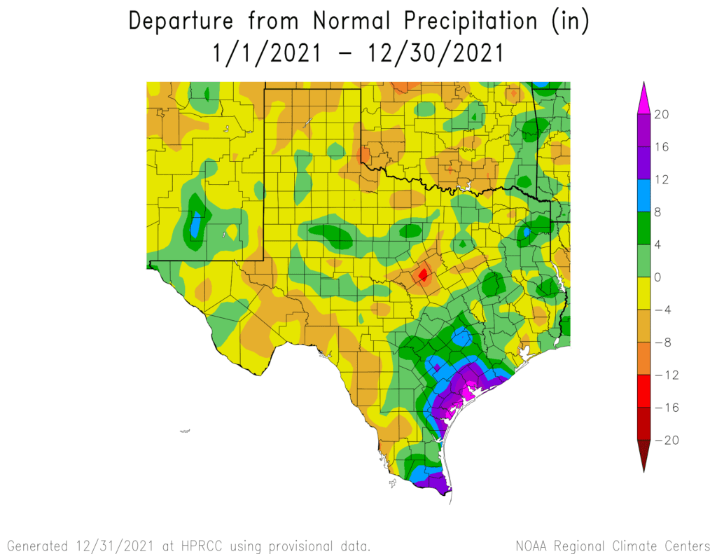
2021 Ending Wetter Than-Normal Central Texas and Coastal Plains
Wetter than-normal conditions late spring through summer along with spotty rains in the fall helped push 2021’s rain totals above normal across Central Texas and the middle Texas coast. Rain amounts across the Hill Country were less exuberant, leading annual totals to be near-normal, or a couple of inches below normal.
The following National Weather Service chart shows the rainfall departure from-normal for 2021. Note departures from-normal over more than 16 inches across parts of Wharton and Matagorda Counties.
Lots of exciting weather is ahead of us in 2022 and winter is just getting started.
Wishing everyone a Safe and Happy New Year!
Bob
Social Media