Hurricane Hanna made landfall Saturday afternoon as a category one hurricane along the lower Texas coast, at the Padre Island National Seashore, about 50 miles south of Corpus Christi. Highest sustained winds at landfall were 90 mph. A wind gust to 68 mph was measured at Corpus Christi and gust to 81 mph was measured at Baffin Bay Padre Island. Interestingly, Austin-Bergstrom Airport recorded a wind gust to 59 mph Saturday afternoon when a thunderstorm associated with the hurricane passed over the airport. Hanna produced torrential rains of 10-15 inches across the Lower Rio Grande Valley and adjacent areas of northeastern Mexico. As of Monday morning, Hanna was still designated as a tropical depression and was located over northeastern Mexico, to the southwest of Monterey. The system was moving to the west at 5 mph and is predicted to bring additional heavy rain to northern Mexico and the Rio Grande Valley this afternoon and Tuesday.
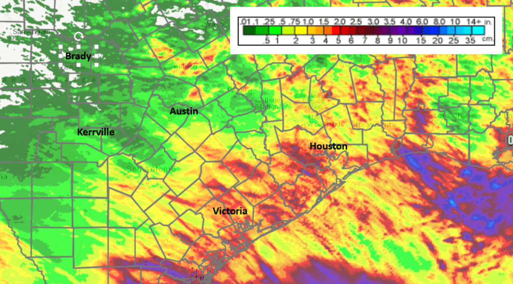
Across Central Texas, the Hill Country and the middle Texas coast, rainfall from Hanna ended up being much lower than was originally forecast. Doppler radar estimates and gauge reports showed most totals since Friday were generally less than a quarter inch across the Hill Country. Across Central Texas, totals ranged anywhere from a tenth of an inch to 1.5 inches. And across the coastal plains region, totals generally ranged between 1 and 2.5 inches. LCRA’s highest 72-hour gauge total was 3.65 inches near Garwood, in southeastern Colorado County.
NWS Radar Estimate of Rain Falling Between 7 am Friday and 7 am Monday:
Monday’s analysis indicated the atmosphere over Central Texas was still quite moist in the wake of Hanna. In the upper atmosphere, a weak ridge of high pressure was located over Far West Texas and the Desert Southwest. A small area of low pressure was in place over western Louisiana, drifting to the southwest. Circulation around the low is forecast to pull additional tropical moisture into Central Texas this afternoon through Wednesday. With warming afternoon temperatures, scattered rain showers and thunderstorms are predicted to develop across the entire region. The highest probability for showers will be across the coastal region, where the probability for rain will be near 60 percent this afternoon and Tuesday and near 40 percent Wednesday. Across Central Texas, the probability for rain will be near 30 percent this afternoon and Tuesday and just 20 percent Wednesday. The probability for rain across the Hill Country will be 20 percent all 3 days.
Rain amounts through Thursday morning are forecast to average between 0.5 and 0.75 inches across the coastal plains region and around a quarter inch or less across Central Texas and the Hill Country.
High temperatures Monday through Wednesday are forecast to generally be in the mid and upper 90s. Highs near 90-92 degrees are predicted for the coast region.
Mostly sunny and generally dry weather is forecast across the region Thursday and Friday as moisture levels decrease. Lingering moisture may cause a few stray showers across the coastal plains region, but most other locations should stay dry. High temperatures Thursday and Friday will be in the upper 90s.
A slightly unsettled weather pattern is forecast to develop across our region this weekend, continuing through the first half of next week, when an unusually strong trough of low pressure develops south from southern Canada to the lower Mississippi River Valley. At the same time, the ridge of high of high pressure over West Texas is predicted to slide west to western Arizona and Northwestern Mexico. A cold front associated with the trough is predicted to sink south to North Texas and pull up stationary. The combination of a weaker ridge and the proximity of the stalled front to our north is expected to cause a slight chance to a chance for scattered rain showers and thunderstorms each day between Saturday and next Wednesday. As of now, significant rain is not forecast, with most totals over this upcoming period remaining below 1 inch. High temperatures will be mostly in the mid and upper 90s.
Mostly sunny, dry and slightly warmer weather is forecast late next week into the following weekend as the trough weakens and the ridge to our west moves to a position over New Mexico. High temperatures are predicted to be in the upper 90s to 100 degrees.
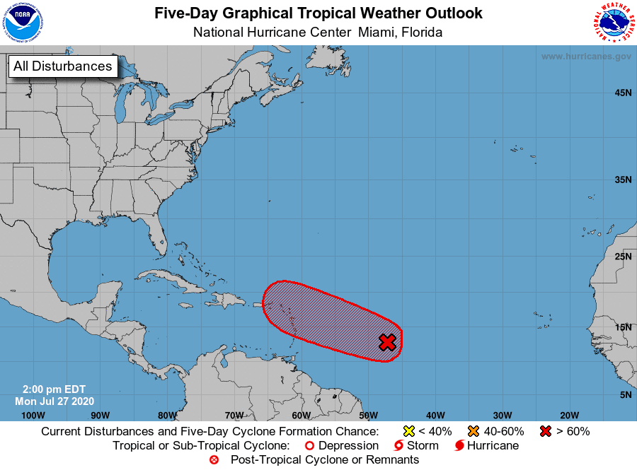
Tropical Weather Outlook
Tropical Storm Gonzalo weakened into an open wave of low pressure when in entered the eastern Caribbean Sea Saturday. Conditions remain unfavorable for this system to regenerate.
National Hurricane Center forecasters continue to closely monitor a broad area of low pressure located 1000 miles east of the Windward Islands. Shower activity associated with this feature has changed little in organization since this morning. Environmental conditions are expected to become somewhat more favorable for development during the next few days and a tropical depression or tropical storm is likely to form during that time frame. The system is forecast to move westward to west-northwestward at 15 to 20 mph and it could bring heavy rain to portions of the Leeward Islands by late Wednesday, regardless of development. NHC forecasters are giving this system an 80 percent chance for development over the next 5 days.
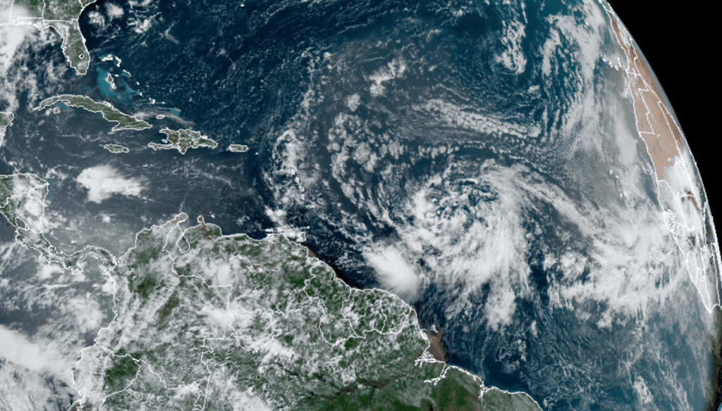
RAMMB-CIRA 07/27/2020 12:40 pm CDT
Elsewhere, there are no systems in place which pose a threat for tropical development over the next 5 days.
One of the Hottest July’s on Record
As we move into the last few days of July, data so far this month shows July 2020 will likely close as one of the hottest on record across Central Texas. While most areas have seen several triple-digit temperatures this month, the unusually warm nighttime temperatures have also been a big part of the very warm monthly average temperature.
At Austin-Camp Mabry, the average temperature through Sunday (7/26) was 89.0 degrees, 4.2 degrees above normal. July 2020 currently ranks as the 3rd warmest July on record, behind similar periods in 2011 and 2009. Not exactly the “coolest” of summers to be keeping company with.
Have a good week.
Bob
Social Media