The month of June will be closing as one of the hottest Junes on record, with the temperature averaging between 2 and 4 degrees above normal! An unusually early and strong heat dome set up across Texas just after the beginning of the month, leading to numerous days of record to near-record heat across most of the state. Over the past couple of days, the heat dome has slowly shifted off to the east, and as of Friday morning, it was centered over the lower Mississippi Valley. Forecast solutions call for the center of the ridge to weaken and remain east of our region through late next week. Unfortunately, this break from the ridge will be somewhat short-lived as forecasts call for a new heat ridge to develop and gain strength over the Desert Southwest late next week. This new ridge is forecast to spread into West Texas the week of July 10th.
With the ridge center now east of our region, slightly lower temperatures can be expected this weekend and all of next week.
- High temperatures Friday and Saturday are forecast to be near 98-100 degrees across the Hill Country and Central Texas regions, and in the upper 90s across the coastal plains.
- High temperature Sunday through Wednesday are forecast to be in the upper 90s across the Hill Country and Central Texas regions, and in the mid to upper 90s across the coastal plains.
- High temperatures Thursday and Friday are forecast to be in the mid and upper 90s across the Hill Country and Central Texas, and in the low to mid-90s across the coastal plains.
- High temperatures next weekend are forecast to be back to 98-100 degrees.
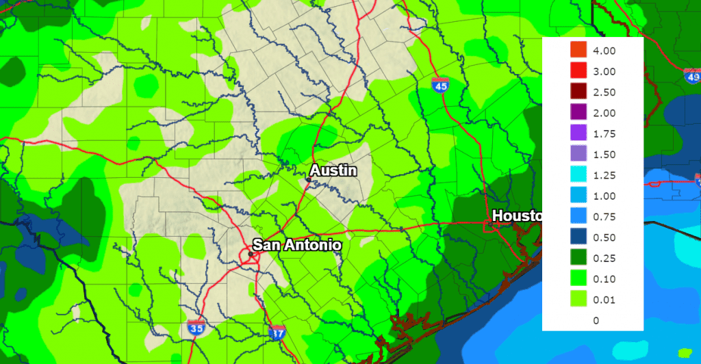
Another benefit to the ridge being off to the east is that it will allow for the atmosphere over our area to become a bit less stable. Forecasts call for a weak trough of low pressure to settle south to the southern Plains late this weekend and remain over this general area through late next week. The trough is expected to pull an area of moisture north from the Gulf of Mexico into Southeast Texas beginning early next week. This will result in a 20-30 percent chance for scattered rain showers and isolated thunderstorms across the middle and upper Texas coastal regions Tuesday and Wednesday. Rain amounts, if any, should total less than a quarter inch. No rain is forecast across the Hill Country or Central Texas.
Forecasts call for slight chance to a chance for rain showers to develop across the entire region next Thursday into Friday when a second trough of low pressure dips south into the Red River Valley, pulling moisture further to the north and west. Forecasts call for a 20-30 chance for scattered rain showers and isolated thunderstorms across the region both days. Totals through Friday are forecast to only average around a quarter inch, with a few isolated heavier totals.
NWS Rainfall Forecast for the Period 7 pm Friday through 7 pm Next Friday:
A dry weather pattern looks to resume next weekend and continue into the following week.
The outlook for the week of July 10th calls for sunny and very hot weather, with a return of triple-digit temperatures. Expect maximum readings near 100-102 degrees.
Tropical Weather Outlook
Weather conditions are quiet across the tropical Atlantic, the Caribbean Sea, and the Gulf of Mexico.
National Hurricane Center forecasters are monitoring a disorganized area of showers and thunderstorms located a couple of hundred miles to the southeast of Bermuda. This activity is associated with a broad area of low pressure. However, strong upper-level winds do not appear conducive for this system to develop into a tropical or subtropical cyclone while it moves generally north-northeastward at about 10 mph during the next couple of days. This system poses no threat to the Gulf of Mexico region. NHC forecasters are giving this system a low chance, just a 10 percent chance for topical development over the next 7 days.
Latest Sunset and the Full Buck Moon
The latest sunset of the year will take place Friday and Saturday evenings. In Austin, sunset both days will be at 8:36 pm. Enjoy these bright, long days.
The July full moon will occur on Monday, July 3rd, at 6:39 am CDT. However, the moon will still appear full Sunday and nights to the casual stargazer. July’s full moon is often known as the Buck Moon or Thunder Moon. Traditionally, the full moon in July is called the Buck Moon because a buck’s antlers are in full growth mode at this time, according to the Old Farmer’s Almanac. The July full moon is also known as the Thunder Moon because thunderstorms are so frequent during this July across the Midwest and the Northeastern US.
Have a great weekend!
Bob
Social Media