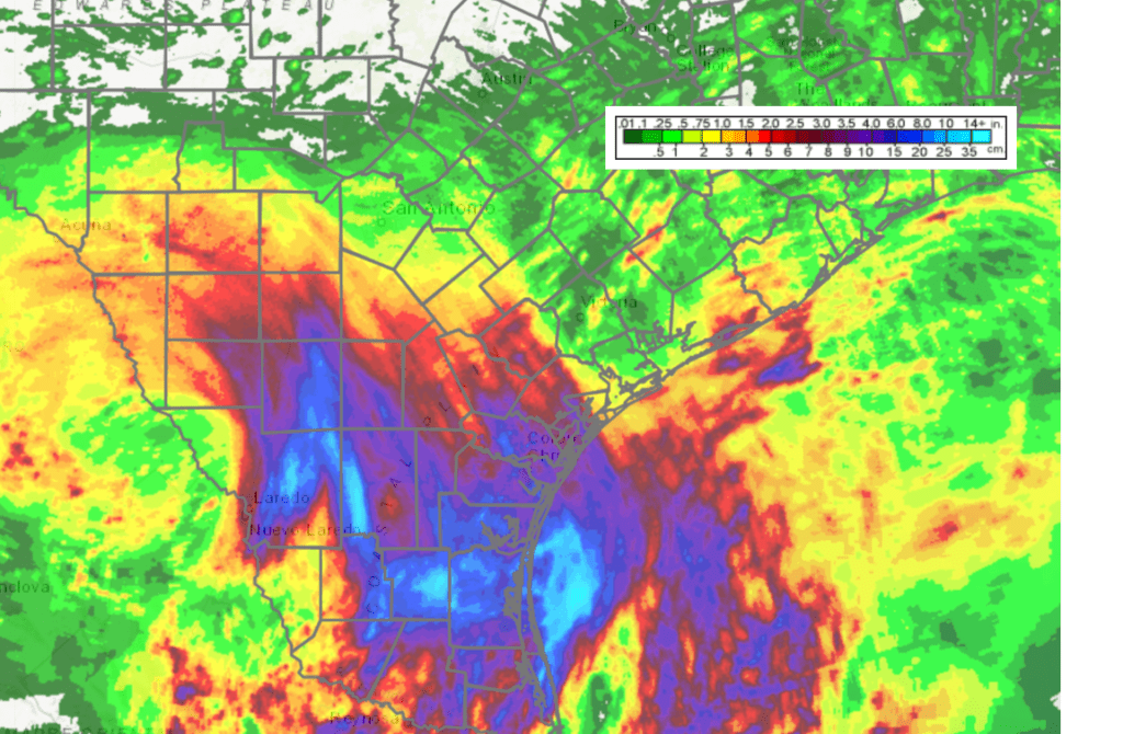
Spotty showers developed across parts of the region over the weekend as an area of low pressure over the Gulf of Mexico tracked onshore along the lower Texas coast. According to LCRA’s Hydromet, rain totals since Friday averaged between a few hundredths of an inch and a half inch across parts of Central Texas and the coastal plains region. LCRA’s gauge located along the coast near Matagorda was the big winner, with a 3-day total of 2.8 inches! The heaviest rains associated with the low pressure system fell to the south of San Antonio and Victoria. Clouds from the low pressure system kept temperatures below 100 degrees across the region on Sunday. In fact, Sunday was the “coolest” day our region has seen since late June.
NWS Estimate of Rain Falling Between 1 pm Friday and 1 pm Monday:
As of early Monday afternoon, the low pressure area was located over northeastern Mexico, just to the west of Eagle Pass. Doppler radar showed widespread light to moderate rain associated with the low falling across South Texas, generally to west of a line stretching from Del Rio, to Bandera, to Alice. The low is forecast to track northwest across Far West Texas Tuesday, then move into New Mexico on Wednesday. Unfortunately, the low and its associated moisture is predicted to stay too far to the west to bring any rain to the Hill Country or Central Texas regions. There will be a slight chance for a few scattered rain showers across the middle Texas coast this afternoon due to lingering tropical moisture and the Sea Breeze. However, significant rain is not expected.
Afternoon satellite images showed scattered clouds associated with the outer circulation of the low covering the Hill Country and the southern half of the state. These clouds will cause a partly cloudy to mostly sunny sky this afternoon. High temperatures will include the middle 90s across the Hill Country and coastal regions, and the upper 90s to 100 degrees across Central Texas.
Mostly sunny, dry and hot weather is forecast Tuesday through Wednesday as the heat dome/high pressure ridge strengthens across Texas. This may actually be the heat dome’s last hurrah for a little while.
- High temperatures both days will include the upper 90s to 100 degrees across the Hill Country and coastal regions, and near 100-103 degrees across Central Texas.
A change in the weather pattern is forecast to take place late this week as the heat dome/ridge of high pressure over Texas weakens and shifts to the western U.S. At the same time, a large trough of low pressure over the Great Lakes region is forecast to build south to the lower Mississippi Valley. The developing trough will help push a rare August cold front into Texas Thursday. Forecasts call for the cold front to reach Central Texas Thursday afternoon and the middle Texas coast Thursday evening. The front is predicted to pull up stationary over South Texas Friday through Saturday.
A fairly widespread area of rain showers and scattered thunderstorms is forecast to develop along and behind the cold front as it sinks to the south during the day Thursday. The probability for rain will be near 40-50 percent across the region, with rain amounts generally averaging between 0.25 and 0.5 inches. High temperatures Thursday are forecast to be in the mid-90s across the Hill Country, with upper 90s expected across Central Texas and the middle Texas coast.
Friday’s forecast calls for a partly cloudy sky with a 30 percent chance for mainly afternoon scattered rain showers and thunderstorms. Friday’s totals are predicted to average around a quarter inch, or less. Expect a partly cloudy sky with high temperatures generally in the mid-90s.
Saturday’s outlook calls for a mostly sunny sky with just a slight chance (a 20 percent chance) for scattered afternoon showers and thunderstorms. Otherwise, expect a mostly sunny sky with a high temperature in the mid and upper 90s.
Sunday into Monday, a slight chance for scattered rain showers and thunderstorms will continue across the Hill Country and Central Texas regions, while a somewhat better chance for rain is expected towards the coast. This chance for rain is due to a weak, non-tropical low pressure area moving into South Texas out of the Gulf of Mexico. High temperatures both days are predicted to be in the mid and upper 90s across the Hill Country and Central Texas regions.
The outlook for next week calls for the weather pattern to remain somewhat unsettled. Forecasts call for the ridge to remain over the western U.S., while a trough of low pressure will continue across the Plains and the eastern U.S. There are signs another cold front will sink south into Texas around the middle of next week. Some periods of showers and thunderstorms are expected throughout the weekend. High temperatures are forecast to stay mostly in the mid and upper 90s.
Tropical Weather Outlook
Weather conditions are quiet across the tropical Atlantic, the Caribbean Sea and the Gulf of Mexico. Tropical cyclone development is not expected over the next five days,
Have a good week.
Bob
Social Media