It’s been a hot week across the area, with temperatures each day reaching the mid and upper 90s. The only rain to speak of has fallen across the coastal plains region, where totals have averaged close to a third of an inch or less. Factoring in the high humidity, it’s felt very much like August. Few changes in the pattern are expected this afternoon as high temperatures should again reach the mid and upper 90s.
But some changes to the August pattern are expected to take place this weekend as the persistent ridge of high pressure, or heat dome, weakens and begins to shift off to the west. At the same time, a large trough of low pressure is forecast to develop from the Great Lakes region south to the southern Plains and the middle Mississippi Valley. This trough will help push a weak cold front south, with the front stalling somewhere near or just south of the Red River by Monday.
Saturday’s weather is shaping up to be mostly sunny and continued hot. However, there will be a 20-30 percent chance for scatted rain showers and thunderstorms across the region in the afternoon and evening hours. Forecasts call for scattered thunderstorms to develop across parts of North and Northeast Texas Saturday afternoon, with some of the activity spreading south into the Hill Country and Central Texas in the late afternoon and evening. The rain and storms should diminish Saturday evening. Rain amounts are forecast to average around a quarter inch, with isolated heavier totals. High temperatures Saturday will again be in the mid and upper 90s.
The most favorable period for rain showers and thunderstorms is expected to occur Sunday into Sunday evening when weak disturbances rotate south into Texas from the large trough over the Plains states. Rain showers and scattered thunderstorms are forecast to develop across the region by afternoon, with the activity continuing into the evening hours. The probability for rain and storms is predicted to be near 50 percent. Rain amounts are forecast to average between a quarter and a half inch, with isolated totals of 1-2 inches possible. Expect a partly to mostly cloudy sky with high temperatures in the low to mid-90s.
A slight chance for scattered, mainly afternoon and evening showers and thunderstorms is forecast Monday and Tuesday as additional weak disturbances track south into Central and South Texas. The probability for rain will be near 30 percent Monday, decreasing to 20 percent Tuesday. Daily rain amounts are predicted to average around a quarter inch, with isolated heavier totals. High temperatures both days are forecast to be in the mid-90s.
A mostly sunny and hot weather pattern is forecast to resume next Wednesday as the trough weakens and a ridge of high pressure begins to spread over Texas out of the Gulf of Mexico. These sunny and hot conditions look to continue late week and through next weekend. High temperatures through the period are forecast to be in the mid and upper 90s, with low to mid-90s expected towards the coast.
Looking out into the week of August 23rd, forecasts are calling for a slight chance for rain early in the week as a weak cold front sinks south into our area. Otherwise, typical August weather should continue with high temperatures remaining in the mid and upper 90s.
We’ve now made it past the hump of summer! According to historical averages, the hottest average temperatures of summer occur between roughly August 2nd and August 11th. Average temperatures are now on a slow fall through the end of the month. In fact, the average temperature on August 31st is about 2.5 degrees lower than it is today. While summer is far from over, the hottest point of summer is hopefully now in our rearview mirror.
Tropical Weather Outlook
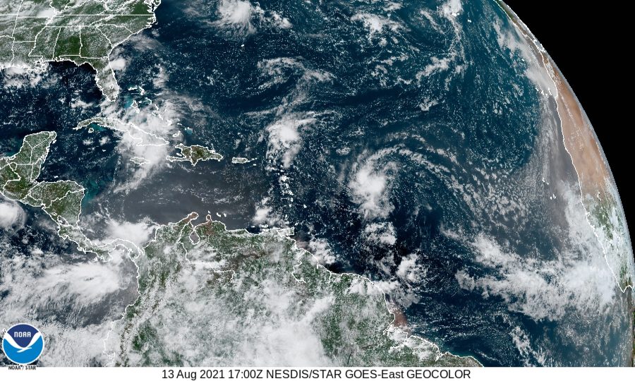
National Hurricane Center forecasters are closely monitoring Tropical Depression Fred located near the north-central coast of Cuba, and Potential Tropical Cyclone Seven, located about 850 miles east of the Lesser Antilles. Neither one of these systems is expected to threaten the western Gulf of Mexico. A strong tropical wave is forecast to move off the coast of Africa sometime early next week.
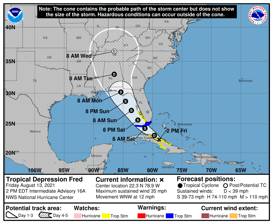
Tropical Depression Fred at 1 pm CDT was centered about 245 miles southeast of Key West, Florida. The depression was moving toward the west-northwest near 12 mph, and this general motion is expected to continue today. A turn toward the northwest is expected tonight or Saturday. On the
forecast track, Fred is expected to move along or near the north coast of central Cuba through tonight, be near the Florida Keys on Saturday, and move near or west of the west coast of the Florida peninsula Saturday night and Sunday. Maximum sustained winds were near 35 mph with higher gusts. Little change in strength is expected today. After that, slow strengthening is expected, and Fred could become a tropical storm again tonight or Saturday.
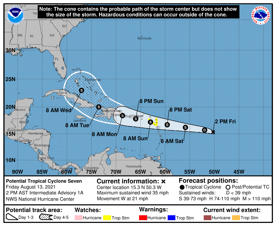
A strong tropical wave located over the central tropical Atlantic is expected to become a tropical storm by Saturday and has been declared Potential Tropical Cyclone Seven by the National Hurricane Center.
As of 1 pm CDT, the center of Potential Tropical Cyclone Seven was located about 775 miles east of the Leeward Islands. The system is moving toward the west near 21 mph, and this general motion with a gradual decrease in forward speed is expected into early next week. On the forecast track, the system is expected to approach the Leeward Islands on Saturday, move over the Leeward Islands Saturday night and Sunday, and be near the Virgin Islands and Puerto Rico Sunday night and Monday. Maximum sustained winds are currently near 35 mph with higher gusts. Gradual strengthening is forecast during the next couple of days, and the disturbance is expected to become a tropical depression Friday night and a tropical storm by Saturday.
Have a good weekend.
Bob
Social Media