An unsettled weather pattern is forecast for our region this week as a several waves of low pressure bring a daily chance for rain showers and thunderstorms. The heat dome, or ridge of high pressure, which set up over Texas for most of the summer is now located over northwestern Mexico and the Desert Southwest. The ridge is not showing any signs of moving back over Texas for at least the next couple of weeks and possibly longer.
On this Monday, scattered rain showers and isolated thunderstorms are spreading north into parts of Central Texas from middle and upper Texas coast. The rain was being generated by a weak trough of low pressure located just off the middle Texas coast. This afternoon, the trough is expected to pull considerable tropical moisture inland, resulting the development of more scattered rain showers and thunderstorms—mainly for areas to the east of Interstate 35. The probability for rain will range from 70 percent across the coastal plains, to 50 percent for the area between Bastrop and Columbus, to 30 percent for the Austin/Interstate 35 corridor, to just 20 percent across the Hill Country. The majority of this afternoon’s rain activity should dimmish by late evening. Rainfall through this evening across the coastal plains is forecast to generally average around a half inch, with isolated totals of 1-2 inches possible. Across Central Texas, totals are forecast to average between 0.25 and 0.5 inches. Hill Country totals, if any, will average less than a quarter inch. Monday’s temperature is predicted to generally warm to the mid-90s. Upper 80s are predicted for the coastal plains.
The most favorable period for rain and thunderstorms this week is forecast to occur Tuesday through Wednesday, when a slow-moving trough of low pressure tracks southeast out of Northwest Texas. With abundant tropical moisture in place, conditions appear favorable for several rounds of rain showers and thunderstorms. The probability for rain both days will be around 70 percent. 2-day rain totals are predicted to average between 0.5 and 1 inch, with isolated totals to near 2 inches possible. Expect a mostly cloudy sky both days, with high temperatures in the upper 80s to low 90s.
Additional scattered rain showers and thunderstorms are forecast across the region Thursday and Friday as considerable moisture remains over the area. However, the chance for widespread soaking rains and scattered thunderstorms is forecast to decrease Thursday into Friday. The probability for rain will be around 50 percent Thursday, and near 30-40 percent Friday. Rain amounts Thursday and Friday are forecast to generally average between 0.25 and 0.5 inches. Under a partly to mostly sky, expect high temperatures around 90-92 degrees.
Looking at the holiday weekend, scattered, mainly afternoon rain showers and thunderstorms look to continue across the area as tropical moisture remains in place and a weak cold front attempts to settle south into Central Texas. The probability for rain each day is forecast to be around 40-50 percent across the Hill Country and Central Texas regions and near 60 percent across the coastal plains. A tropical wave currently located currently located over the northwestern Caribbean Sea is forecast to make its way closer to the western Gulf of Mexico Sunday into Monday. This system could possibly enhance the chance for rain for areas east of Interstate 35—especially next Monday. Rain amounts Saturday through Monday are forecast to average between 1 and 2 and inches for areas along and east of I-35. For the Hill Country, totals are forecast to average between 0.25 and 0.5 inches. High temperatures are predicted to be in the upper 80s to low 90s.
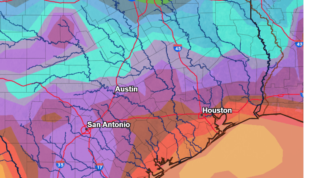
Rain totals over the next 7 days are forecast to be significant, with the highest totals expected across the coastal plains. Here, totals of 2-5 inches are predicted. Across the rest of the region, most totals are forecast to be in the range of 1-2 inches.
NWS Rainfall Forecast for the Period 7 pm Monday through 7 pm next Monday:
The outlook for next Tuesday through Friday calls for more scattered showers and thunderstorms across the region as tropical moisture lingers over our area. High temperatures are forecast to generally be in the low to mid-90s.
Tropical Weather Update
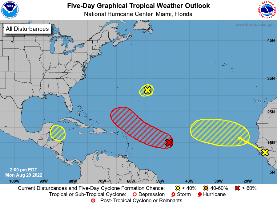
The National Hurricane Center is currently monitoring 4 areas of disturbed weather. So far, just one of the areas is showing a high likelihood of developing into a tropical cyclone.
The first area of disturbed weather is located over the over the northwestern Caribbean Sea where a trough of low pressure could develop later this week. Environmental conditions could support some slow development of the system thereafter while it moves generally west-northwestward over the northwestern Caribbean Sea, the Yucatan Peninsula of Mexico and the southwestern Gulf of Mexico. NHC forecasters are giving this system just a 20 percent chance for tropical development over the next 5 days.
The second area of disturbed weather is located over the central tropical Atlantic where a broad area of low pressure is producing a large area of disorganized cloudiness and showers. Although environmental conditions are only marginally conducive, some gradual development of this system is expected over the next several days and a tropical depression is likely to form later this week. The disturbance is forecast to move slowly toward the west and then west-northwest at 5 to 10 mph, toward the adjacent waters of the northern Leeward Islands. NHC forecasters are giving this system a 50 percent chance for tropical development over the next 2 days, and an 80 percent chance for development over the next 5 days.
The third area of interest is located about 600 miles east of Bermuda where a small low pressure system continues to produce limited shower activity. Strong upper-level winds and dry air are expected to limit significant development of this system while it drifts southward and southwestward over the central Atlantic during the next couple of days, and likely dissipate by the end of the week. NHC forecasters are giving this system just a 10 percent chance for development over the next 5 days.
Finally, the fourth area of interest is located over the far eastern tropical Atlantic where a tropical wave is forecast to move off the west coast of Africa this evening or early Tuesday. Some gradual development of this system is possible after that time while it moves generally westward to west-northwestward across the far eastern tropical Atlantic. NHC forecasters are giving this system a 10 percent chance for development over the next 2 days, and a 30 percent chance for development over the next 5 days.
Bob
Social Media