Over the weekend, a little rain fell over parts of the region as a weak area of low pressure moved inland, pulling an enhanced zone of tropical moisture with it. Most totals were just a few hundredths of an inch, but a few lucky spots saw totals close to a half inch.
Monday’s weather maps showed the center of the high pressure ridge, or heat dome, parked over the Four Corners region. Much of Texas remains under the influence of an east-to-west wind in lower and middle atmosphere, that is flowing around the base of the large upper ridge. This particular flow is pulling pockets of enhanced tropical moisture inland from the Gulf of Mexico. This increased level of moisture, combined with strong heating and a robust Sea Breeze is forecast to cause the development of isolated rain showers and thunderstorms across the coastal plains, Central Texas, and eastern Hill Country regions this afternoon and again Tuesday afternoon. The probability for rain both days is forecast to be near 30 percent across the coastal plains and near 20 percent at all other locations. Rain amounts are forecast to average less than a quarter inch.
- High temperatures Monday and Tuesday are forecast to be near 98-100 degrees across the Hill Country, near 99-102 degrees across Central Texas, and near 95-98 degrees across the coastal plains.
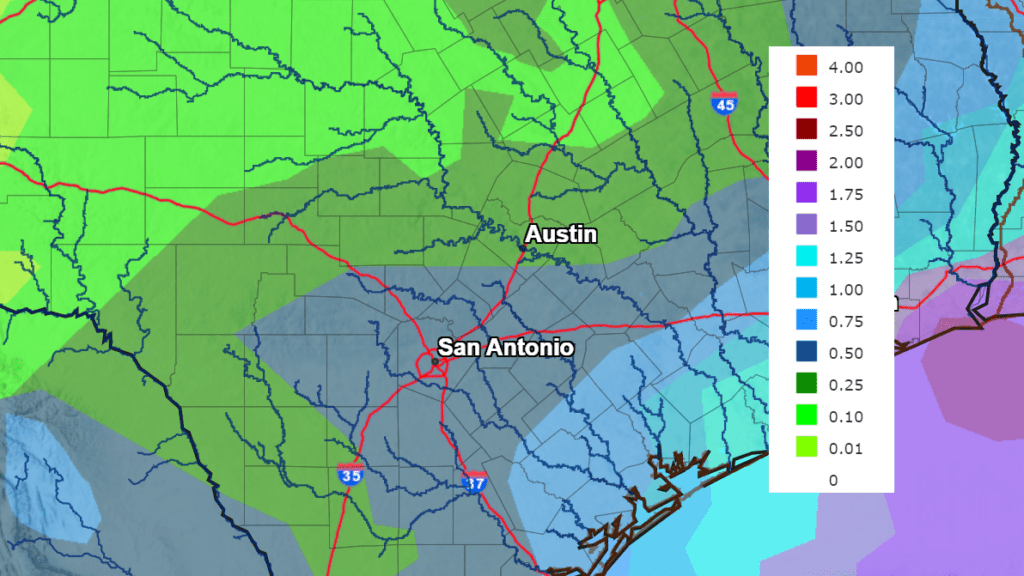
Forecasts are pointing toward a somewhat better chance for scattered rain showers and thunderstorms taking shape across the region beginning Wednesday and continuing through Friday, as the upper ridge shifts a little further to the northwest. At the same time, a couple waves of low pressure are forecast to move around the ridge and track into Texas from the northeast. With tropical moisture spreading inland in advance of the low pressure troughs, atmospheric conditions are looking favorable for the development of scattered rain showers and thunderstorms across the region. The probability for rain is forecast to be 30 percent Wednesday, near 50 percent Thursday and around 30 percent on Friday.
Rain amounts through period are not expected to be all that heavy. Totals are forecast to average around a quarter inch or less across the Hill Country, be between 0.25 and 0.5 inches across Central Texas, and between 0.5 and 1 inch across the coastal plains.
NWS Rainfall Forecast for the Period 7 pm Monday through 7 pm Saturday:
Expect a partly cloudy sky Wednesday through Friday. With more clouds and scattered rains around the area, temperatures are not predicted to be quite as hot as they’ve been recently. High temperatures are forecast to generally be in the mid and upper 90s across the Hill Country and Central Texas regions, and in the low to mid-90s across the coastal plains.
Heading into the weekend, drier and hotter weather looks to return as the upper ridge shifts more to the southeast. Expect high temperatures of 98-102 degrees across the Hill Country and Central Texas regions and in the mid-90s across the coastal plains.
Looking out into next week, forecasts are calling for a generally dry and hot weather pattern as the center of the heat dome moves to the southern Plains states for much of the week. Daily high temperatures are forecast to be near 99-103 degrees across the Hill Country and Central Texas regions, and in the upper 90s across the coastal plains.
Tropical Weather Update
The tropical weather season is finally beginning to show some signs of life. National Hurricane Center forecasters are monitoring a large area of showers and thunderstorms over the far eastern tropical Atlantic, south of the Cabo Verde islands. This activity is associated with a tropical wave that moved off the west coast of Africa over the weekend. This system has changed little in organization today, but environmental conditions appear conducive for gradual development over the next several days while it moves westward to west-northwestward at 15 to 20 mph across the eastern and central tropical Atlantic. A tropical depression could form by the middle to latter portion of this week before environmental conditions become less favorable by this weekend.
NHC forecasters are giving this system a 20 percent chance for tropical development over the next 48 hours, and a 40 percent chance for development over the next 5 days.
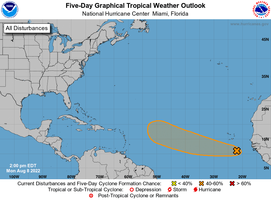
Elsewhere, weather conditions are quiet and tropical cyclone development is not anticipated.
Hottest July on Record for Texas
Data released from the National Weather Service Monday showed the temperature across Texas for July averaged 87.3 degrees–5 degrees above normal. This eclipsed the average temperature of July 2011 by 0.3 degrees, making July 2022 the hottest July on record.
Averaging June and July together, the average temperature for the first two months of summer is 85.6 degrees—ranking as the second hottest June-July on record for Texas, behind 2011’s 86.1 degrees.
Bob
Social Media