A mild weather pattern continues across Texas. In the wake of the arctic blast that occurred around Christmas, the coldest air has shifted back north into Canada. A westerly wind flow in the middle and upper atmosphere originating out of the Pacific is keeping the cold air up to the north, allowing for a generally mild pattern across Texas and much of the southern U.S. Forecasts show this pattern persisting for at least the next couple of weeks, meaning more mild temperatures are on the horizon.
Quiet weather is in place as we close out the workweek. Southerly breezes returned to the area Thursday night in response to an area of low pressure developing across the southern Rockies. Wind speeds are forecast to increase to a range of 10-20 mph, with gusts to 25 mph Friday afternoon and remain breezy through Friday night. Expect a mostly sunny sky and warm temperatures Friday afternoon, with readings climbing to the mid and upper 70s. The sky will become cloudy Friday night. Lows Saturday morning will range from the mid-50s across the Hill Country, to the low 60s near the coast.
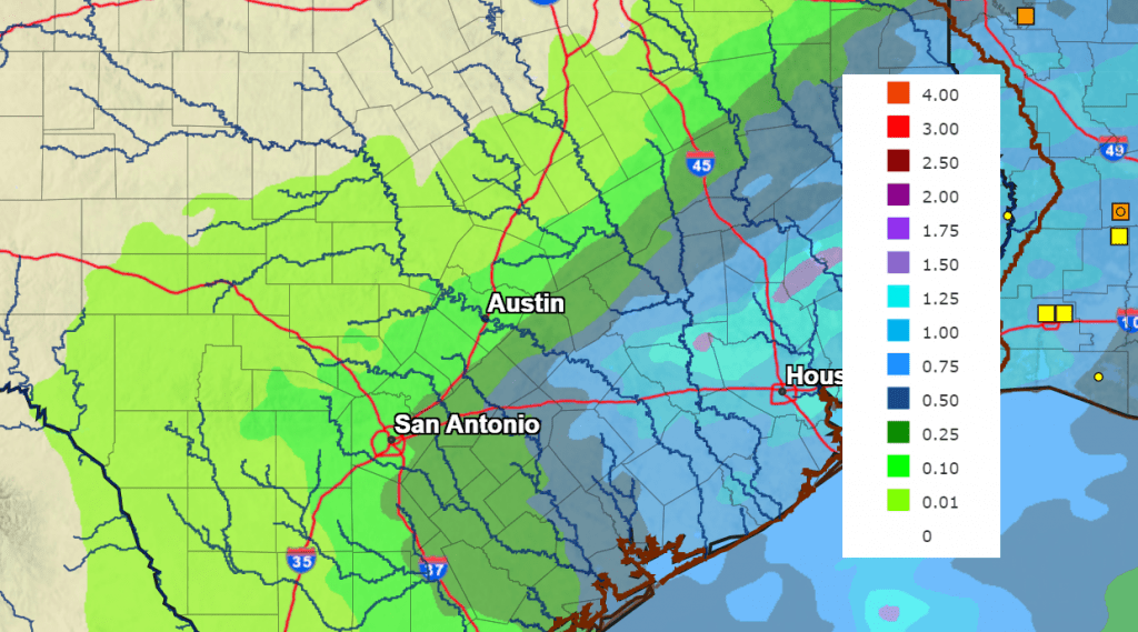
A chance for rain showers and scattered thunderstorms is forecast to develop for areas mainly along and east of Interstate 35 Saturday afternoon through Saturday night when a Pacific cold front slowly sinks southeast across the state. The front is predicted to reach the northern Hill Country late Saturday morning, cross the Austin/Interstate 35 corridor late Saturday afternoon into Saturday evening, then move across the coastal plains region Saturday night. With limited moisture in place, little to no rain is forecast across the Hill Country. However, higher moisture levels across the eastern half of the state will cause a 40-50 percent chance for rain and thunderstorms across Central Texas, and a 60-70 percent chance for rain and storms across the coastal plains.
Severe storms are not forecast. However, an isolated strong storm or two could produce some small hail and gusty winds. Rain showers and scattered thunderstorms are forecast Saturday afternoon through Saturday night across Central Texas and the coastal plains. The rain is predicted to exit Central Texas late Saturday night and diminish across the coastal region Sunday morning. Rain amounts are forecast to be heaviest Saturday through Sunday are predicted to be heaviest across Southeast Texas and the middle Texas coast, while lighter totals expected back across the Interstate 35 corridor. Forecasts call for storm totals of 0.25 to 0.5 inches across the Interstate 35 corridor, and 1-2 inches from the Smithville/La Grange area, southeast to the coast.
NWS Rain Forecast for the Period 6 pm Friday through 6 pm Monday:
Sunny weather is forecast to develop across the Hill Country and Central Texas regions Sunday morning, with the sunny weather expected to spread southeast to the coastal area Sunday afternoon. Sunny and dry weather looks to follow Monday through Wednesday as a weak ridge of high pressure sets up over the south central US. Slightly cooler air will follow Sunday’s cold front, but warmer readings will return Tuesday and Wednesday.
- High temperatures Saturday are forecast to be in the low and mid-70s.
- Lows Sunday morning will include the low 40s across the Hill Country, the mid and upper 40s across Central Texas, and the mid-50s across the coastal plains.
- High temperatures Sunday and Monday are forecast to be in the mid and upper 60s.
- Lows Monday morning will range from the low 40s west, to the upper 40s near the coast.
- High temperatures Tuesday and Wednesday are forecast to be in the low and mid-70s.
- Lows Tuesday and Wednesday mornings are predicated to be in the upper 40s to low 50s.
Forecasts call for a slight chance to a chance for rain showers to develop across the region next Wednesday night into early Thursday morning when the next Pacific cold front sweeps southeast through the state. Rain amounts with the front are forecast to only average around a tenth of an inch, or less. Mostly sunny and slightly cooler air will follow the cold front Thursday through Saturday.
- High temperatures Thursday through Saturday are forecast to be near 68-70 degrees.
- Low temperatures Friday, Saturday, and Sunday mornings are forecast to be in the mid and upper 40s.
Looking out into the week of January 16th, forecasts call for a chance for rain showers and thunderstorms to develop that Monday and Tuesday when a Pacific storm system tracks across Texas. Generally dry weather will follow Wednesday through Friday. Mild temperatures are forecast, with highs in the low 70s, and lows around 50 degrees.
Full Moon Friday Night
January’s moon will be full at 5:08 pm CST Friday afternoon, but if you don’t see it that night, don’t fret. It will appear virtually full the next couple of nights. The January full moon is commonly called the “Full Wolf Moon.” Native Americans and early settlers named it the Wolf Moon because January was associated with wolves howling outside of villages and being more active in winter.
Have a good weekend.
Bob
Social Media