Very heavy rain developed across parts of the Hill Country and Central Texas Sunday as weak cold front pushed south out of North Texas. The highest gauged totals occurred near central and downtown Austin, where amounts of 4-5 inches were recorded. Many locations saw totals between 1 and 2 inches. Meanwhile, some areas saw little to no rain. The official total for Austin-Camp Mabry was 2.4 inches. Austin-Bergstrom recorded 1.5 inches. Sunday’s storms diminished Sunday evening as temperatures cooled. The cold front brought in slightly cooler air to the Hill Country and the northern counties of Central Texas. Low temperatures Monday morning were in the mid and upper 60s across the Hill Country.
Monday’s weather maps showed the unusual cold front stationary across Central Texas. Monday’s analysis showed the atmosphere near and especially south of the front to be quite moist and moderately unstable. As temperatures warm this afternoon, conditions appear favorable for the development of showers and scattered thunderstorms across the region. Steering winds are fairly weak, so developing storms are predicted to be slow-movers, capable of producing large amounts of rain in a short period of time. Rain amounts are forecast to generally average between a quarter and a half inch, with isolated totals of 1-3 inches possible. The probability for rain will range from 30 percent across the northern Hill Country, to 50 percent across the coastal plains region. Some of today’s rain may linger into the evening hours, then diminish shortly after sunset. Today’s temperature is forecast to warm into the low and mid-90s.
A very similar pattern is forecast Tuesday through Wednesday as the front remains stalled across the area and a couple of atmospheric disturbances track across North Texas. A mostly sunny sky in the morning will give way to scattered showers and thunderstorms in the afternoon and evening. The probability for rain each day will generally be near 40-50 percent. Daily rain amounts will again average between a quarter and a half inch, with isolated totals of 1-3 inches possible. Expect high temperatures in the low and mid-90s.
Beginning Thursday, a drier pattern is forecast to develop as the front washes out and a ridge of high pressure over the southeastern U.S. nudges west over Texas. There will be a slight chance for a few isolated afternoon thunderstorms due to lingering moisture, but most locations should be sunny and dry. Expect a high temperatures in the mid-90s. Mostly sunny and dry weather is forecast Friday, with high temperatures in the mid and upper 90s.
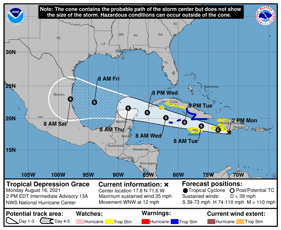
The outlook for the upcoming weekend is somewhat uncertain due to the eventual track and path of Tropical Depression Grace. As of late Monday morning, the depression was located near the coast of southern Hispaniola, about 85 miles southeast of Port Au Prince, Haiti. National Hurricane Center forecasts call for Grace to move west-northwest across the Caribbean over the next couple of days, re-strengthening into a tropical storm. Grace is forecast to pass the Yucatan Peninsula Thursday, moving into the Gulf of Mexico Friday. With the help from a ridge of high pressure located over the southeastern U.S., Grace is forecast to be steered into the northern coast of Mexico sometime early Saturday. There is a fairly good consensus among all of the computer-forecast solutions for Grace to push inland south of Texas this weekend. Based on this outlook, Grace is not expected to have any significant impact on the middle or upper Texas coast. Grace is expected to cause a good onshore flow from the Gulf into Texas this weekend, which may lead to the development of some scattered afternoon rain showers and thunderstorms. The best chance for rain will be across the coastal plains. Weekend weather conditions are forecast to be partly cloudy and hot, with high temperatures in the mid and upper 90s.
The outlook for next week calls for mostly sunny, dry and hot weather across much of Texas. Daily high temperatures will are forecast to be in the mid and upper 90s.
Tropical Weather Outlook
The National Hurricane Center is issuing advisories on Tropical Storm Fred, which made landfall on the eastern Florida Panhandle Monday afternoon, Tropical Depression Grace, located near the south coast of the Dominican Republic, and on Tropical Depression Eight, located a little over 100 miles east-southeast of Bermuda.
Tropical Storm Fred made landfall near Cape SanBlas, Florida, on the eastern Florida Panhandle, with maximum sustained winds estimated to be near 65 mph. Fred is forecast to track north and move over western Georgia on Tuesday.
Tropical Depression Grace is forecast to pass near the southern coast of Hispaniola today and tonight, and then pass between Jamaica, Cuba, and the Cayman Islands on Tuesday and Wednesday.
Tropical Depression Eight is forecast to make a slow clockwise turn toward the southwest and then toward the west over the next few days across the western Atlantic. On the latest forecast track, the center of the depression should move well to the south of Bermuda.
Bob
Social Media