An active period of weather is expected to develop across Texas beginning late this afternoon and continuing overnight. The most favorable area for strong to severe storms is expected to be across North and Northeast Texas, with a lesser chance for severe storms to occur across Central Texas and the Hill Country.
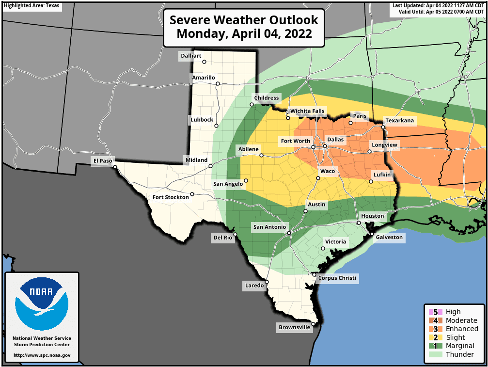
A trough of low pressure currently located over eastern New Mexico is forecast to track east across North Texas this evening and overnight, enhancing the potential for thunderstorm development across the region. However, forecasters will be closely monitoring Northwest Texas, where a cold front is currently stationary. Scattered strong to severe thunderstorms are forecast to develop along the front, with the storms tracking to the east across North Texas this evening and overnight. High-resolution forecasts indicate some of the thunderstorms may also develop further south, across the northern and central Hill late this afternoon and this evening. This activity is expected to spread to the east across Central Texas late this evening and toward midnight. The Storm Prediction Center has placed the area north of a line stretching from Menard, to Marble Falls, to Round Rock, to Bryan under a Slight Risk (a 2 out of 5 risk) for severe thunderstorms through sunrise Tuesday. Areas north of a line stretching from Eagle Pass, to Floresville, Schulenburg, and Houston (including the Austin metro area) have been placed under a Marginal Risk (a 1 out of 5 risk) for severe thunderstorms through sunrise Tuesday. The primary severe weather threats are forecast to be large hail and damaging downburst winds. In addition, there will also be a low end chance for a couple of isolated tornadoes.
A second opportunity for rain showers and thunderstorms is predicted to occur overnight, when the cold front over West Texas is pushed to the east. The probability for rain overnight will be 50 percent. The chance for rain is expected to end from west to east behind the cold front. The highest potential for rain is forecast to be across North Texas. Across the Hill Country, Central Texas, and middle Texas coast, most rain amounts are forecast to average less than a quarter inch. Lows Tuesday morning will range from the mid-50s across the Hill Country, to near 70 degrees across the coastal plains.
Sunny and unseasonably warm weather is forecast in the wake of the Pacific cold front across the region Tuesday. West and southwesterly down sloping breezes are expected to pull warm and dry air eastward out of Mexico. As a result, temperatures are predicted to reach summer-like levels. Expect winds speeds of 10-15 mph.
- High temperatures Tuesday are forecast to be in the mid-90s across the Hill Country, the low and mid-90s across Central Texas, and be close to 90 degrees across the coastal plains.
A breezy, dry, and much cooler mid and late week period is expected as a deep trough of low pressure develops from eastern Canada, to the Lower Mississippi Valley. This unusually strong trough will help draw at an impressive cold front south across Texas Wednesday, resulting in cooler temperatures that will last through late week. The cold front is predicted to push south across the state on Wednesday, with breezy northerly winds of 15-20 mph and gusts to 30 mph, developing in its wake Wednesday afternoon through Thursday. No rain is forecast along the front.
- High temperatures Wednesday will be in the mid and upper 70s. Upper 80s are forecast across the coastal plains.
- Lows Thursday morning will range from the upper 40s Hill Country, to the mid-50s coastal plains.
- High temperatures Thursday will generally be in the low and mid-70s.
- Lows Friday and Saturday mornings will be in the low and mid-40s, with upper 40s expected towards the coast.
- High temperatures Friday are forecast to be in the low and mid-70s.
Sunny and warmer is expected this coming weekend as the unusually cool air mass begins to push off to the east. High temperatures will be in the low and mid-80s, with lows in the 50s.
The outlook for next week calls for a somewhat unsettled weather pattern to develop across Texas. Forecasts call for a large trough of low pressure to set up across the western U.S., enabling small waves of low pressure to track east across Texas Monday through Thursday. These waves of low pressure will cause a chance for rain showers and isolated thunderstorms each day through Thursday. As of now, rain amounts are not shaping up to be all that impressive, with most totals forecast to be well under an inch. But this event is still a week away, and the forecast solutions will likely change/evolve over the next few days. Stay tuned for further updates. Next week’s temperatures are looking to be warm, with highs in the 80s.
Have a good week.
Bob
Social Media