A cluster of strong and at times severe thunderstorm tracked from west of San Antonio to near and Austin and Bastrop early Monday morning. The storms produced half inch to three quarter inch hail along their path before they moved into Southeast Texas. Rain amounts under the path of these storms were generally less than a quarter inch, although a couple of LCRA’s gauges in Bastrop and Lee Counties recorded totals just under a half inch.
Forecasters will be closely monitoring the eastern Hill Country and the Interstate 35 corridor this afternoon as the dry line moves in from the Edwards Plateau and Concho Valley regions. A couple of isolated thunderstorms will have the potential to develop across the eastern Hill Country and track east to the Interstate 35 corridor. Should any storms develop, they are forecast to quickly become severe, and produce large hail and damaging winds. The Storm Prediction Center has placed the central and eastern Hill Country, along with the Interstate 35 corridor, under a Marginal Risk (a 1 out of 5 risk) for severe thunderstorms through 7 am Tuesday.
With a fairly strong cap in place, the probability for rain and storms this afternoon will only be 20 percent. Rain from today’s potential storms should generally average less than a quarter inch. The sky will be sunny across the Hill Country this afternoon. Across Central Texas and the middle Texas coast, the sky is forecast to be partly to mostly cloudy. High temperatures will include the low 90s across the western Hill Country, the upper 80s across the central and eastern Hill Country, and low and mid-80s at most other locations. Expect a cloudy sky Monday night. Lows Tuesday morning are forecast to be near 70 degrees.
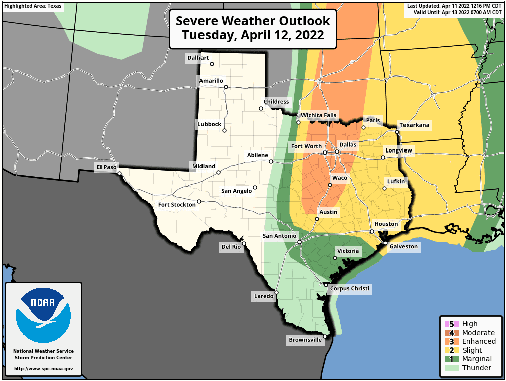
There will be an increased threat for strong to severe thunderstorms to develop across the eastern Hill Country, the Austin and Interstate 35 corridor, and parts of Central Texas Tuesday afternoon, continuing into Tuesday evening. Forecasts call of a wave of low pressure over Mexico to track northeast to the Edwards Plateau region Tuesday afternoon. At the same time, the dry line is forecast to push east out of West Texas, reaching the eastern Hill Country around mid-afternoon. There is a robust signal in most all available forecast model guidance pointing to the atmospheric cap breaking in the mid to late afternoon, along and immediately ahead of the dryline. This is expected to allow for the rapid development of severe thunderstorms near the dry line, with the activity spreading to the east in the late afternoon and evening. Very large hail, damaging winds and isolated tornadoes will be possible with these thunderstorms. The threat for storms is forecast to decrease from west to east Tuesday evening as the storms slowly push off to the east.
The Storm Prediction Center has placed the Interstate 35 corridor from the DFW area to just north of Austin under an Enhanced Risk (a 3 out of 5 risk) for severe thunderstorms Tuesday afternoon and Tuesday night. The eastern Hill Country, the Austin area, and most of Central Texas have been placed under a Slight Risk (a 2 out of 5 risk) for severe thunderstorms through Tuesday night. A lesser threat, for severe storms is forecast for the middle Texas coast.
Very large hail, damaging winds and isolated tornadoes will all be possible from Tuesday’s potential storms. The probability for rain and storms is forecast to be near 40 percent. Rain amounts are forecast to average around a quarter inch, with isolated totals to near 1 inch possible. Expect widespread morning clouds, followed by mostly sunny and breezy conditions in the afternoon. High temperatures are forecast to be near 88-90 degrees across the Hill Country and Central Texas regions, and in the mid-80s towards the coast.
There will be one last small threat for thunderstorms across the Hill Country and Central Texas regions early Wednesday morning when a Pacific cold front pushes southeast out of Northwest Texas. The chance for rain will only be 20 percent. The chance for rain and storms will end quickly behind the front as drier and warm air spreads in out of Mexico. Expect gusty southwesterly winds Wednesday morning. Winds look to become northwesterly behind the front in the afternoon. Wednesday’s temperature is forecast to warm close to 90 degrees across the Hill Country and Central Texas regions, with mid-80s expected towards the coast.
Mostly sunny weather is predicted for Thursday and Friday. High temperatures both days are forecast to be in the mid-80s, with lows in the upper 50s to low 60s.
The upcoming weekend is shaping up to be mostly sunny and quite warm, with high temperatures both days expected to be around 90 degrees. Lows will be in the 60s.
Looking ahead to next week, a Canadian cold front is forecast to push through the area Monday, bringing a slight chance for rain. Rain amounts will be low. Dry weather is then forecast for the remainder of the week. Slightly cooler air looks to follow the cold front next Tuesday through Friday. Expect daily high temperatures to be in the upper 70s to low 80s, with lows in the 50s.
Bob
Social Media