The weekend weather certainly felt like August with temperatures reaching the mid and upper 90s along with very high humidity. Fortunately, most readings stayed below 100 degrees. A similar hot pattern is forecast to be in place today through Wednesday before temperatures begin lowering about 2-3 degrees late week into the upcoming weekend.
Monday’s weather maps showed a broad ridge of high pressure, or heat dome, stretching from northwestern Mexico to the Ohio Valley. Interestingly, the ridge was centered over Central Texas—one of the few times observed over our area this summer. The ridge is of moderate strength, but not quite as strong as it was earlier in the summer. Forecasts call for the center of the ridge to remain across Central Texas through mid-week, then lift north to the southern Plains and the Middle Mississippi Valley late week and this weekend.
With the center of the ridge holding in place this afternoon through Wednesday, the weather will remain sunny, dry and hot. A spotty rain shower or two will be possible across the coastal plains region Tuesday and Wednesday, but rain amounts should only average around a tenth of an inch. Expect a south breeze at around 5-10 mph through the period.
- High temperatures this afternoon through Wednesday are forecast to be between 98 and 100 degrees across the Hill Country and Central Texas regions and in the mid-90s across the coastal plains.
On Thursday, a slight chance for scattered afternoon rain showers and isolated thunderstorms will enter the forecast for the eastern Hill Country, all of Central Texas and the coastal plains region as atmospheric moisture levels begin to rise and the high pressure ridge lifts to the north. The probability for rain will be near 20 percent across Central Texas and near 40 percent across the coastal plains. Rain amounts should average less than a tenth of an inch across Central Texas and be around a quarter inch towards the coast. High temperatures Thursday are forecast to be in the mid-90s across the Hill Country and Central Texas and in the low 90s towards the coast.
Friday through Sunday, the chance for showers and scattered thunderstorms is forecast to increase to near 50 percent across the coastal plains region as a weak disturbance brings an enhanced area of tropical moisture to the coastal plains region. Daily rain amounts are predicted to average between a quarter and a half inch, with isolated totals of 1-2 inches possible. Daily high temperatures will be in the low 90s.
For the Hill Country and Central Texas regions, there will be a 20-30 percent chance for scattered afternoon showers and thunderstorms Friday through Sunday. Daily rain amounts are predicted to average only around a tenth of an inch, with isolated totals to near a half inch. Daily high temperatures are forecast to be in the mid-90s.
Looking out into next week, all eyes will be on the Gulf of Mexico, where a potential tropical system is forecast to develop and possibly track toward northern Mexico or Deep South Texas early in the week. Forecast solutions call for an area of low pressure to move west off the Yucatan Peninsula this weekend, with the system tracking towards the coast of Mexico or Deep South Texas around next Monday or Tuesday. It’s possible some of the moisture associated with this system could work its way north into Central Texas and the middle Texas coast the middle of next week. There is much uncertainty surrounding this potential tropical system, so stay tuned over the next few days as the system evolves.
Aside from this feature, forecasts call for a broad, weak ridge of high pressure to be over Texas throughout much of next week. Expect a partly cloudy sky with daily high temperatures in the low and mid-90s.
Tropical Weather Update
The biggest feature in the tropics on this Monday is Tropical Depression Henri. As of late Monday morning, Henri was centered about 45 miles north-northeast of New York City. The depression is moving toward the east near 6 mph and this motion is expected to continue before accelerating later tonight. Maximum sustained winds are near 30 mph with higher gusts. Little change in strength is forecast during the next 48 hours. Henri is expected to produce additional rainfall of 1 to locally 2 inches in New Jersey, and eastern Pennsylvania through today and 1 to 3 inches, with locally higher amounts possible, over far southeast New York, Long Island, and southern to central New England through tonight.
National Hurricane Center forecasters are closely monitoring three other features in the tropical Atlantic.
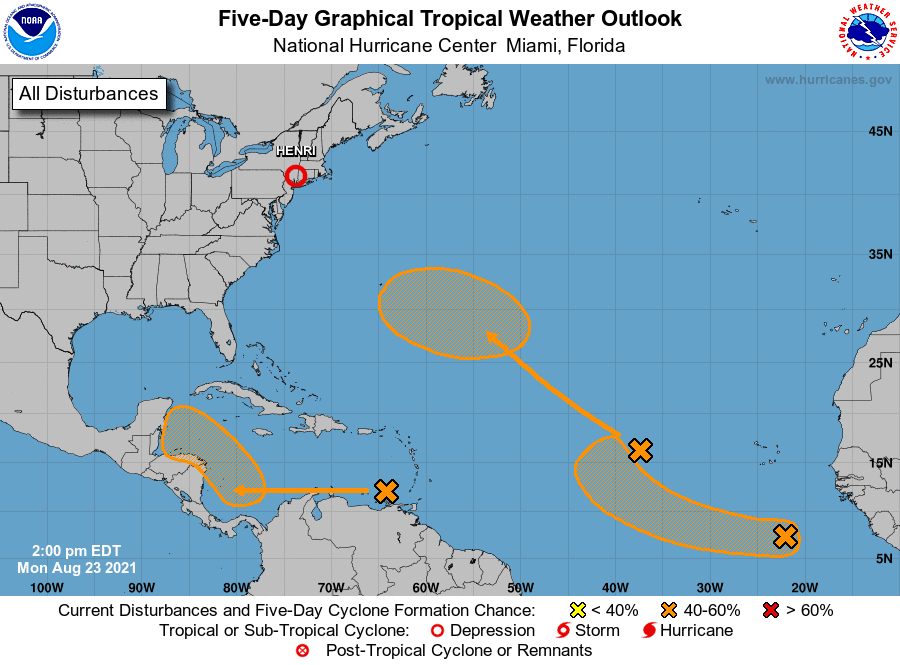
The first feature is a tropical wave located over the eastern Caribbean Sea. This system is expected to form a broad area of low pressure over the southwestern Caribbean Sea by late week. Thereafter, environmental conditions are forecast to become favorable for gradual tropical development while the system moves west-northwestward over the northwestern Caribbean Sea. NHC forecasters are currently giving this system a medium chance (a 40 percent chance) for tropical development over the next 5 days.
The second feature is located out over the eastern tropical Atlantic where a broad low pressure system is producing disorganized showers and thunderstorms. Little development is expected during the next couple of days due to only marginally conducive ocean temperatures. Thereafter, however, some gradual development is possible by the middle to latter part of the week while the system moves northwestward at 10 to 15 mph over the central Atlantic. This system doesn’t appear to pose a threat to the Caribbean Sea or the Gulf of Mexico. NHC forecasters are giving this system a medium chance (a 40 percent chance) for tropical development over the next 5 days.
The third feature is an area of disturbed weather that is also located out across the far eastern Atlantic, about 500 miles south-southeast of the Cabo Verde Islands. A small area of low pressure has developed system in the area. Some slow development will be possible over the next several days while the disturbance moves westward to west-northwestward at around 15 mph over the eastern tropical Atlantic. NHC forecasters are giving this system a medium chance (a 40 percent chance) for tropical development over the next 5 days.
Bob
Social Media