As August draws to a close, our region remains in the grips of a very hot, muggy and dry weather pattern. Monday’s weather maps showed the powerful ridge of high pressure which was recently in place over the western U.S. has shifted south and now stretches from northern Mexico to the Southeastern U.S. To the north of ridge, the southern branch of the jet stream is flowing from southern California to the southern Plains and the Middle Atlantic. Disturbances embedded within the jet stream are forecast to move across the southern Plains this week, bringing periods of rain and storms to parts of West, North and Central Texas. The combination of scattered rain showers and a weakening high pressure ridge will bring less hot temperatures for the second half of the week and the upcoming Labor Day weekend.
For this afternoon and tonight, the heat wave will continue with few changes expected to the weather pattern. Today’s sky will be mostly sunny. A few scattered rain showers will be possible across the coastal plains region while dry weather will continue for most other locations. High temperatures will be near 100-102 degrees across the Hill Country and Central Texas regions and in the middle to upper 90s across the coastal plains. Lows Tuesday morning will generally be near 78-80 degrees.
Rain showers and scattered thunderstorms are forecast to increase in coverage Tuesday across West and Northwest Texas as a trough embedded within the jet stream tracks east out of New Mexico. The rain and thunderstorm activity is predicted to expand in coverage to include the northern half of the Hill Country, for the area north of a Junction to Llano to Waco line, Tuesday afternoon into Tuesday night. A couple of these storms may be strong to severe, producing damaging winds and large hail. Across the southern half of the Hill Country, Central Texas and the coastal plains regions, just a slight chance for showers is forecast Tuesday afternoon. High temperatures Tuesday will include the mid and upper 90s across the Hill Country, be near 100-103 degrees across Central Texas and be in the mid to upper 90s across the coastal plains.
Tuesday night into Wednesday morning, a chance for rain and thunderstorms will continue across the northern Hill Country but will expand to include the southern Hill Country and the Austin/Interstate 35 corridor. The probability for rain will be near 60-70 percent across the Hill Country and be near 40 percent along the I-35 corridor. Just a slight chance for rain is forecast for areas east of I-35. Rain amounts between Tuesday afternoon and midday Wednesday are forecast to average between 0.5 and 1 inch across the Hill Country, with isolated totals of 2+ inches possible. Across the eastern Hill Country and the I-35 corridor, totals of 0.25-0.5 inch are forecast.
Wednesday afternoon through Wednesday night, there will be a 40-50 percent chance for additional scattered rain showers and thunderstorms across the Hill Country, with a 20-30 percent chance for scattered rain showers and thunderstorms for the Austin/Interstate 35 corridor. Just a slight chance for rain is forecast for locations east of I-35. High temperatures Wednesday are forecast to be near 95-98 degrees across the Hill Country, be around 100 degrees across Central Texas and be in the mid-90s across the coastal plains.
Thursday through Saturday, just a slight chance for mainly afternoon and evening rain showers and thunderstorms is forecast across the entire region as weak disturbances track from west to east near the Red River. Daily rain amounts are forecast to average less than a quarter inch. High temperatures through the period are forecast to be in the mid-90s across the Hill Country, the upper 90s across Central Texas, with mid-90s expected towards the coast.
Sunday, Labor Day into next Tuesday, mostly sunny, dry and hot weather is forecast as the ridge of high pressure becomes reestablished across the west. Daily high temperatures look to be in the mid to upper 90s across the Hill Country and Central Texas regions and in the low to mid-90s towards the coast.
Forecast call for a deep trough of low pressure to develop from the Great Lakes to the Lower Mississippi Valley beginning the middle and latter parts of next week. This unusually deep trough will allow a Canadian cold front to sweep south through Texas next Tuesday night into Wednesday. An area of rain showers and thunderstorms will accompany the cold front with dry weather and noticeably cooler temperatures following next Wednesday through Friday. High temperatures are predicted to fall to the upper 80s, with low temperatures falling to the 60s. 50s will be possible across parts of the Hill Country.
Tropical Weather Outlook
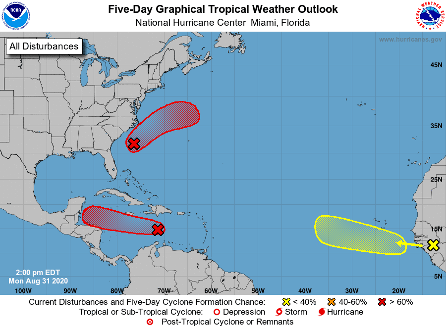
The tropics are quite busy, with several tropical waves in place. We will need to keep a close eye on the first of these tropical waves, currently located over the central Caribbean Sea.
A broad area of low pressure associated with a tropical wave is located over the central Caribbean Sea. This system has changed little in organization since Sunday and satellite-derived winds indicate that there is no closed circulation. However, environmental conditions are expected to gradually become more conducive for development, and a tropical depression is likely to form during the next couple of days. The system is forecast to move to the west at about 15 to 20 mph, reaching the coast of Belize or the southern Yucatan Peninsula this weekend. NHC forecasters are giving this system an 80 percent chance for tropical development over the next 5 days.
A tropical wave is expected to emerge off the coast of Africa in the next day or two. Gradual development of this system will be possible through the end of the week while it moves slowly westward over the far eastern tropical Atlantic Ocean. NHC forecasters give this system a 30 percent chance for tropical development over the next 5 days.
Finally, an area of low pressure is located about 135 miles southeast of Wilmington, North Carolina. This system continues to become better organized and a tropical depression is likely to form later today or tonight while the system moves northeastward, near but offshore of the southeastern coast of the United States and then away from land. NHC forecasters give this system a 90 percent chance for tropical development over the next 5 days.
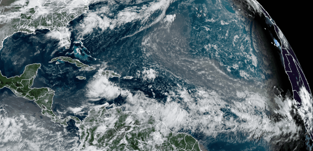
NOAA-RAMMB 08/31/2020 1:10 pm CDT
September Full Moon
The September full Moon will occur early Wednesday morning at 12:22 am CDT. The September moon is often called the Full Corn Moon or the Full Harvest Moon. This full Moon name is attributed to Native Americans because it marked when corn was supposed to be harvested. Most often, the September full Moon is actually the Harvest Moon, which is the full Moon that occurs closest to the fall equinox.
Bob
Social Media