Temperatures have been fairly tolerable so far this summer, but this experience will likely change beginning this weekend and early next week as a weather pattern more typical for late July sets up across most of Texas. Medium and long-range solutions indicate these hotter temperatures will be with us as we close out the month of July and move into August. As of now, forecasts are not calling for any unusually hot or record-setting temperatures to develop over the next couple of weeks as the center of the heat ridge is forecast to remain to our north and west.
Friday’s weather maps showed the area of low pressure responsible this week’s scattered rains has shifted from west central Texas out to eastern New Mexico and the Texas South Plains. With the low further to the west, the recent flow of tropical moisture from the Gulf of Mexico into Central Texas has diminished. But the biggest feature of interest on today’s maps is a large ridge of high pressure in the middle and upper atmosphere situated over the Gulf of Mexico and the Lower Mississippi Valley. The ridge is forecast to spread northwest across Texas this weekend and the early part of next week, and cause a pattern of sunny, dry and very hot weather. There will be a persistent southerly breeze in the range of 10-15 mph this afternoon and Saturday, but wind speeds look to decrease to 5-10 mph Sunday and Monday.
- High temperatures this afternoon are forecast to generally be in the mid-90s.
- High temperatures Saturday are forecast to be mid to upper 90s.
- High temperatures Sunday through Tuesday are forecast to be in the in the upper 90s across the Hill Country and Central Texas regions and in the mid-90s across the coastal plains.
Peak heat index values are forecast to be near 100-105 degrees across the Hill Country and Central Texas regions and near 105-110 degrees across the coastal plains.
Some small changes in the weather pattern are predicted for next Wednesday and Thursday when the ridge shifts northwest to the southern Rockies. At the same time, a weak non-tropical area of low pressure is forecast to track inland across South Texas. This system is expected to pull a limited amounts of tropical moisture inland. Forecasts call for the development of a few scattered afternoon rain showers and isolated thunderstorms over areas mainly along and east of Interstate 35. The probability for rain both days is predicted to be near 30-40 percent across the coastal plains region and near 20 percent at most other locations. For spots that do happen to see rain, totals should remain below a quarter inch.
- High temperatures Wednesday and Thursday are forecast to be in the upper 90s across the Hill Country, the mid-90s across Central Texas and the low 90s across the coastal plains.
Sunny, dry and hot weather looks to resume next Friday and continue through the following weekend as Texas remains under the influence of a broad ridge of high pressure centered over the southern Rockies and the southern Plains.
- High temperatures next Friday through next Sunday are forecast to be near 98-101 degrees across the Hill Country and Central Texas regions and in the mid-90s across the coastal plains.
Looking out into the first week of August, more sunny and very hot weather is forecast as the center of the upper ridge shifts to the Desert Southwest. High temperatures are forecast to be in the upper 90s across the Hill Country and Central Texas regions and in the mid-90s across the coastal plains. Welcome to August weather!
Tropical Weather Outlook
National Hurricane Center forecasters are closely monitoring a trough of low pressure located just offshore of the southeastern United States coastline. This system is producing an area of disorganized showers and thunderstorms. Environmental conditions appear marginally conducive for additional development and a tropical depression could form over the next couple of days as the system meanders over the Gulf Stream, just offshore of the southeastern United States.
NHC forecasters are giving this system a medium chance (a 40 percent chance) for tropical development over the next 5 days.
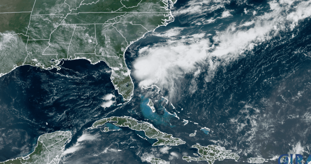
NOAA/Colorado State University/RAMMB 07/23/21 11:10 am CDT
Elsewhere across the tropical Atlantic, weather conditions are quiet and dusty. Tropical cyclone development is not expected for at least the next 5 days.
Saharan Dust Poised to Spread into Texas
Friday’s satellite images showed a large area of Saharan dust covering the western Gulf of Mexico that is spreading to the northwest. Forecasts call for the dust to spread inland to South and Central Texas late Friday into Saturday, with the dust persisting into Sunday. The dust concentration is predicted to weaken and dissipate late Sunday into Monday.
According to forecasts from the Texas Commission on Environmental Quality (TCEQ), the PM 2.5 Air Quality Index is forecast to be in the lower end of the “Moderate” range in the Austin/San Antonio regions both Saturday and Sunday due to the dust. In the moderate range, the air quality is acceptable. However, there may be a risk for some people, particularly those who are unusually sensitive to air pollution.
The dust over the Gulf of Mexico, the Caribbean Sea and the tropical Atlantic out to the coast of Africa shows up very nicely in this GOES 16 image that is focused on the Saharan Air Layer. The darker the color present, the great the concentration of dust.
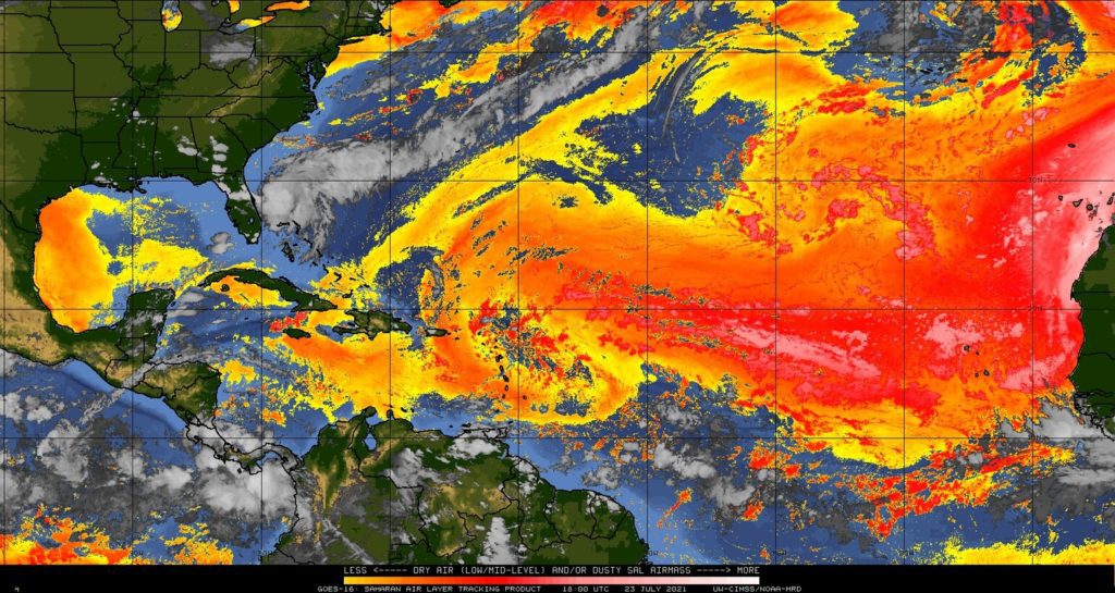
UW-CIMSS/NOAA-HRD 07/23/21 1:00 pm CDT
Have a good weekend.
Bob
Social Media