A quiet, pleasant fall weather pattern continues across Central and South Texas. A deep trough of low pressure in the upper atmosphere over the eastern U.S. is allowing a series of cold fronts to bring cool, Canadian air into Texas while keeping the moist and warm Gulf air to our south. Forecasts call for the current weather pattern to remain in place all week. Although daytime temperatures are expected to trend a bit higher this week, low relative humidity levels will keep conditions fairly pleasant.
High temperatures this afternoon will generally be in the middle 80s, warming to the upper 80s on Tuesday. High temperatures Wednesday through Friday will be near 88-90 degrees. Lows this week will be in the mid and upper 50s across the Hill Country, in the low 60s across Central Texas and in the mid to upper 60s across the coastal plains.
Changes in the weather pattern are forecast to take place this coming weekend and early next week as both the eastern trough and the southwestern ridge weaken. Forecasts call for a Pacific cold front to push east across Texas sometime next Tuesday into Tuesday night. Ahead of the front, warm moist air will return off the Gulf of Mexico this weekend and early next, leading to warmer and more humid conditions. The weather will be sunny and dry across the Hill Country and Central Texas regions Saturday through Monday, but a few spotty rain showers will be possible across the coastal plains region beginning on Sunday. High temperatures Saturday through Monday are forecast to be in the low and mid-90s across the Hill Country and Central Texas regions and be around 88-90 degrees across the coastal plains region.
A few spotty rain showers and isolated thunderstorms will be possible along and just behind the cold front late Tuesday into Tuesday night. Rain amounts, if any, are forecast to average well below a quarter inch. Mostly sunny and dry weather is expected late Wednesday through Friday, with high temperatures mostly in the mid and upper 80s. Lows will be in the low and mid-60s.
Tropical Weather Update
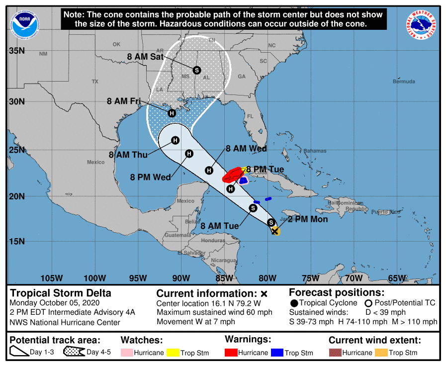
Tropical Storm Delta
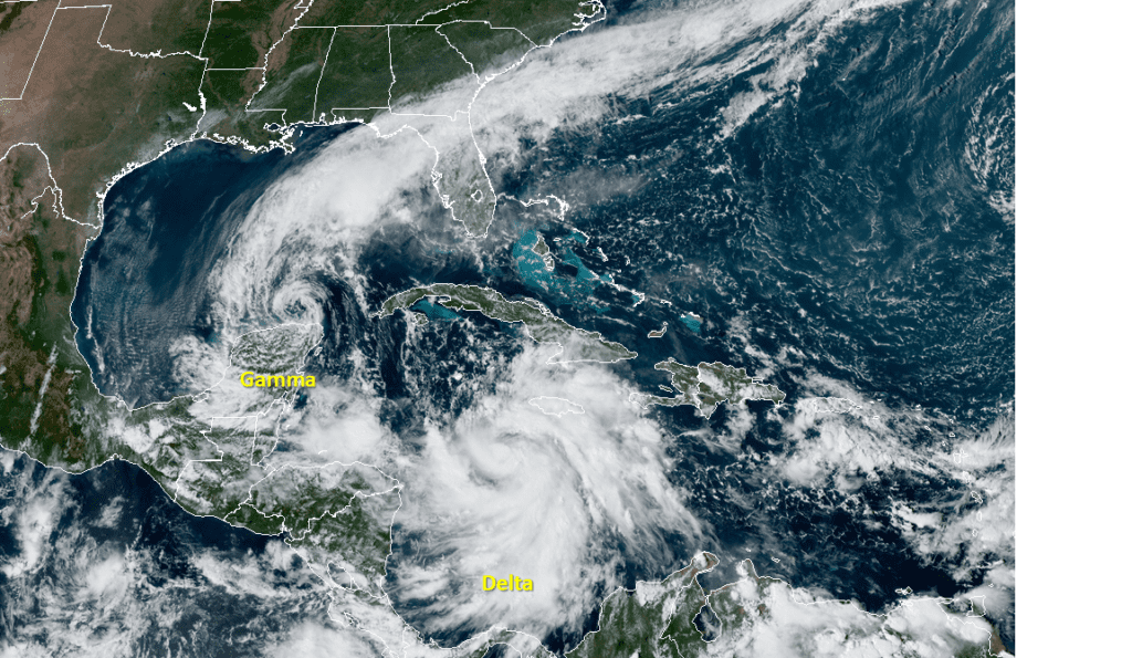
A strong tropical wave moving westward this weekend across the Caribbean Sea has developed into Tropical Storm Delta and the system is quickly strengthening. As of 1 pm CDT, the center of Delta was centered over the western Caribbean Sea, about 255 miles south-southeast of Grand Cayman. Delta is moving toward the west near 7 mph and a turn toward the west-northwest is forecast later today. A faster northwestward motion is expected on Tuesday and Wednesday. Maximum sustained winds have increased to near 60 mph with higher gusts. Additional strengthening is expected during the next few days, and Delta is expected to become a hurricane tonight or Tuesday before it nears western Cuba.
Delta is forecast to move northwestward around the southwestern portion of a deep-layer ridge of high pressure tonight and Tuesday, and that general motion with some increase in forward speed is expected to continue through 60-72 hours. After that time, a broad mid- to upper-level trough is forecast to develop over the south-central United States, which should weaken the western portion of the ridge and cause Delta to turn northward toward the northern Gulf Coast. After Thursday, Delta should begin to accelerate north-northeastward or northeastward ahead of the aforementioned trough. On the current forecast track, the center of Delta is expected to move away from Jamaica later today, move near or over the Cayman Islands early Tuesday, and approach western Cuba and the Yucatan Channel Tuesday afternoon or evening.
NOAA-RAMMB/CIRA 10/05/2020 1:00 pm CDT
Based on the latest forecast data, Delta is not expected to be a threat to the Texas coast. The cone of uncertainty at the time of landfall currently extends from the Texas/Louisiana border east, to just south of Tallahassee. Florida. No direct impacts to the Texas coast are expected at this time. However swells and tides may increase toward the middle and end of this week due to the circulation of Delta.
Tropical Storm Gamma
Tropical Storm Gamma poses no threat to the Texas coast. As of 1:00 pm CDT, the center of Tropical Storm Gamma was located just north of the Yucatan Peninsula, roughly 135 miles north-northwest of Cozumel, Mexico. Gamma is moving toward the southwest near 4 mph and this general motion is expected to continue through Wednesday morning. On the forecast track, the center of Gamma should move inland over the northwest coast of the Yucatan Peninsula Tuesday night and remain inland through Thursday.
Maximum sustained winds have decreased to near 40 mph with higher gusts. Gradual weakening is forecast, and Gamma is expected to become a depression this evening and degenerate to a post-tropical remnant low tonight.
This Week’s Close Encounter with Mars
Get ready. Earth and Mars are about to have a close encounter–one of the best since 2003. On Tuesday, Oct. 6th, Mars will be only 62 million km from Earth — it won’t be this close again until 2035 One week later, on the 13th, Mars will be at what astronomers call opposition, directly opposite the Sun in the sky, rising at sunset and setting at sunrise. The Red Planet will be well up in the east by about 9 p.m., and it’ll look almost alarmingly bright. Don’t miss it all this week!
Bob
Social Media