A slightly better chance for scattered rain showers has entered the forecast for Wednesday. Tuesday’s weather maps showed the center of the summertime heat dome has loosened its grip on Texas weather, shifting from southern Oklahoma Monday, to western Nebraska on Tuesday. With a slightly weaker ridge expected over the area Wednesday into Thursday, conditions have become a bit more conducive for the development of scattered rain showers and isolated thunderstorms Wednesday and Thursday afternoons. Unfortunately, rain amounts are not expected to be very significant.
On Wednesday, a weak, non-tropical area of low pressure is forecast to push inland across Deep South Texas and northeastern Mexico. This system is expected to push an area of tropical moisture inland, resulting in the development of scattered afternoon and evening rain showers and isolated thunderstorms. The probability for rain at most locations is forecast to be 30 percent Wednesday and 20 percent on Thursday. In general, weather conditions both days are expected to be partly cloudy and hot, with high temperatures in the mid-90s.
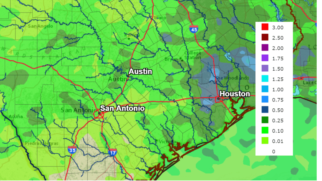
For locations that do see rain, totals Wednesday through Thursday are forecast to only average between a tenth and a quarter inch.
NWS Rainfall Forecast for the Period 7 pm Tuesday through 7 pm Thursday:
Sunny, hot and dry weather is forecast to resume Friday and persist through next Monday as the center of the high pressure ridge shifts back to the southern Plains states. Daily high temperatures are forecast to be near 100-102 degrees across the Hill Country and Central Texas regions and in the mid-90s towards the coast.
Longer-range forecasts for next week have changed from Monday’s original outlook. Forecasts now call for the heat ridge to shift to the west, allowing a weak cold front to sink south in Central Texas next Tuesday. The front is expected to cause the development of scattered showers across the region Tuesday and Wednesday. In addition, the front will cause temperatures to moderate down a bit into the mid-90s Tuesday through Friday.
Just when we thought the hot and dry pattern was here to stay for the next month, some unexpected (and pleasant) changes seem to be in store for next week. Stay tuned for more updates.
Bob
Social Media