Forecasters are gaining confidence a break from the recent stretch of unusually hot and dry weather will begin to take place this weekend when a cold front sinks south out of North Texas, bringing thunderstorms and cooler temperatures. This break in the pattern is expected to last through the middle of next week, allowing for additional chances for rain and thunderstorms to continue through Wednesday.
A chance for rain and thunderstorms is predicted to occur across the Hill Country and Central Texas regions Friday evening into Friday night when a small trough of low pressure tracks northeast out of Mexico. This system is forecast to cause the development of scattered thunderstorms, with some of the storms possibly producing large hail and damaging winds. Rain amounts look to average less than a half inch.
But the real change in the weather pattern is forecast to take place late Saturday afternoon and Saturday night when a cold front slowly pushes south through the Hill Country and Central Texas regions. Forecasts call for a 40-50 percent chance for rain and thunderstorms along and behind the cold front Saturday night, with the chance for rain diminishing Sunday morning. Across the coastal plains region, the cold front isn’t expected to arrive until Sunday afternoon, with the chance for rain increasing Sunday afternoon into Sunday evening. Rain amounts across the region through Sunday evening are forecast to generally average between 0.5 and 0.75 inches.
High temperatures Sunday are forecast to be close to 80-82 degrees.
Forecasts call for several waves of low pressure to track east across Texas next Monday through Wednesday night, with multiple rounds of widespread rain showers and thunderstorms expected during that time. Conditions appear favorable for the development of moderate periods of rain along with some locally heavy downpours. Totals close to an inch or possibly more are forecast each day Monday through Wednesday.
High temperatures Monday through Wednesday are forecast to generally be in the low and mid-80s. Dry and warmer weather looks to return for next Thursday and Friday.
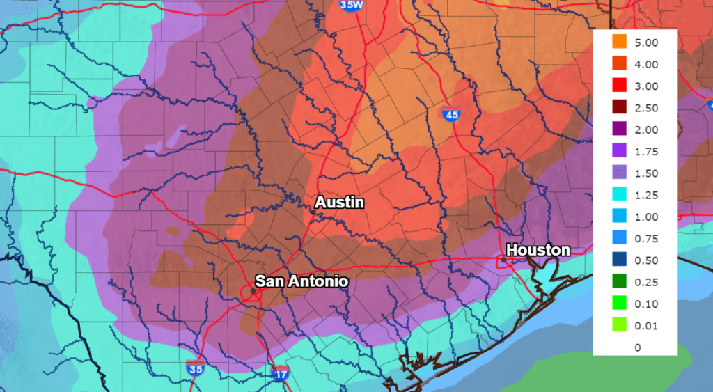
Rain totals over the next 7 days are shaping up to be significant. The National Weather Service is forecasting totals to generally be in the range of 2-3 inches across most of the region. Isolated higher totals will be possible.
NWS Rainfall Forecast for the Period 7 pm Thursday through 7 pm next Thursday:
After such a hot and dry start to May, this upcoming break will be amazing! Stay tuned for additional updates.
Bob
Social Media