It’s been a wet week across parts of the Hill Country and Central Texas regions, with some areas receiving between 4 and 7 inches of rain. However, most areas have seen totals more in the range of 0.5-1.5 inches. As of Friday afternoon, the western Hill Country and the coastal plains region south of Highway 59 has seen little to no rain. Friday morning, an area of moderate to heavy rain developed over parts of Travis and Hays Counties, producing totals of 2-6 inches along and just east of Interstate 35.
National Weather Service Rainfall Estimate for the Period 3 pm Tuesday through 3 pm Friday:
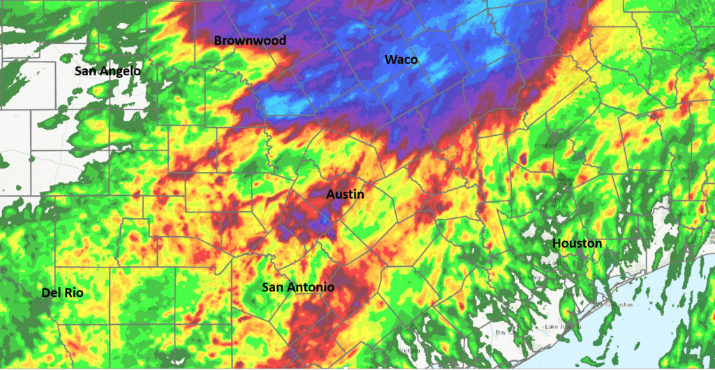
An unsettled weather pattern remains in place across much of Texas. A trough of low pressure separating the ridge of high pressure over the Western U.S. from the ridge of high pressure over the Southeastern U.S stretched from southern Missouri to Southwest Texas, near Del Rio. The trough has allowed the atmosphere over Texas to become quite moist and fairly unstable. Small-scale atmospheric disturbances within the trough have helped spark the recent pockets of very heavy rain.
This afternoon into this evening, numerous rain showers and thunderstorms are forecast to continue across the Austin/Central Texas area. In addition, rain and thunderstorms are predicted to increase in areal coverage across the Hill Country along with the middle Texas coast. The probability for rain will be near 70 percent across the Hill Country, near 100 percent across Central Texas and near 40 percent across the coastal plains. Some of today’s rain may be heavy—especially for areas along and near the Escarpment, where additional totals of 1-3 inches will be possible. With the ground quite wet from this morning’s rains, this additional rain will cause an increased threat for flash flooding. For the Hill Country and coastal regions, totals will generally average between 0.5 and 1 inch, with isolated heavier totals. The majority of the rain is forecast to diminish late this evening. Today’s high temperature will range from around 80 degrees across Central Texas to the low and mid-80s across the Hill Country to the lower 90s across the coastal region.
The outlook for Saturday calls for a very similar pattern across the region. Even though the upper trough is predicted to shift slightly to west, a moist and unstable atmosphere will continue. Periods of rain showers and thunderstorms are forecast across the entire region through Saturday evening. The probability for rain will near 60-70 percent across the Hill Country and Central Texas regions and near 40 percent across the coastal plains. Rain amounts Saturday are forecast to average around a half inch, with isolated totals of 1-2 inches possible. Saturday’s sky is expected to stay mostly cloudy. High temperatures will generally be in the upper 80s to low 90s.
The outlook for Sunday and Labor Day calls for a decreasing chance for rain and warmer temperatures as the upper trough weakens and lifts to the northeast. The ridge of high pressure out west is forecast to spread across Texas, causing a drier pattern. For the Hill Country and Central Texas regions, the probability for rain will be near 20 Sunday and less than 20 percent Monday. Rain amounts should average less than a quarter inch. For the coastal plains region, the probability for scattered rain showers will be near 30 percent both days with rain amounts averaging around a half inch. High temperatures both days will be in the low to mid-90s.
A big change in the weather pattern is forecast to take place the middle of the week. Forecasts call for an unusually strong trough of low pressure to sink south across the Rockies early next week, with the trough stalling over the Desert Southwest Wednesday into Thursday. The approaching through will allow a Canadian cold front to push south across Texas Tuesday night into Wednesday morning. The front is expected to bring a push of noticeably cooler air that looks to stick around through late week. In addition, rain showers and scattered thunderstorms are forecast to accompany the cold front when it moves across our area beginning Tuesday night. An overrunning pattern of clouds, rain showers and isolated thunderstorms look to follow the cold front Wednesday into Thursday. Rain amounts Tuesday night through Thursday night are forecast to generally average around 1-1.50 inches. The chance for rain should diminish late Thursday as the western trough lifts off to the northeast.
The front is expected to bring near fall-like temperatures to our area for the second half of next week.
- High temperatures Wednesday will range from the low 70s across the Hill Country, to the mid and upper 70s across Central Texas to the mid-80s near the coast.
- Lows Thursday and Friday mornings will be in the upper 50s to low 60s across the Hill Country, in the mid-60s across Central Texas and in the upper 60s across the coastal plains.
- High temperatures Thursday will include the upper 70s Hill Country, low 80s Central Texas and the mid-80s towards the coast.
- High temperatures Friday will be in the mid and upper 80s.
Mostly sunny weather is expected to continue into next weekend. High temperatures are predicted to be in the upper 80s, with low temperatures in the mid-60s. There are no signs on any hot weather returning through middle of the month.
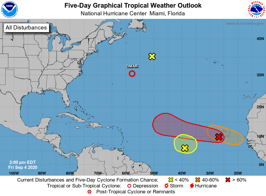
Tropical Weather Outlook
Conditions are currently quiet across the Gulf of Mexico and the Caribbean Sea. Hurricane Nana moved inland over Belize late Thursday. Tropical Storm Omar is over the northern Atlantic and is forecast to decrease to a remnant low pressure system sometime Friday night or Saturday. No tropical threats to the Gulf of Mexico are forecast for the next 5 days.
Forecasters are monitoring a non-tropical area of low pressure located over the north-central Atlantic about 500 miles south-southeast of Cape Race Newfoundland. This low is expected to move north-northeastward near 15 mph, but no tropical or subtropical development is expected.
The NHC is watching a nearly stationary area of low pressure located over the east-central tropical Atlantic about midway between the west coast of Africa and the Windward Islands. This system continues to produce disorganized showers and thunderstorms, and some development is possible during the next couple of days before it merges or interacts with a large tropical wave located to its east. The NHC gives this system a 30 percent chance for development over the next 5 days.
Another tropical wave located just west of the Cabo Verde Islands is producing a large area of disorganized showers and thunderstorms. Gradual development of this system is expected as it moves westward to west-northwestward, and a tropical depression is likely to form here late this weekend or early next week when the system reaches the central tropical Atlantic. The NHC is giving this system an 80 percent chance for development over the next 5 days.
Finally, a tropical wave is forecast to move off the west coast of Africa on Sunday. Gradual development of this system is then expected, and a tropical depression could form by the middle of next week while it moves generally westward over the far eastern tropical Atlantic. NHC forecasters are giving this system a 60 percent chance for development over the next 5 days.
Catch the Planet Mars
Mars is big, bright and close as it nears its October 13th opposition. This week it rises bright orange — shining at magnitude –2.0! — in the east soon after the end of twilight. It climbs higher through the evening and stands at its highest and telescopic best around 3 or 4 am CDT, lording over the world from high in the south.
Saturday evening, the Moon and Mars will rise close together in the east about a half hour after the end of twilight. For skywatchers in North America they’ll be only about 1° apart or less. By dawn Sunday, they’ll stand high in the southwest 2° or 3° apart.
I hope everyone has a safe and happy holiday weekend.
Bob
Social Media