Increased Fire Danger Thursday
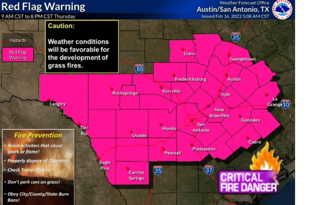
The National Weather Service has posted a Red Flag Warning for the Hill Country and all of Central Texas, from 9 am to 8 pm Thursday. A Red Flag Warning means the combination of very low relative humidity levels, strong winds and dry fuels will cause critical fire weather conditions and a very high fire danger.
A dry cold front is forecast to track south through our region Thursday morning into early Thursday afternoon. Behind the front, northwesterly winds are predicted to increase to 20-25 mph, with gusts to 35-40 mph. At the same time, relative humidity readings are forecast to fall to the teens and low 20s. With considerable dry, to critically dry vegetation covering much of the area, a high fire danger will be in place. Residents across the Hill Country, Central Texas and the coastal area are urged to avoid activities Thursday which could inadvertently cause a wildfire.
Fire Weather Safety Tips:
- Do not throw cigarette butts out of your car window.
- Be careful to not drag trailer chains that could cause sparks.
- Do not park a recently driven car on dry grass.
- Avoid activities with open flames or sparks.
- Avoid power equipment that creates sparks.
- Avoid outdoor burning and check recently burned piles for flare-ups.
Outdoor Burn Bans are currently in place for Travis, Hays, Caldwell, Lee, Fayette, Llano, San Saba, Lampasas and Mills Counties.
Weather Outlook
This afternoon’s weather is predicted to be mostly cloudy, breezy and warm. Although considerable moisture is spreading north from the Gulf of Mexico, stable conditions in the middle and lower atmosphere will act to limit the development of showers and thunderstorms. However, a few spotty, light rain showers will be possible across the middle Texas coast. This afternoon’s temperature is forecast to reach the mid-70s. Expect a strong south wind at 15-20 mph, with occasional gusts to 30 mph.
There will be a slight chance for a few showers and isolated thunderstorms across the region from late Wednesday evening through early Thursday morning when a Pacific cold front pushes southeast out of West Texas. The probability for rain will only be near 20-30 percent. Rain amounts, if any, should total under a tenth of an inch. The threat for severe thunderstorms will mainly be confined to North and Northwest Texas, with a marginal threat for severe storms extending as far south as the Big Country and the Heartland. Drier and slightly cooler air will follow the Pacific cold front late Wednesday night. Lows Thursday morning will include the upper 40s across the Hill Country, the mid-50s across Central Texas and the mid-60s across the coastal plains.
Weather conditions Thursday are shaping up to be mostly sunny, windy and cooler. A Canadian cold front is predicted to push south through the Hill Country and Central Texas regions Thursday morning, moving across the coastal area in the early afternoon. Readings are forecast to warm close to 70 degrees ahead of the front, falling to the low 60s in the afternoon behind the front. Expect strong northwesterly winds at 20-25 mph, with occasional gusts to 35-40 mph.
Clear and colder conditions are expected Thursday night. A light freeze is forecast across the Hill Country and most of Central Texas. Lows Friday morning will include the mid and upper 20s across the Hill Country, the low 30s across Central Texas, and mid to upper 30s across the coastal area. Strong winds of 10-20 mph will continue Thursday night.
Sunny and dry weather is forecast Friday through Sunday. Another freeze is predicated for the Hill Country and Central Texas regions Friday night. Lows Saturday morning will include the upper 20s Hill Country, low 30s Central Texas, and mid to upper 30s coastal area. Lows Sunday morning will be around 40 degrees, while lows Monday morning will be in the mid-50s. High temperatures in the upper 50s Friday, will warm to close to 70 degrees Sunday.
Bob
Social Media