Weather conditions are quiet across Central and South Texas. The trough of low pressure responsible for the rain and storms earlier this week exited our region on Thursday. Hurricane Grace is tracking west across the Bay of Campeche and is predicted to push inland close to Veracruz, Mexico sometime Friday night or early Saturday. The hurricane is expected to have little to no impact on Texas other than bringing a few showers to Deep South Texas and large swells to much of the Texas coast.
Friday’s weather maps showed a stable ridge of high pressure covering the eastern half of Texas, the Lower Mississippi Valley and the western Gulf of Mexico. Troughs of low pressure were in place across the western and northeastern U.S. Forecasts call for the ridge to remain in essentially the same position through the first half of next week. The ridge is expected to lift north to the southern Plains and southern Rockies late next week into next weekend.
With the ridge firmly in place, sunny, dry and hot weather is forecast across the region this weekend, continuing through the first half of next week. Temperatures will be hot and relative humidity levels high (typical August weather). The coastal plains region will see a daily potential for spotty afternoon rain showers and isolated thunderstorms due to elevated moisture levels. The chance for rain will only be 20 percent and daily rain amounts, if any, should only total around a tenth of an inch.
- High temperatures this afternoon through Sunday are predicted to be in the mid and upper 90s.
- High temperatures Monday through Wednesday are predicted to be near 98-100 degrees across the Hill Country and Central Texas regions and in the mid-90s across the coastal plains.
As the upper ridge lifts to the north and northwest late week, forecasts call for a slight chance for scattered afternoon showers across the eastern Hill Country, most of Central Texas and the middle Texas coast as tropical moisture spreads further inland. The chance for rain will only be 20 percent and rain amounts should total less than a quarter inch.
- High temperatures Thursday and Friday are forecast to trend down slightly to the middle and upper 90s.
The outlook for next weekend calls for little change as the center of the upper high remains over the southern Rockies. Expect partly cloudy and hot weather with just a slight chance for scattered afternoon showers. High temperatures will remain in the mid and upper 90s.
The outlook for the week of August 30th calls for little overall change. However, we will need to keep a close watch on the tropics as some computer-forecast solutions call for a tropical system of some sort to develop across the southern Gulf of Mexico that could eventually push rain and moisture north into the southern half of Texas.
Tropical Weather Outlook
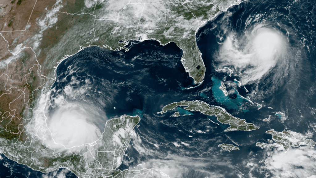
National Hurricane Center forecasters are closely monitoring the progress of Hurricane Grace, located about 155 miles northeast of Veracruz, Mexico, Tropical Storm Henri, located over the southwestern Atlantic, about 320 miles south-southeast of Cape Hatteras, North Carolina and a new area of disturbed weather located over the far eastern Atlantic. No other features are in place at the current time.
NOAA/Colorado State University/ RAMMB 08/20/21 12:20 pm CDT
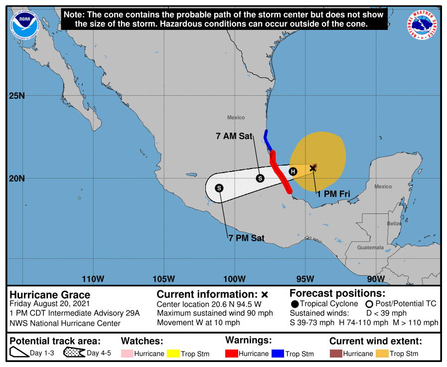
As of 1 pm CDT, the center of Hurricane Grace was located over the southern Gulf of Mexico Grace and moving toward the west near 10 mph. This general motion at a slightly slower forward speed is expected during the next day or so. On the forecast track, the center of Grace is forecast to move across the southwestern Gulf of Mexico this afternoon, and then make landfall along the coast of mainland Mexico within the hurricane warning area this evening or tonight. Data from an Air Force Reserve Hurricane Hunter aircraft indicated maximum sustained winds are near 90 mph with higher gusts. Strengthening is forecast until Grace makes landfall tonight, with rapid weakening expected as Grace moves inland over the mountains of central Mexico.
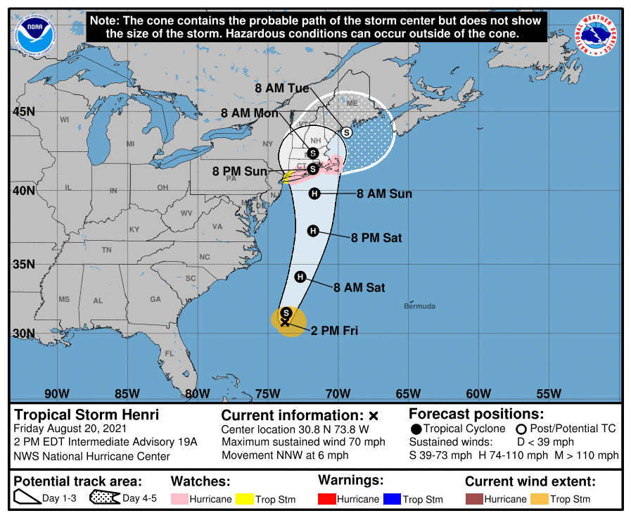
As of 1 pm CDT, the center of Tropical Storm Henri was located over the southwestern Atlantic between Bermuda and Florida. Henri is moving toward the northwest near 6 mph. A turn toward the north is expected by tonight, and Henri is forecast to accelerate in that direction through early Sunday. On the forecast track, Henri is expected to make landfall in southern New England by late Sunday. Maximum sustained winds have increased to near 70 mph with higher gusts. Additional strengthening is forecast during the next couple of days, and Henri is expected to become a hurricane by Saturday and be at or near hurricane strength when it makes landfall in southern New England.
Out over the eastern Atlantic, a tropical wave was located several hundred miles to the southwest of the Cabo Verde Islands. This system is producing a broad area of disorganized showers and thunderstorms. This tropical wave is expected to interact with another wave emerging off the African coast over the next day or two. Afterwards, environmental conditions appear marginally favorable for some slow tropical development by the beginning of next week as this system moves gradually to the northwest our over the open Atlantic at 5 to 10 mph. NHC forecasters are giving this system a low chance (20 percent chance) for tropical development over the next 5 days.
A Good Weekend to Catch the Planets Venus and Jupiter
Jupiter and Saturn shine in the southeast in late twilight and after dark. They’re magnitudes –2.9 and +0.2, respectively, in Capricornus. Friday evening, the bright Moon shines under Saturn, and Jupiter shines to their left. Saturday and Sunday nights, the full Moon will shine under Jupiter, with Saturn to their right.
Jupiter starts the night lowest. Saturn glows 18° (about two fists) to Jupiter’s upper right. The pair levels out around 11 p.m. daylight-saving time. By then they’re about at their highest in the south, at their telescopic best. Both planets reached opposition this month, so the two planets are at their closest, biggest, and brightest of the year.
Have good weekend.
Bob
Social Media