Oppressive heat is going to be the main story over the next week as the first true heat wave of the summer takes shape this weekend and continues through late next week. The culprit for this heat wave is a strong ridge of high pressure in the middle and upper atmosphere–a familiar feature to our region over the summer months . Friday’s analysis showed the ridge covering the southwestern and south central U.S., with the ridge being centered over southwestern New Mexico. The ridge is not only blocking any storms from moving over our area but it is also producing a very dry and stable atmosphere across our region. Sinking air from the middle atmosphere and a very hot July sun will combine to produce very hot afternoon temperatures. Forecasts call for the ridge to grow even stronger this weekend. At the same time, an area of very hot air is forecast to spread into Texas from the interior of Mexico. The result will be the development of a sunny, dry and very hot weather pattern, with the very hottest temperatures expected to occur Sunday and Monday. Slightly lower but still very hot temperatures look to continue Tuesday through Friday. Here is how I expect the temperature pattern to shape up:
- Friday afternoon: High temperatures near 98-101 across the Hill Country and Central Texas regions. Highs in the mid and upper 90s coastal plains.
- Saturday: High temperatures near 99-102 degrees across the Hill Country and Central Texas regions. Highs near 98-100 coastal plains.
- Sunday and Monday: High temperatures near 105-109 across the western and northern Hill Country and near 103-107 across the eastern Hill Country and Central Texas regions. Highs near 100-102 coastal plains.
- Tuesday: High temperatures near 103-107 degrees across the western and northern Hill Country and near 101-104 degrees eastern Hill Country and Central Texas regions. Highs near 98-100 degrees coastal plains.
- Wednesday: High temperatures near 101-103 degrees across the western and northern Hill Country and near 99-102 degrees eastern Country and Central Texas regions. Highs near 95-98 degrees coastal plains.
- Thursday: High temperatures near 99-102 degrees across the western and northern Hill Country and near 98-101 degrees eastern Hill Country and Central Texas regions. Highs in the mid-90s coastal plains.
High humidity levels Friday afternoon and Saturday across the eastern counties of Central Texas and the coastal plains region will combine with the very hot temperatures to produce very dangerous heat index readings between 105 and 110 degrees. Drier air, lower relative humidity readings are forecast beginning Sunday, which should bring the heat index readings closer to the actual air temperature.
Heat safety will be an important consideration over the next several days! Drink plenty of fluids, stay in an air-conditioned room as much as possible, stay out of the sun and check on relatives and neighbors. Young children and pets should never be left unattended in vehicles under any circumstances! Take extra precautions if you work or spend time outside. When possible, reschedule strenuous activities to the early morning or evening.
Sunny, dry and not quite as hot weather is forecast next Friday and next weekend. High temperatures are forecast to be mostly in the upper 90s, with mid-90s expected towards the coast.
Just some minor changes to the hot and dry pattern are forecast during the week of July 20th. Forecasts call for the center of the high pressure ridge to shift north to Kansas and Nebraska, while the ridge itself will stretch from California to the Mid-Atlantic. With the center of the ridge pulling that far to our north, it will open the door for some clouds and moisture to spread inland from the Gulf, possibly resulting in isolated to a few scattered rain showers across the area. High temperatures are predicted to be in the upper 90s.
Tropical Weather Outlook
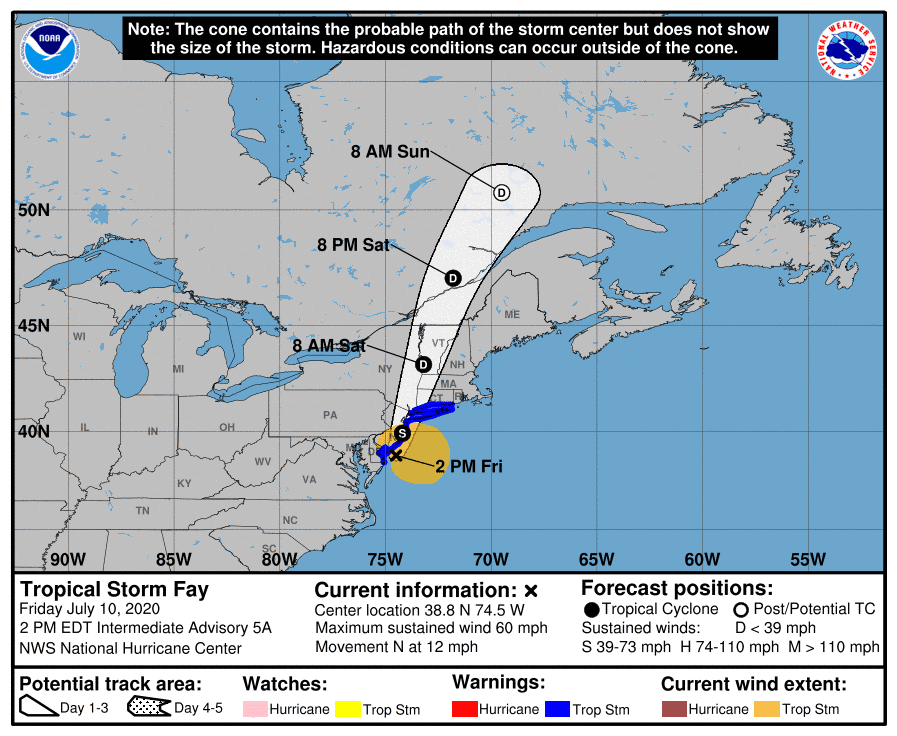
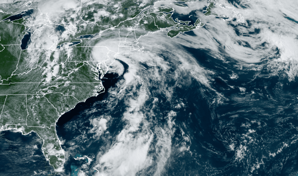
A strong area of low pressure pushing offshore of the Carolinas Thursday strengthened into a tropical storm named Fay— the 6th named storm of the hurricane season. (Fay has beat the previous record for earliest formation of the season’s sixth storm – and also the fifth storm!).
As of 10 am CDT, the center of Tropical Storm Fay was located by an Air Force Reserve Hurricane Hunter aircraft about 40 miles south-southeast of Cape May, New Jersey or 170 miles south of New York City. Fay is moving toward the north near 12 mph. A northward to north-northeastward motion at a faster forward speed is expected over the next couple of days. On the forecast track, the center of Fay is forecast to move near the mid-Atlantic coast this afternoon and evening and move inland over the mid-Atlantic and northeast United States tonight and Saturday.
Data from the aircraft indicate that maximum sustained winds are near 60 mph with higher gusts. Little change in strength is forecast today while the center remains over water. Weakening should begin after the center moves inland, and Fay is expected to weaken to a tropical depression by early Saturday.


RAMMB-CIRA 07/10/20 1:50 pm CDT
Elsewhere, weather conditions are quiet and tropical cyclone development is not expected for the next 5 days.
Comet NEOWISE Update
Comet NEOWISE is appearing now as a barely naked eye object, low in the morning sky. It is dimly visible to the naked eye, while binoculars do a better job bringing it into view. As of Saturday morning July 11th it is expected to be about magnitude 2 or 3, with the comet located just above the northeastern horizon and quite difficult to view. The best viewing time will be about 1.5-2 hours before sunrise.
But beginning Tuesday, July 14th, the comet’s best visibility will switch from dawn to dusk. It will be visible low in the north-northwest sky around the end of twilight. Look far below the Big Dipper, which is hanging by its handle high in the northwest, and a little to the right. The comet should be visible in the evening sky through the end of summer.
Between July 12–18 you can observe it in both pre-dawn and evening skies. And depending on the darkness of your sky, you might be able to see the comet without any optical aid, but binoculars will certainly bring the comet into view.
You can find sky maps to help you find and view the comet at Spaceweather.com
Have a good weekend and stay cool!
Bob


Social Media