Observations indicate La Niña strengthened during October, with a large tongue of well below-average sea surface temperatures (SSTs) now extending from the Date Line to the eastern Pacific Ocean. The October sea surface temperature anomaly (departure from the long-term average) in the Niño 3.4 region of tropical Pacific was -1.3°C according to the ERSSTv5 dataset, substantially cooler than the La Niña threshold of -0.5°C. According to the Climate Prediction Center, this was the eighth-strongest negative October value in the ERSSTv5 record, which dates back to 1950.
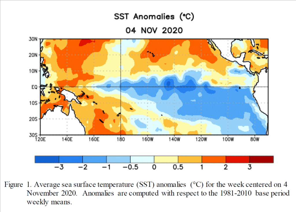
Recent observations indicate atmospheric circulation anomalies over the tropical Pacific Ocean remain consistent with La Niña. Low-level wind anomalies are easterly across most of the tropical Pacific and they actually strengthened during October. Upper-level westerly wind anomalies expanded over most of the tropical Pacific indicating the atmospheric/oceanic La Nina coupling was strong. Tropical convection continued to be suppressed from the western Pacific to the Date Line, and enhanced convection remained over Indonesia. Overall conditions show a well-developed La Niña is now locked in place.
Scientists pay considerable attention to La Niña and El Niño because it affects global weather and climate; a stronger La Niña event means these effects are more likely. We’ve already seen hints of some of the weather and climate patterns we’d expect during La Niña. The most obvious one of these is the extraordinarily active Atlantic hurricane season. La Niña leads to reduced shear (the change in wind from the surface to the upper levels) in the atmosphere over the Atlantic, allowing hurricanes to grow and strengthen.
Although October was a little early for clear La Niña impacts, global precipitation and temperature patterns during the month did give some hints of a La Niña effect, including more rain in Indonesia, drier conditions in southeastern China and the Southwestern U.S. plus Texas and cooler weather in Canada and into the U.S. Northern Plains.
A majority of the latest forecast solutions predict La Niña (Niño-3.4 index less than -0.5°C) will persist through the upcoming Northern Hemisphere winter, then weaken during the spring. Several models suggest this will be a strong La Niña event (Niño-3.4 index values lower than -1.5°C) during the peak November-January season. The CPC forecaster consensus supports this view in light of the significant atmosphere-ocean coupling already in place.
CPC forecasters call for an ~95% chance for La Niña to continue January-March and an ~65% chance for La Niña to continue March-May.
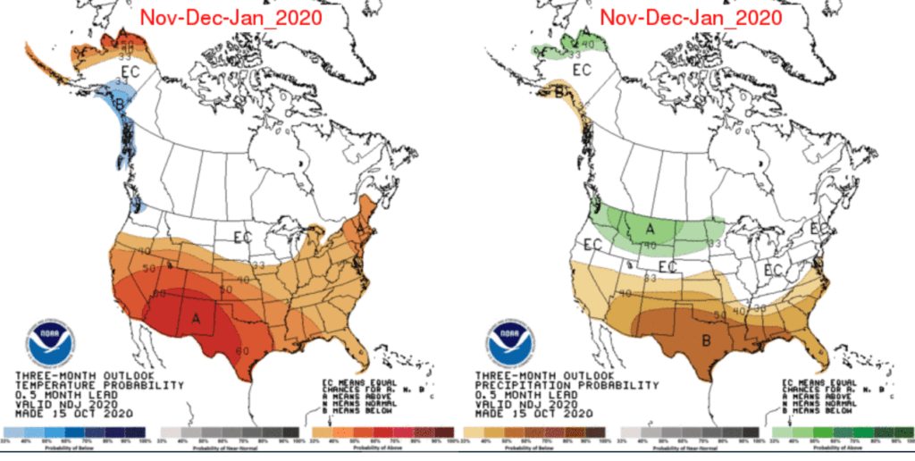
La Nina’s, especially strong La Nina’s, tend to have a strong drier-than normal and milder-than normal influence on fall and winter weather across Texas. The latest CPC temperature and precipitation outlook through January shows increased odds temperatures will milder than normal and rainfall will be lower than normal across all of Texas.
Bob
Social Media