Sunny and quiet weather is in place across the region as we start off the new week. Monday morning started off chilly, with low temperatures in the 30s and 40s. According to LCRA’s Hydromet, lows were a mixture of low to upper 30s across the Hill Country, mid to upper 30s across Central Texas and low to mid-40s across the coastal plains. The lowest recorded temperature was 28 degrees. This reading was observed at gauges located in southeastern Llano County, near and just north of Lake Brownwood and also between Junction and Menard. In Austin, the low temperature at Camp Mabry was 45 degrees and the low at Austin-Bergstrom Airport was 36 degrees.
Monday’s weather maps showed a broad, stable ridge of high pressure spreading over Texas out of the Southwestern U.S. This feature is forecast to remain over Texas through late week, causing more dry and stable weather. At the surface, a dome of Canadian high pressure currently covers Texas and the Lower Mississippi Valley. The high is predicted to slide off to the east late this afternoon and tonight, bringing a return of southerly breezes and warmer temperatures. Relative humidity levels are forecast to increase mid to late week as moisture spreads inland from the Gulf.
For this afternoon and tonight, expect a clear sky. This afternoon’s temperature is forecast to warm to the low 70s. Lows Tuesday morning will generally be in the low and mid-40s. Expect a light south and southwesterly breeze at 5-10 mph. Do note some fog will be possible across the coastal plains region toward daybreak Tuesday.
For Tuesday through Friday, dry, quiet and warmer weather is forecast. A weak wave of low pressure passing north of our region late Tuesday is expected to bring widespread mid and high-level clouds. Otherwise, expect a pattern of mostly sunny afternoons and a cloudy sky overnight. Areas of fog are forecast across the coastal plains and parts of Central Texas Wednesday and Thursday mornings. High temperatures Tuesday and Wednesday will be in the mid-70s, warming to the upper 70s Thursday and to near 78-80 degrees Friday. Lows Wednesday morning will generally be in the upper 40s to low 50s. Lows Thursday and Friday mornings will range from around 50-52 degrees across the Hill Country, to near 58-60 degrees near the coast.
The weather pattern is forecast to trend a bit more unsettled this weekend when the ridge over Texas weakens and a wave of low pressure slides southeast out of the southern Rockies. There is still some uncertainty amongst the various forecast solutions regarding the timing of this wave of low pressure. However, ensemble solutions call for the wave to move across Texas Saturday into Saturday night, exiting to the east on Sunday. Based on this timing, I expect a slight chance for light showers to develop Friday night, followed by a 30-40 percent chance for rain showers and isolated thunderstorms Saturday and Saturday night. The chance for rain should diminish from west to east Sunday morning as the wave exits to the east. Weekend temperatures will be mild, with highs in the low 70s and lows in the 50s.
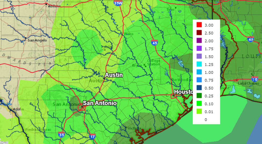
Rain amounts are not expected to be very heavy—generally around a tenth of an inch across the Hill Country, and around a quarter inch across Central Texas, and between a quarter and a half inch across the middle Texas coast.
NWS Rainfall Outlook for the Period 6 pm Monday through 6 pm Next Monday:
The outlook for next week calls for partly cloudy, dry and mild weather next Monday and Tuesday. Expect highs in the low and mid-70s, with lows in the 50s. A weak cold front is predicted to move across the area next Wednesday, causing a slight chance for showers. Dry and slightly cooler air will follow next Thursday and Friday, with highs around 70 degrees and lows around 48-50 degrees.
No unusually cold, or freezing temperatures are on the horizon for at least the next two weeks.
Tropical Weather Outlook
Weather conditions are quiet across the tropical Atlantic and tropical cyclone formation is not expected. The 2021 Atlantic Hurricane Season will officially come to a close Tuesday.
An Update on Venus, Jupiter and Saturn
The planet Venus is shing at a dazzling magnitude –4.9! Look for it in the southwestern sky during and after twilight. Venus has reached its greatest height and greatest brilliancy for this fall.
The planets Jupiter and Saturn, shine in the south to southwest during evening, far to the upper left of Venus. Jupiter is the bright one at magnitude –2.3. Saturn, 16° to Jupiter’s lower right, is at magnitude +0.7, only 1/16 as bright. Saturn sets around 9 p.m. Jupiter sets a little more than an hour later.
Have a good week.
Bob
Social Media