We’ve seen quite a bit of rain falling across the Hill Country and Central Texas regions today. A large area of rain spread southeast over the Hill Country earlier this morning, producing widespread totals between a quarter inch and 3 inches. The most concentrated area of rain occurred across the northern Hill Country, over Brown, Coleman, Mills and San Saba Counties where several LCRA gauges recorded between 2 and 3 inches of rain. Across Central Texas, widespread moderate to occasionally heavy rain spread over much of Bastrop, Travis, Caldwell, Hays, and Williamson Counties beginning early this afternoon. As of 2 pm, totals across these counties have generally been between 0.5 and 2 inches, with a few isolated totals to near 3 inches. Totals across the coastal plains have been considerably lower.
Today’s rains are being generated by a trough of low pressure moving southeast out of northwest Texas, and a weak trough of low pressure located just off the middle and upper Texas coast. Both features are pulling considerable moisture north from the Gulf of Mexico and generating areas of slow-moving moderate to heavy rain and occasional thunderstorms.
High-resolution forecasts call for showers and thunderstorms to continue across the region this afternoon and early evening, with the most concentrated area of rain predicted to occur across Central Texas and the eastern Hill Country. The rain may at times be heavy, producing large amounts of rain in a short period of time. These types of rainfall rates could produce a few spots of quick flooding, especially in low water crossings and urban areas. Additional totals of 1-2 inches will be possible across parts of Central Texas. For the rest of the region, totals through early Wednesday morning are forecast to average less than a half inch. Forecasts call for most of the rain to taper off this evening, with just a 20-30 percent chance for scattered rain showers expected overnight.
The outlook for Wednesday and Thursday calls for more showers and scattered thunderstorms across the region as considerable moisture remains in place across Texas. However, the coverage of the rain is expected to be less than what we have seen today. The probability for rain both days will generally be around 60-70 percent. Rain totals of 0.5-1 inch are forecast, with isolated totals to near 3 inches will be possible. The most favorable area for rain is predicted to be across the Hill Country.
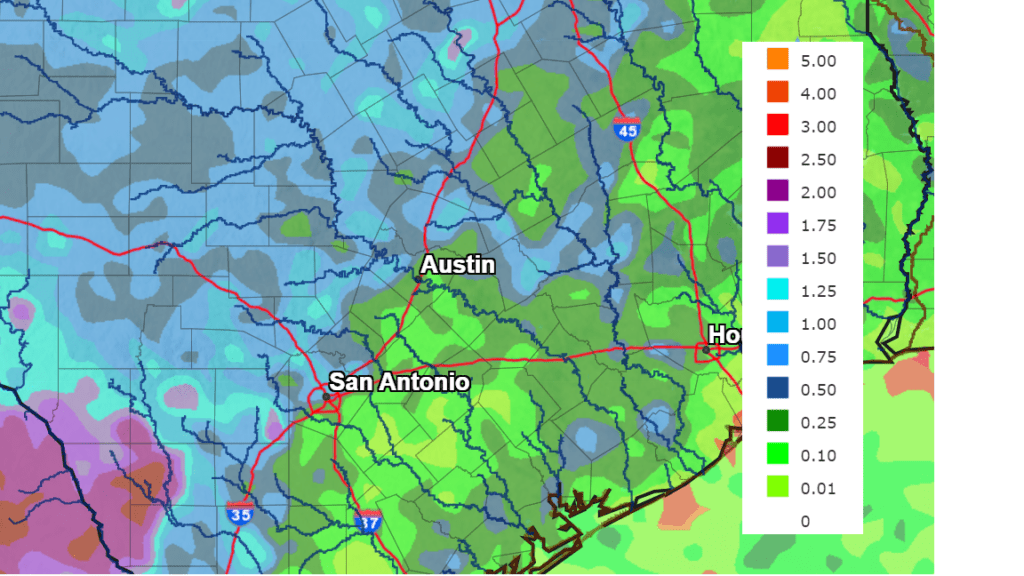
National Weather Service Rain Forecast for the period 7 pm Tuesday through 7 pm Thursday:
The wet pattern is not showing any signs of breaking down late week and through the holiday weekend. Waves of low pressure moving across the area and a very moist atmosphere will cause periods of showers and scattered thunderstorms Friday through Monday. But we’ll see some breaks in the rain develop as well. The probability for rain each day is predicted to be near 40-50 percent. Additional totals of 1-2 inches will be possible over 4-day period.
High temperatures Wednesday and through the weekend are forecast to be around 88-90 degrees.
Bob
Social Media