…A Winter Storm Warning has been posted for all of the Hill Country, the Austin metro area, the Interstate 35 Corridor, plus Bastrop, Caldwell and Lee counties beginning 3 am Thursday, continuing through 6 pm Thursday…
…A Winter Weather Advisory has been posted for parts of Southeast Texas, including Fayette, Colorado and Wharton counties, from 6 am Thursday through 9 am Friday…
Confidence is now high that a significant icing event will take place across the Hill Country, the Austin metro area, and the Interstate-35 corridor, from New Braunfels to Georgetown on Thursday. Wintery weather is also forecast to occur over the area east of Interstate 35, extending south to roughly the U.S. 59 Highway corridor (Interstate 69).
Cold air is spilling into Central Texas a little faster than was previously forecast. As of midday, the arctic cold front has pushed just east of Interstate 35. Temperatures have fallen into the 40s across the Hill Country, into the low and mid-30s between Brownwood and Abilene, and into the 20s across the Panhandle region. The cold front is forecast to continue sinking southeast this afternoon and should push off the middle Texas coast this evening. As of midday, Doppler radar showed a widespread area of rain and scattered thunderstorms covering much of West and Northwest Texas. Showers were quickly spreading east into the Hill Country. For this afternoon, expect a good chance for rain showers and scattered thunderstorms across the entire region as moisture increases ahead of an approaching trough of low pressure. Northerly winds will increase to 10-20 mph behind the cold front. Look for temperatures to fall into the 30s across the Hill Country and into the 40s across Central Texas. Meanwhile, coastal locations will see temperatures in the low and mid-70s.
Although the cold front is moving through our area this afternoon, the main push of very cold air is expected to take place tonight through Thursday morning. Strong northerly winds, gusting to around 30 mph, will produce very cold wind chill values on Thursday into the single digits and teens. Temperatures around sunrise Thursday are forecast to be in the low 20s across the Hill Country, the upper 20s in the Austin area, and the mid and upper 30s for areas east of Interstate 35.
Light precipitation is predicted to continue across the region tonight through Thursday with the trough still located to our west. Through most of Wednesday night, most of the precipitation should mainly be a cold rain. Forecasts call for the freezing line to reaching the northern Hill Country between midnight and 3 am Thursday, shift to the northern portions of the I-35 corridor around Austin between 5 am and 7 am, then move south to a San Antonio to La Grange line from about 8 am to 11 am Thursday morning. A transition from rain to freezing rain can be expected to take place around these times. The precipitation is forecast to change over to a mixture of freezing rain and sleet late morning through Thursday afternoon. The precipitation is forecast to end from west to east late Thursday afternoon into Thursday evening.
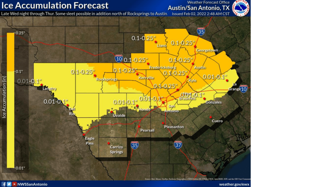
Significant ice accumulation is forecast to occur across the Winter Storm Warned area (the Hill Country, Austin and the Intestate 35 corridor) on Thursday. Widespread 1/10 to 1/4 inch of ice accretion is forecast across the Hill Country and along with the Interstate 35 corridor, from the north side of San Antonio through Austin and Georgetown, and east into Bastrop and Lee counties. Do note, some pockets of 1/4 to 1/2 inch ice accretions will be possible through the Hill Country and western Hays, Travis, and Williamson counties. For areas east of Interstate 35 in the Winter Weather Advisory, ice accumulations up to a tenth of an inch are forecast. Due to the forecast for accumulating ice, travel Thursday could be very difficult and hazardous on untreated roads, especially elevated bridges, overpasses, and roadways across the Hill Country and Austin metro area. Pavement could be slippery to walk on. Some minor travel impacts are forecast for areas east of Interstate 35. For the northern Hill Country region between San Saba, Brownwood and Brady, expect snow and sleet accumulation up to 1 inch, with ice accumulation of less than 1/4 of an inch.
A mostly cloudy sky with bitterly cold temperatures is forecast Thursday night. Lows Friday morning will include the low and mid-teens across the Hill Country, near 20-22 degrees across Central Texas and the mid-20s across the coastal plains. Keep in mind some icing impacts may linger Thursday night into Friday morning long after the precipitation ends due to the very cold temperatures.
Sunny and dry weather is forecast Friday and through the weekend. More bitterly cold temperatures are forecast Friday night into Saturday morning. Temperatures should trend a little warmer over the weekend, however, freezing temperatures are still forecast each night through Monday night.
This will not be a repeat of the February 2021 winter storm, but protective measures should be taken to help mitigate any potential freeze damage. Make use of the milder temperatures this afternoon to complete any needed preparation actions. Please remember the 4 P`s and protect sensitive People, Pets, Plants, and Pipes.
Bob
Social Media