It has been an unusual start to the month August, with rain showers and scattered thunderstorms spreading across the Hill County and parts of Central Texas. According to LCRA’s Hydromet, several locations have reported totals greater than 2 inches over the past 24 hours. The highest gauged total as 1 pm has been 5.99 inches at a spot in northeastern Travis County, located about 8 miles northwest of Elgin.
All of the rain activity has developed in advance of and along a cold front that is slowly pressing southeast out of North and Northwest Texas. As of 1 pm, the cold front stretched from Longview, to near Austin and Del Rio. The front is forecast to sink south to the middle and upper Texas coast Tuesday, where it is projected to pull up stationary. The best chance for rain is expected to follow the cold front south to the coast tonight through Tuesday as drier and more stable air filters in across the Hill Country.
For this afternoon and tonight, expect periods of rain showers and scattered thunderstorms across the Hill Country and Central Texas regions, with the most concentrated area of rain occurring along and to the south of U.S Highway 290. The probability for rain will be near 70 percent this afternoon, decreasing to 30 percent overnight. Rain amounts through sunrise Tuesday morning are forecast to generally average between 0.25 and 0.50 inches, with isolated totals of 1-2 inches possible. Across the coastal plains region, the probability for rain will be 50 percent this afternoon, increasing to 70 percent this evening and overnight. Here, rain amounts are also predicted to average between 0.5 and 1 inch, with isolated totals of 2-4 inches possible.
Monday’s high temperature is forecast to be in the mid and upper 80s across the Hill Country and Central Texas regions, while reaching the low and mid-90s across the coastal plains.
Tuesday through Wednesday, the best chance for rain showers and scattered thunderstorms is forecast to be across the coastal plains region, in the vicinity of the stalled cold front. The probability for rain both days is forecast to be near 30 percent, with daily rain amounts averaging around a quarter inch. For the Hill Country and Central Texas, expect a partly cloudy to mostly sunny sky, with just a slight chance for a few isolated showers. Rain amounts, if any, should total around a tenth of an inch.
High temperatures Tuesday and Wednesday are predicted to generally be in the low 90s.
For Thursday, the chance for rain and thunderstorms will increase to around 30 percent across the entire region as an atmospheric disturbance tracks south out of Arkansas and eastern Oklahoma. This system is expected to stay far enough to our north and east that only a few showers and thunderstorms can be expected. Rain amounts, if any, should total around a quarter inch. Expect a mostly sunny to partly cloudy sky, with high temperatures in the low to mid-90s.
Friday and through next weekend, this week’s stalled cold front is forecast to lift back to the north as a warm front. Meanwhile, a weak ridge of high pressure in the upper atmosphere is forecast to strengthen over the southern plains and the southeastern U.S., causing a generally dry, sunny and warmer weather pattern.
High temperatures are predicted to be in the mid-90s Friday, warming to the upper 90s for Saturday and Sunday.
The outlook for next week calls for mostly sunny, dry and hot weather. A broad ridge of high pressure in the upper atmosphere is forecast to cover the central and eastern U.S. through the period. The coastal area could see a few spotty daily showers while the rest of the region should stay dry. High temperatures next week are forecast to hold mostly in the upper 90s. The latest forecasts don’t show the heat ridge setting up directly over Texas in the next couple of weeks.
Tropical Weather Outlook
Weather conditions remain quiet across the majority of the tropical Atlantic, the Caribbean Sea and the Gulf of Mexico.
National Hurricane Center forecasters are monitoring a disorganized area of showers and thunderstorms associated with a surface trough of low pressure over the far eastern Atlantic, a few hundred miles south of the Cabo Verde Islands. NHC forecasters are calling for a slight chance for tropical development of this system during the next couple of days, while it moves northward or northwestward. The system is forecast to move over cool waters by Thursday, which should cause the system to dissipate. NHC forecasters are giving this system a low chance (a 20 percent chance) for tropical development over the next 5 days.
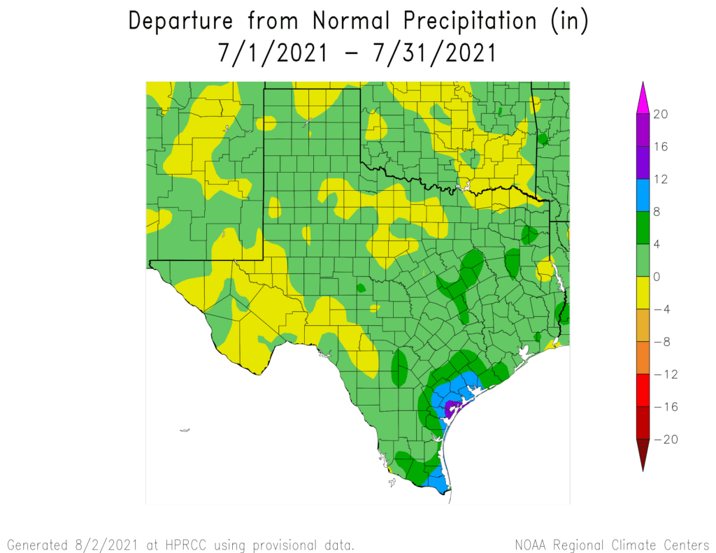
A Cooler and Wetter than-Normal July
The month of July featured cooler than-normal and wetter than-normal conditions. Temperatures generally averaged between 2 and 3 degrees below normal across the Hill Country and Central Texas and between 1 and 2 degrees below normal across the middle Texas coast. Rainfall averaged 1-2 inches above normal across the Hill Country and Central Texas and more than 4 inches above normal across the middle Texas coast.
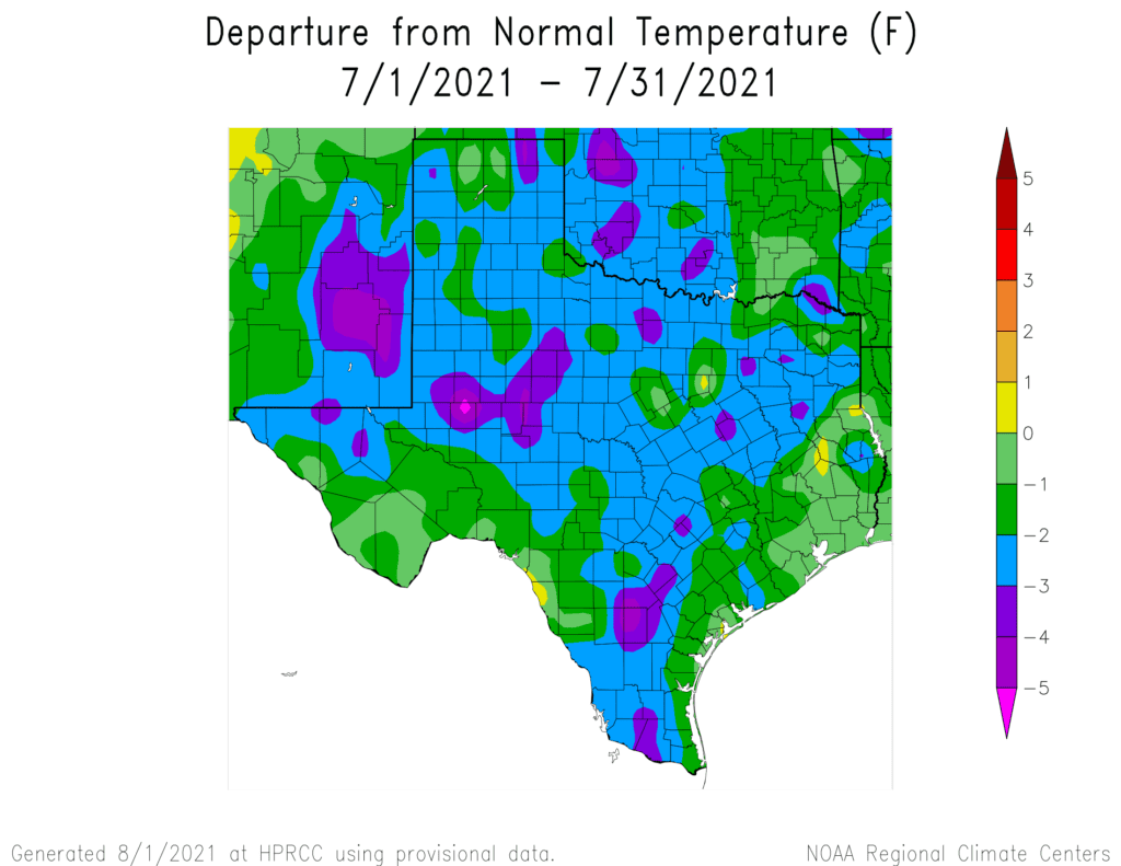
In Austin at Camp Mabry, the temperature averaged 84.1 degrees, which was 1.7 degrees below normal. July 2021 tied with July 1959 and July 1947 for the 48th coolest July on record. Rainfall totaled 4.05 inches, which was 2.09 inches above normal. July 2021 ranks as the 17th wettest July on record. July contained only one day with the temperature at or above 100 degrees. The last time Camp Mabry recorded just one 100-degree day in July was back in July 1988. Do note most recently, July of 2010, 2007, 2004, 2002 and 1997 had zero 100 degree days in the month of July, while July 2011 contained 29 days.
At Austin-Bergstrom, the temperature averaged 80.8 degrees, which was 3.7 degrees below normal. July 2021 ranks as the third coolest July on record, behind July and July 2000. Rainfall totaled 2.82 inches, which was 0.66 inches above normal. July 2021 ranks as the 17th wettest July on record. July contained zero days with the temperature at or above 100 degrees. The last time Austin-Bergstrom recorded zero 100 degree days in July was back in July of 2010. Zero days were also recorded most recently in 2007, 2004, 2003, 2002 and 1999. Interestingly, the hottest temperature recorded at Austin-Bergstrom so far this summer has been 96 degrees on June 13 and 14 and August 1st.
Bob
Social Media