Memorial Day weekend weather felt more like the Fourth of July rather than late May. High temperatures were generally in the mid and upper 90s and there was surprisingly no rain. Tuesday’s weather maps showed a broad ridge of high pressure in the upper atmosphere stretching from northern Mexico and southern Texas, to the northeastern U.S. To the west of the ridge, a large trough of low pressure covers much of the western U.S. and the northern Plains states. This western trough/eastern ridge configuration is predicted to hold through Wednesday, causing continued summer-like weather conditions across Central and South Texas. Late night and early morning low clouds Wednesday, will give way to a mostly sunny sky in the afternoon.
- High temperatures Tuesday and Wednesday will include the mid and upper 90s across the Hill Country and Central Texas regions, and mid-90s across the coastal plains.
Small changes in the weather are forecast to take place across the region Thursday through Friday when the western trough lifts to the northeast, allowing a weak cold front to push south into Texas. The front is forecast to sag south of the Red River Wednesday night, reaching a position over the Concho Valley and North Central Texas Thursday morning. Forecasts call for the cold front to sink south and stall across Central Texas Thursday night into Friday morning. Weak forcing along the cold front is expected to cause the development of scattered rain showers and isolated thunderstorms over parts of the Hill Country and Central Texas regions Thursday afternoon through Friday afternoon. Unfortunately, a widespread and soaking rain is not expected. The rain will likely be more hit and miss, with the probability for rain at any given location around 20-30 percent. Do note a couple of the thunderstorms Thursday and Friday afternoons could be strong, producing some very gusty winds. Rain amounts are predicted to average less than a quarter inch. Many locations, including the coastal plains region, are forecast to stay rain-free.
Drier and slightly cooler air behind the cold front is expected to cause less hot temperatures on Thursday and Friday. Under a mostly sunny to partly cloudy sky, high temperatures both days are forecast to generally be around 90-92 degrees.
The cold front is predicted to lift back to the north early Saturday, ending the slight chance for rain. At the same time, high pressure in the upper atmosphere over Mexico is forecast to begin spreading north across Texas, causing a return to middle of summer-like weather conditions.
- High temperatures Saturday will include the upper 90s across the Hill Country, the mid and upper 90s across Central Texas, and low to mid-90s across the coastal plains.
- High temperatures Sunday are predicted to be close to 100 degrees across the Hill Country, be in the upper 90s across Central Texas, and in the mid-90s towards the coast.
Some of the hottest temperatures so far this summer are predicted for the entire region next week as the ridge of high pressure over Mexico spreads across Texas and strengthens. Sunny and very hot weather is forecast Monday through Friday. Fortunately, breezy conditions are expected to continue.
- Daily high temperatures are forecast to be near 100-105 degrees across the Hill Country, near 100-102 degrees across Central Texas, and in the upper 90s across the coastal plains region.
Long-range forecasts call for the very hot temperatures to continue into the following weekend. There are some signs the ridge will begin to weaken the week of June 13th.
Tropical Weather Outlook
A large and complex area of low pressure is expected to develop near the Yucatan Peninsula and the northwestern Caribbean Sea in a couple of days, partially related to the remnants of Agatha from the eastern Pacific. Despite strong upper-level winds over the area, this system is likely to become a tropical depression while it moves northeastward over the northwestern Caribbean Sea and southeastern Gulf of Mexico late Thursday or Friday. Regardless of development, locally heavy rainfall is likely across portions of southeastern Mexico, the Yucatan Peninsula, Guatemala, and Belize during the next couple of days, spreading across western Cuba, southern Florida, and the Florida Keys on Friday and Saturday.
NHC forecasters are giving this area of disturbed weather a 30 percent chance for tropical development over the next 48 hours, and a 70 percent chance for tropical development over the next 5 days.
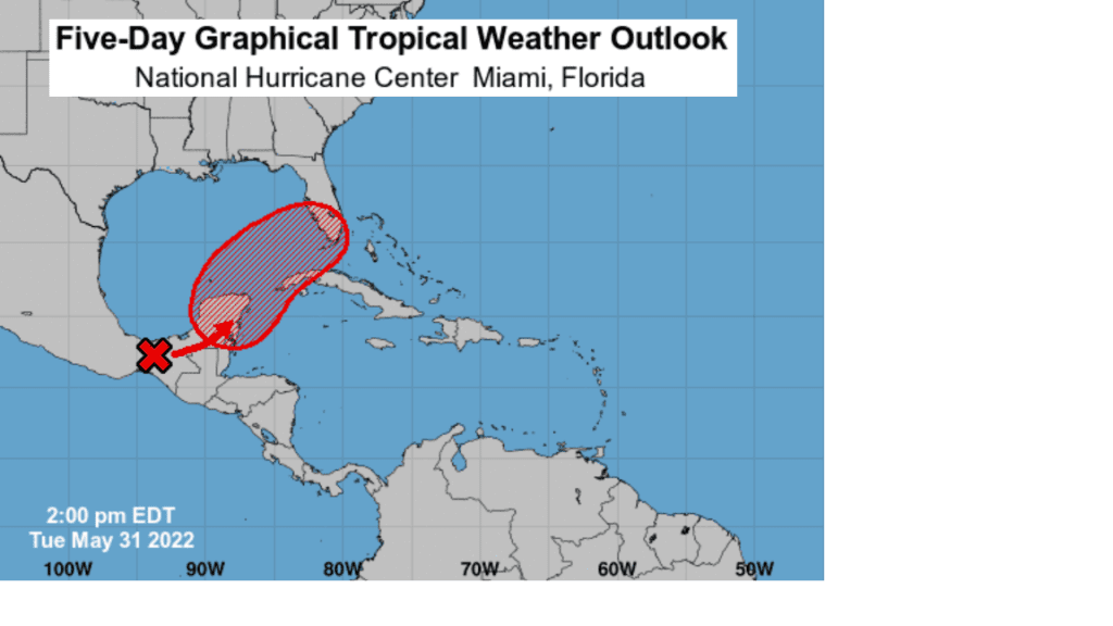
Weather conditions across the remainder of the tropical Atlantic are quiet and tropical cyclone development is not expected over the next 5 days.
One of the Hottest Mays on Record
As we close out the month of May, data through the 30th indicates this month will likely close as one of the hottest, if not THE hottest, Mays on record. Austin, San Antonio, and Victoria are guaranteed to have their warmest May on record. Both Corpus Christi and Houston will likely have their 2nd warmest May on record. The DFW area will likely end up as the 5th or 6th hottest. Preliminary state-wide data indicates May 2022 could indeed end up being the hottest May on record for Texas.
Have a good week!
Bob
Social Media