Although the calendar says September, August-like temperatures are expected to be with us through the holiday weekend and most of next week. The summer-time heat dome that set up across the western for most of the summer, migrated to the southern Plains states earlier this week, causing temperatures locally to spike into the upper 90s. Friday’s weather maps showed a broad ridge of high pressure in the upper atmosphere covering the south central and southeastern U.S., with the ridge being centered over Oklahoma. The ridge is predicted to cause more very hot temperatures through the weekend. Forecasts call for the ridge to remain over our area through the weekend, then relocate to the western U.S. for most of next week. Despite the new location, temperatures are still forecast to remain hot throughout next week.
This afternoon, scattered rain showers are forecast across the coastal plains and over the area east of Interstate 35 as a small plume of tropical moisture spreads inland off the Gulf. The probability for rain will range from 50 percent across the coastal plains to just 20 percent for locations north of Interstate 10. Spotty totals of 0.25-0.5 inches are forecast. Isolated total of 1-1.5 inches will be possible. For the Hill Country and I-35 corridor, this afternoon’s weather will be most sunny and hot. High temperatures will generally be in the mid and upper 90s.
Saturday through Sunday, weather conditions are forecast to be mostly sunny, dry and hot. A couple of spotty showers will be possible towards the coast, but areal coverage is expected to be low. High temperatures are predicted to generally be near 98-100 degrees.
For Labor Day and Tuesday, scattered, mainly afternoon rain showers and thunderstorms are forecast across the region as a weak cold front sinks south out of the southern Plains and stalls somewhere across North Texas. Showers are predicted to develop along the front and track to the south. The probability for rain both days is forecast to be near 30 percent. For locations that happen to see rain, totals will average around a quarter inch or less. High temperatures Monday and Tuesday are forecast to be in the mid and upper 90s.
Next Wednesday through Friday, weather conditions are forecast to trend back to generally dry, sunny and hot, although spotty afternoon showers look to continue across the coastal plains. Expect high temperatures in the mid and upper 90s. But do note forecasters are closely monitoring an area of disorganized showers and thunderstorms over Central America that is predicted to move over the Bay of Campeche late this weekend and early next week. Upper level winds initially look unfavorable for tropical development when this system moves back over water. Regardless of development, a large pool of tropical moisture in the southern Gulf this weekend could spread northward towards Texas late next week.
Aside from this feature, no major changes in the weather pattern are expected looking out into next weekend or the week of September 13th. High temperatures are forecast to slide continue mostly in the mid and upper 90s. Unfortunately, there are currently no signs of our first good fall cold front showing up over the next two-week period.
Tropical Weather Outlook
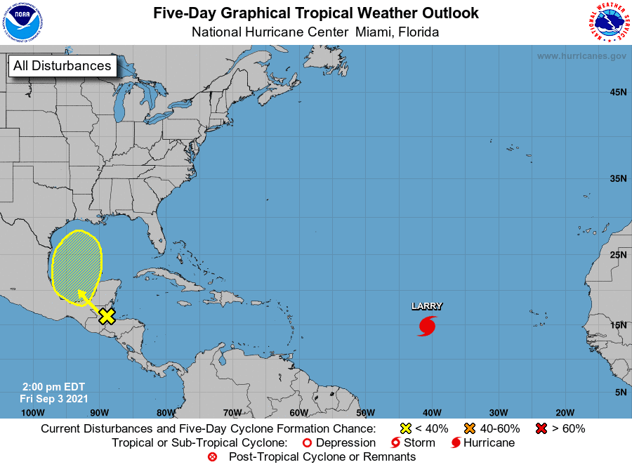
Hurricane Larry was located Friday morning over the central tropical Atlantic, about 1400 miles east of the Lesser Antilles. Top winds were near 90 mph. Larry is moving to the west-northwest in the direction of Bermuda and poses no threat to the Gulf of Mexico.
And as mentioned earlier, a surface trough over the Gulf of Honduras and portions of Central America is producing disorganized shower and thunderstorm activity. This system is expected to move west-northwestward across Central America and the Yucatan Peninsula, bringing heavy rains to that area during the next couple of days. The disturbance is expected to move over the southwestern Gulf of Mexico late this weekend, but unfavorable upper-level winds could limit significant development while the system moves northwestward or northward over the western Gulf of Mexico early next week. NHC forecasters are giving this system a low chance (a 30 percent chance) for tropical development over the next 5 days.
Have a safe and relaxing holiday weekend.
Bob
Social Media