Hot, summertime weather conditions will be in place all week as our region remains under the influence of a weak ridge of high pressure in the upper atmosphere. To our east, Tropical Storm Ida is slowly spreading from Mississippi into Tennessee. Meanwhile to our west, the remnants of eastern Pacific Tropical Storm Nora are spreading north across western Mexico into the Southwestern U.S. Neither of these features are expected to have any impact on our region’s weather. For Central and South Texas, the biggest weather-maker this week will be an area of lingering tropical moisture leftover from late last week and last weekend. This moisture, combined with strong heating, is expected to cause the development of scattered to isolated rain showers and thunderstorms primarily this afternoon and Tuesday.

NOAA/Colorado State University/RAMMB 08/30/21 1:40 pm CDT
The probability for rain is forecast to be near 30 percent across the region this afternoon and again Tuesday afternoon. For locations that do happen to see rain, totals are predicted to average between a quarter and a half inch, with isolated heavier totals. High temperatures today and Tuesday are forecast to reach the mid to upper 90s.
For Wednesday and Thursday, the probability for rain looks to fall to just 20 percent across the Hill Country and Central Texas regions. But across the coastal region, the chance for rain will increase to near 40 percent both days as an axis of tropical moisture spreads inland from the Gulf. Here, daily rainfall totals are forecast to average around a quarter inch, with isolated heavier totals. High temperatures Wednesday are predicted to be in the upper 90s, falling to the mid-90s on Thursday.
Mostly sunny and generally dry weather is forecast across the region Friday through Sunday. Daily high temperatures are predicted to be mostly in the mid-90s.
The outlook for Labor Day and the first half of next week calls for a somewhat increased chance for rain and thunderstorms as a weak area of low pressure pushes inland out of the Gulf, bringing a zone of tropical moisture. This moisture will cause a 30-40 percent chance for scattered rain showers and thunderstorms, with daily rain amounts between a quarter and a half inch. A slight chance for rain will continue the second half next week. Hot temperatures will be in place, with daily highs mostly in the mid-90s.
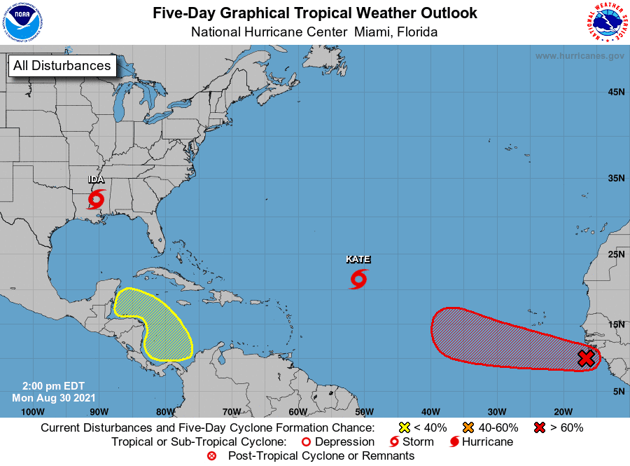
Tropical Weather Outlook
As of 1 pm CDT, Tropical Depression Ida was centered over western Mississippi, roughly 20 miles west-southwest of Jackson. Ida was moving toward the north-northeast near 9 mph and this general motion is forecast to continue today. A faster northeastward motion is expected to begin by tonight and continue through Tuesday night. On the forecast track, the center of Ida will move farther inland over western and central Mississippi this afternoon. Ida is then forecast to move over northeastern Mississippi tonight, across the Tennessee Valley on Tuesday and near the central Appalachians on Wednesday. Maximum sustained winds were near 40 mph with higher gusts. Weakening is forecast during the next day or so, and Ida is expected to become a tropical depression later this afternoon.
The tropical depression over the central Tropical Atlantic strengthened into Tropical Storm Kate earlier today. As of 10 am CDT, Kate was located about 770 miles east-northeast of the Leeward Islands. Kate was moving toward the north near 8 mph. A general northward motion is expected to continue through Tuesday, followed by a turn to the northwest on Tuesday night or Wednesday. Satellite-derived wind data indicate that maximum sustained winds are near 45 mph with higher gusts. Some fluctuations in intensity are possible during the next couple of days, followed by slow strengthening on Thursday. Kate is forecast to remain over the open waters of the central Atlantic, well to the east of Bermuda.
National Hurricane Center forecasters note that satellite-derived wind data and satellite imagery indicate an area of low pressure has formed over the far eastern Tropical Atlantic in association with a tropical wave that recently moved off the west coast of Africa. Environmental conditions are conducive for development, and a tropical depression is likely to form within the next couple of days while the system moves west-northwestward at 10 to 15 mph over the eastern tropical Atlantic. NHC forecasters are giving this system a high chance (an 90 percent chance) for tropical development over the next 5 days.
Finally, NHC forecasters are also closely monitoring the southern Caribbean Sea, where a broad area of low pressure is expected to form by midweek. Environmental conditions appear to be favorable for some slow development by the end of the week, as long as the system remains over water. This system is expected to move gradually northwestward at 5 to 10 mph over the western Caribbean Sea close to the east coast of Central America. NHC forecasters are giving this system a low chance (a 20 percent chance) for tropical development over the next 5 days.
Although we’re turning the calendar to September this week, there are no signs of any cool air headed our direction anytime soon.
Have a good week.
Bob
Social Media