After three weeks of persistent hot and dry weather, some changes are finally in the forecast for this week. While the high pressure ridge is still over our region, it is beginning to shift off to the west. This is opening the door for a weak cold front to sink south across the area. As of early Monday afternoon, the front had cleared the Hill Country and most of Central Texas, stretching from just north of Houston, to near San Antonio and Del Rio. Readings are slightly cooler behind the front—mainly across North and West Texas. The front is forecast to sag south to the middle Texas tonight, then pull up stationary for the next couple of days.
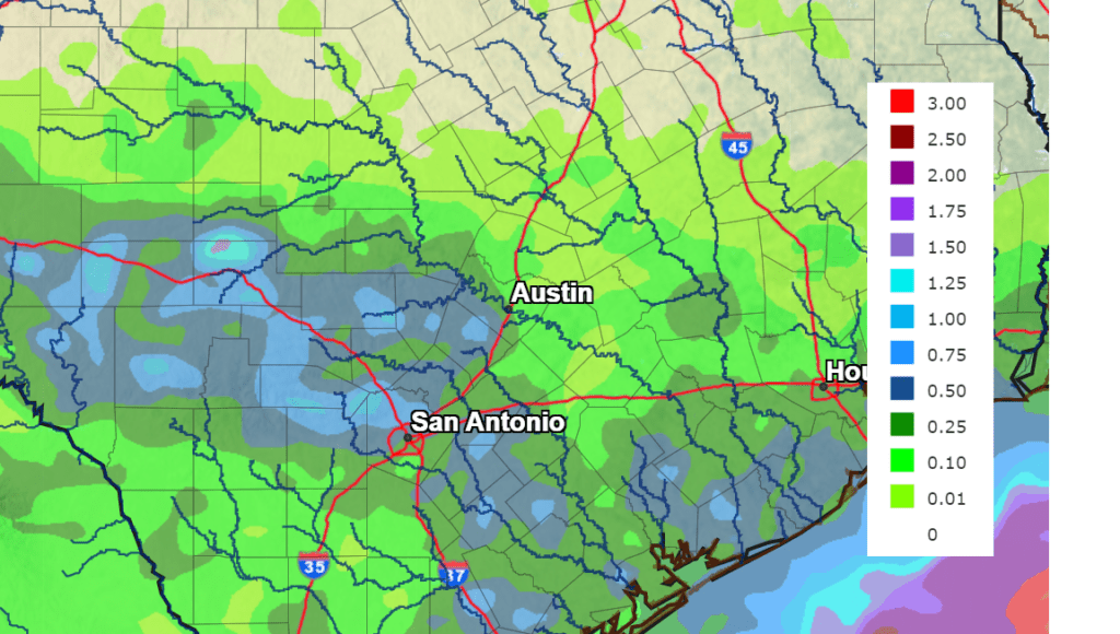
High-resolution forecasts call for scattered to numerous rain showers and scattered thunderstorms to develop across the coastal plains, most of Central Texas and the eastern Hill Country late this afternoon and evening as an area of moisture spreads over the area behind the cold front. Severe storms are not anticipated, but a couple of the thunderstorms could produce small hail and wind gusts of 40-50 mph. Totals from rain this afternoon and evening are forecast to generally be in the range of 0.25-0.50 inches, with isolated totals to near 1 inch possible—especially for locations to the south of Interstate 10 and across the western/southern Hill Country. The probability for rain will generally be around 50-60 percent, with the rain diminishing late Monday evening and toward midnight.
High temperatures Monday are predicted to be in the mid and upper 90s across the region.
On Tuesday, the most favorable area for rain is forecast to be across the coastal plains region and the western Hill Country, where the probability for rain will be around 40-50 percent. Here, most rain amounts are predicted to be in the range of 0.25 to 0.50 inches. For most of the region, however, just a slight chance for afternoon and evening showers and thunderstorms is forecast. Expect a partly cloudy sky with high temperatures in the low and mid-90s.
National Weather Service Rainfall Forecast for the Period 7 pm Monday through 7 pm Tuesday:
The forecast for Wednesday through Friday is somewhat uncertain, since it revolves around the potential development and track of a weak area of low pressure currently located off the coast of southern Louisiana. Most forecast solutions call for the low to track to the southwest, reaching a position off the lower Texas coast Wednesday. Note that National Hurricane Center forecasters are giving this system just a ten percent chance for tropical development through Wednesday. The low is predicted to track north across Southeast and East-Central Texas Wednesday night through Thursday night, exiting off to the north Friday afternoon. Based on this trajectory, the best chance for rain with the low will be for areas underneath the low and to the east, with a much lower probability for rain on the western side of the low. This will translate into a 40-50 percent chance for rain for areas between Matagorda and La Grange, and just a 20 percent chance for rain across the rest of the region (including Austin) Wednesday through Friday. Moisture lingering across the area Saturday will cause a continued slight chance for rain. With the current trajectory of the low, it will lead to a sharp gradient of rain. Rain amounts Wednesday through Saturday are forecast to be in the range of 1-2 inches across the coastal plains region. For the rest of the region, totals are forecast to generally be around a quarter inch.
Keep in mind, should the low take a path further to the west, the chance for rain would likely increase for most of Central Texas and parts of the Hill Country.
Expect a partly cloudy sky Wednesday through Saturday. High temperatures are forecast to be in the mid and upper 90s, with upper 80s to low 90s expected across the coastal plains.
A return to mostly sunny, dry and very hot weather is forecast beginning Sunday as the ridge of high pressure shifts east. Forecasts call for the ridge center to set up over southern Oklahoma and northern Texas through most of next week. This will likely translate into a return of triple-digit temperatures—similar to what we have observed over the past couple of weeks. Daily high temperatures are predicted to be around 100-102 degrees. Looking out further to the week of July 11th, few changes are expected.
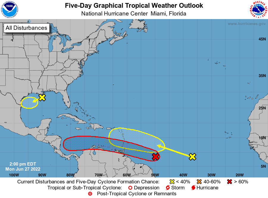
Tropical Weather Outlook
The National Hurricane Center is closely monitoring two strong tropical waves located over the central tropical Atlantic. Neither system poses a threat to the Gulf of Mexico at this time.
A tropical wave number one is located about 700 miles east-southeast of the southern Windward Island, and it is producing a large area of showers and thunderstorms. Environmental conditions appear conducive for development, and a tropical depression or a tropical storm is likely to form during the next day or so before the system reaches the Windward Islands Tuesday night or possibly while moving westward across the southern Caribbean Sea Wednesday through Friday. A NOAA Hurricane Hunter aircraft is currently investigating the system and has found winds to tropical storm force.
Locally heavy rainfall will be possible over the Windward Islands and the northeastern coast of Venezuela Tuesday night and Wednesday.
NHC forecasters are giving this system a 70 percent chance for development over the next 48 hours, and 90 percent chance for tropical development over the next 5 days.
Tropical wave number two is located several hundred miles southwest of the Cabo Verde Islands and is producing disorganized showers and thunderstorms. Environmental conditions could become conducive for gradual development later this week while the system moves west- northwestward at around 15 mph over the central tropical Atlantic.
NHC forecasters are giving this system a zero percent chance for tropical development over the next 48 hours, and just a 20 percent chance for development over the next 5 days.
Disorganized showers and thunderstorms located over the north-central Gulf of Mexico are associated with a trough of low pressure. Development of this system is expected to be slow to occur while it moves west-southwestward at about 10 mph toward the northwestern Gulf of Mexico, It is forecast to approach the coasts of southern Texas and northeastern Mexico during the next few days.
NHC forecasters are giving this system a 10 percent chance for tropical development over the next 48 hours, and a 20 percent chance for tropical development over the next 5 days.
Bob
Social Media