In the wake of last week’s wet and milder than-normal weather, a dry and noticeably warmer pattern has set up across Texas. Monday’s weather maps showed a flat, stable ridge of high pressure in the middle and upper atmosphere stretching from west-to-east across the southern U.S. The ridge is predicted to remain in place throughout the week, causing a very persistent pattern of sunny, dry, hot and humid weather. For the coastal region, extending inland to Fayette, Gonzales and Washington Counties, there will be a slight chance for a few spotty rain showers and isolated thunderstorms each afternoon as the Sea Breeze spreads north from the coast. The chance for rain through Friday will be near 20 percent while rain amounts average around a tenth of an inch or less.
The temperature pattern is forecast to be very persistent this week. Highs each day are forecast to be in the upper 90s across the Hill Country, the mid and upper 90s across Central Texas and the low to mid-90s across the coastal plains. Peak heat index readings today through Wednesday are forecast to reach close to 107 degrees across Central Texas and be between 108 and 110 degrees across the coastal plains region. Because of the unusually high heat index readings forecast, the National Weather Service has posted a Heat Advisory for the middle Texas coast and Southeast Texas through Wednesday.
Breezy conditions look to be in place throughout the week thanks to a moderate pressure gradient between high pressure over the northern Gulf of Mexico and areas of low pressure across the central Plains states. Expect a south breeze at 10-15 mph, with occasional gusts to 20 mph persisting through late week.
A slight chance to a chance for scattered rain showers and thunderstorms will enter the forecast this weekend and early next week as the ridge over Texas weakens and shifts to the west. At the same time, a large trough of low pressure is forecast to sink south from the Great Lakes to the southern Plains and the middle Mississippi Valley region. This trough is expected to pull clouds and moisture north from the Gulf of Mexico. At the same time, showers and storms building across the southern Plains will have the potential to push south into Central Texas. Forecasts call for a 20 percent chance for afternoon showers Saturday, followed 30-40 percent chance for rain and thunderstorms Sunday through next Tuesday.
As of now, rain amounts are not shaping to be all that heavy, with most totals in the range of 0.25-0.5 inches.
High temperatures in the upper 90s Saturday are forecast to lower to the mid-90s Sunday through Tuesday.
Forecasts call for a trend back to mostly sunny and hot weather next Wednesday through Friday as the upper trough lifts off to the northeast. High temperatures are forecast to return to the mid and upper 90s.
We will need to keep a close watch on a developing area of low pressure currently located northeast of Barbados. This system is forecast to track northwest to the eastern Gulf of Mexico by the weekend. (See the tropical weather outlook below for more details).
Tropical Weather Outlook
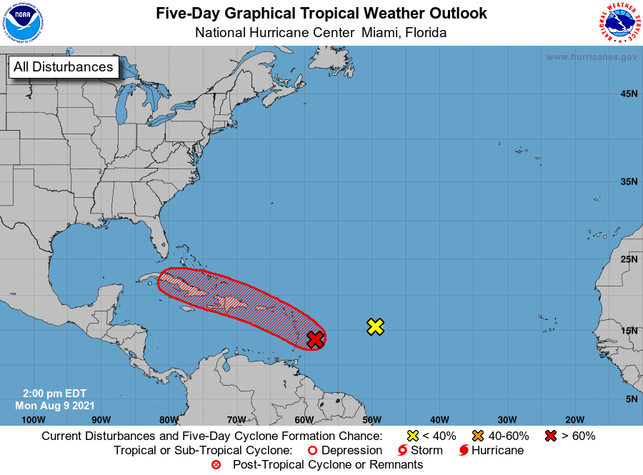
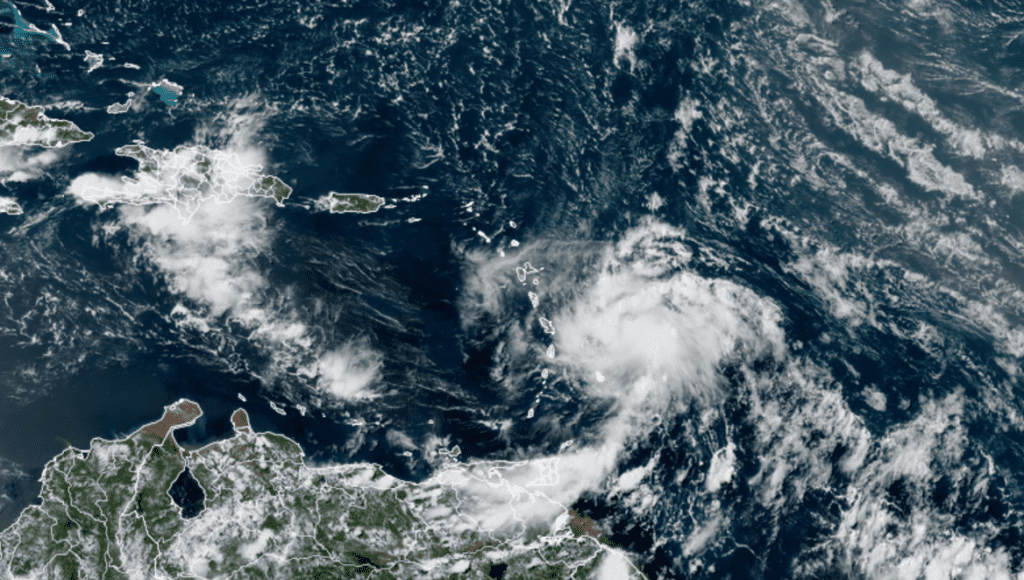
The National Hurricane Center is closely monitoring an area of showers and thunderstorms located in the western tropical Atlantic, about 100 miles east-northeast of Barbados. This area of disturbed weather is associated with an area of low pressure and it continues to show signs of organization. However, recent satellite wind data indicates the system currently lacks a well-defined center. Nevertheless, environmental conditions are expected to remain conducive for additional development, and a tropical depression is likely to form here later today or tonight while the low moves west-northwestward at 10 to 15 mph. The disturbance is forecast to move through portions of the Lesser Antilles tonight, the Virgin Islands and Puerto Rico on Tuesday, and Hispaniola on Wednesday. Tropical storm watches or warnings could be required this afternoon with shorter-than-normal lead times for portions of the Lesser Antilles, the Virgin Islands, and Puerto Rico. In addition, heavy rains and flooding are likely for the Leeward Islands, Virgin Islands, and Puerto Rico. NHC forecasters are giving this system a high chance (an 80 percent chance) for tropical development over the next 48 hours.
It’s too early to have any confidence on where this system will move once in the eastern Gulf of Mexico. Stay tuned for further updates.
NOAA/Colorado State University/RAMMB 08/09/21 1:40 pm CDT
For the past couple of days, forecasters have also been monitoring an area of showers and thunderstorms located several hundred miles east of the Lesser Antilles. Recent satellite images show the showers and thunderstorms associated with this system have diminished as environmental conditions have become unfavorable. Development of this system is no longer expected. NHC forecasters are now giving this system a zero chance for tropical development over the next 5 days.
Elsewhere across the tropical Atlantic, there are no systems in place which pose a threat for tropical development over the next 5 days.
Don’t Miss the Perseid Meteor Shower this Week
With the Moon just days past new and setting around 10 pm, the stage is set for a splendid show of the annual Perseid meteor shower this week. The shower is predicted to reach its peak Wednesday, Thursday and Friday nights, August 11-13. Most observers under good and dark skies may be able to see close to 50 meteors per hour but about half that number from areas that are light-polluted or under cover of wildfire smoke. To maximize your shower enjoyment, find as dark a site as possible.
A modest number of Perseids will be visible starting around 10 pm local time, when the radiant reaches 20° altitude in the northeastern sky. But the later you stay up the more you’ll see: The hours between 2–4:30 a.m. are typically best. That’s when the radiant climbs highest, and the fewest meteors are cut off by the horizon. After midnight, the Earth also rotates into the direction of the meteor stream, which increases the relative velocity at which meteoroids strike the atmosphere, pumping up their brightness, visibility, and number.
Bob
Social Media