Quiet weather is in place on this Wednesday. A cold front moved across the region Tuesday night, causing a few scattered rain showers, but rain amounts generally totaled just a few hundredths of an inch. This cold front is the first in a series of fronts that will move across Texas over the next week, with each one bringing in progressively cooler air.
Wednesday morning’s weather maps showed last night’s cold front had pushed into the Gulf of Mexico, with a bubble of Canadian high pressure spreading south into Texas. Sunny and a little cooler weather will be in place this afternoon, with high temperatures between 65 and 70 degrees. Expect a northerly breeze at 10-15 mph through late afternoon. Winds will turn out of the east and southeast overnight with speeds decreasing to 5-10 mph. Lows Thursday morning will be in the low and mid-40s across the Hill Country and Central Texas regions with low 50s expected across the coastal region.
Thanksgiving Day weather is shaping up to be mostly sunny and quite pleasant. Afternoon temperatures are forecast to warm to 78-80 degrees. Expect a southerly breeze at 5-10 mph.
An active period of weather is forecast to develop Thursday night and continue into early Sunday morning. Forecasts call for a large trough of low pressure to sink into the Desert Southwest Friday, with the trough becoming nearly stationary on Saturday before lifting off to the east northeast Saturday night into Sunday. Out ahead of the trough, considerable moisture is forecast to be drawn inland off the Gulf of Mexico beginning Thursday night. With the atmosphere forecast to become quite moist and moderately unstable, scattered rain showers and isolated thunderstorms look to develop across the coastal plains Thursday evening, with the activity spreading northwest across Central Texas and into the Hill Country after midnight Thursday night.
A cold front is predicted to push south out of Northwest Texas early Friday morning, moving across Central Texas and the middle Texas coast Friday afternoon. A large area of rain showers and scattered thunderstorms are forecast to develop along and behind the cold front. Some of these storms may be strong to possibly severe –mainly for areas east of Interstate 35. The Storm Prediction Center has placed Colorado, Wharton and Matagorda Counties and all of Southeast Texas under a Marginal Risk (1 out of 5 risk) for severe thunderstorms Friday. Large hail and strong winds will be the most likely severe weather threats. The threat for strong to severe storms will decrease Friday evening as cooler air spreads in behind the cold front. Friday’s temperature will be in the low to mid-60s, with low 70s expected towards the coast.
Overrunning clouds and light to moderate rain showers are forecast to occur across the region from Friday night through late Saturday night as the upper trough hangs out to our west. The probability for rain will be near 60-70 percent. The chance for rain will diminish from west to east late Saturday night into Sunday morning as the upper trough exits to the northeast.
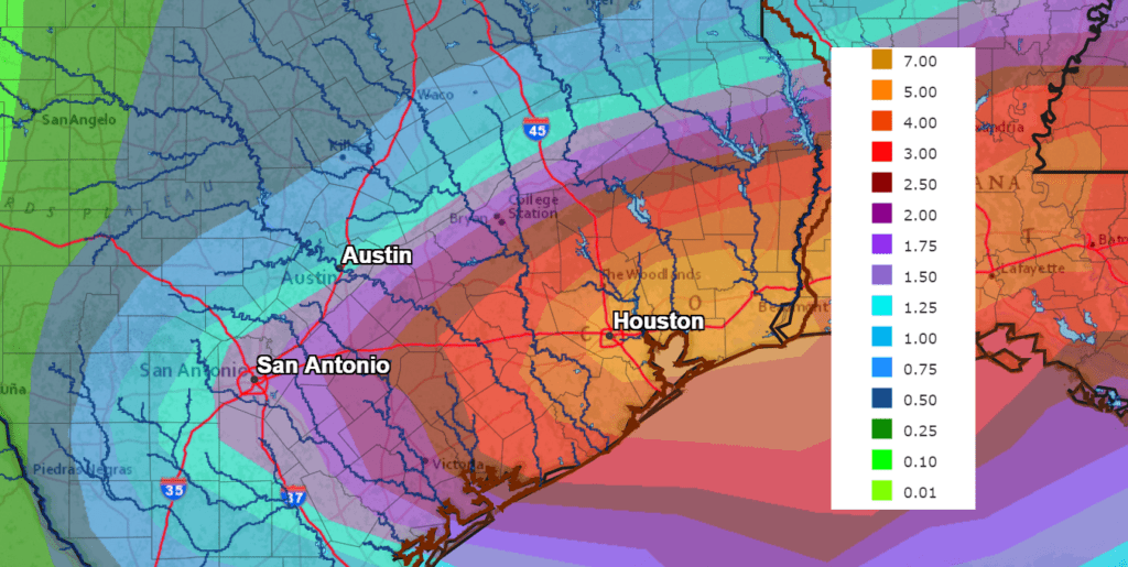
Rain amounts between Thursday night and Sunday morning are forecast to generally total between 0.5 and 1 inch across the Hill Country, between 1 and 2 inches across Central Texas and between 3 and 5 inches for Colorado, Wharton and Matagorda Counties.
NWS Rainfall Forecast for the Period 6 pm Wednesday through 6 pm Monday:
Sunny and dry weather will develop Sunday morning and continue through the middle of next week as a weak ridge of high pressure spreads over Texas out of northern Mexico. A fairly strong Canadian cold front is predicted to sweep south across the area Sunday night, bringing in noticeably colder air for the first half of next week.
Do note this is shaping up to be some of the coldest air we’ve seen so far this autumn and the temperature may reach freezing over the Hill Country and a large part of Central Texas Monday night into Tuesday morning.
- Sunday’s high temperature is forecast to be in the low 60s.
- Lows Monday morning will include the low and mid-30s across the Hill Country, the upper 30s across Central Texas and the lower 40s towards the coast.
- High temperatures Monday will be in the mid and upper 50s.
- Lows Tuesday morning will include the upper 20s across the Hill Country, the low and mid-30s across Central Texas and the mid to upper 30s across the coastal plains.
- High temperatures Tuesday will be in the upper 50s.
- Lows Wednesday morning will be upper 30s to low 40s.
I hope everyone has a safe and happy Thanksgiving holiday and weekend. Try to get outside and enjoy the mild and beautiful weather on Thanksgiving.
Bob
Social Media