Quiet and windy weather is in place across the region as we close out the work week. On Thursday, a powerful area of low pressure tracking across the Midwest helped push a Canadian cold front through Texas. A large dome of Canadian high pressure sinking south behind the front has brought in a mass of cool and very dry air. A very stable atmosphere behind the front will cause a clear sky this afternoon and tonight.
Elevated to near critical fire weather conditions will be in place this afternoon thanks to the combination of strong /gusty winds and very dry air. A strong pressure gradient between the high pressure system over Texas and low pressure near the Great Lakes is expected to cause strong northwesterly winds with speeds of 15-25 mph and occasional gusts to 35 mph through late afternoon. Extreme caution should be used with any type of open flame. Wind speeds will decrease to 5-10 mph this evening and overnight, lowering the elevated fire weather threat.
This afternoon’s temperature is forecast to warm to around 58-62 degrees. A freeze is expected at most locations early Saturday morning. Lows look to be in the mid and upper 20s across the Hill Country and near 30-32 degrees at most other locations.
A sunny to mostly sunny sky is forecast Saturday through Monday. A weak trough of low pressure is predicted to slide southeast across the region Sunday, but due to the lack of moisture, only scattered clouds are expected with the system. High temperatures will be in the low to mid-60s Saturday and Sunday, warming to 68-70 degrees on Monday. Lows Sunday and Monday mornings will be in the mid and upper 30s. Lows Tuesday morning will be in the upper 40s to low 50s.
A big change in the weather is predicted to take place beginning Tuesday. Forecasts call for a large trough of low pressure to sink south along the West Coast to northwestern Mexico early in the week, with the trough eventually tracking east across Texas Wednesday through Friday. Forecast solutions call for considerable moisture to begin spreading north from the Gulf Tuesday in advance of the trough. Scattered rain showers are forecast to develop across the region Tuesday afternoon and Tuesday night. Rain showers and isolated thunderstorms will continue Wednesday through Friday. Forecasts indicate conditions will be favorable for the development of multiple rounds of light to moderate rain. The chance for rain is forecast to diminish next Friday afternoon as the upper trough finally exits to the northeast.
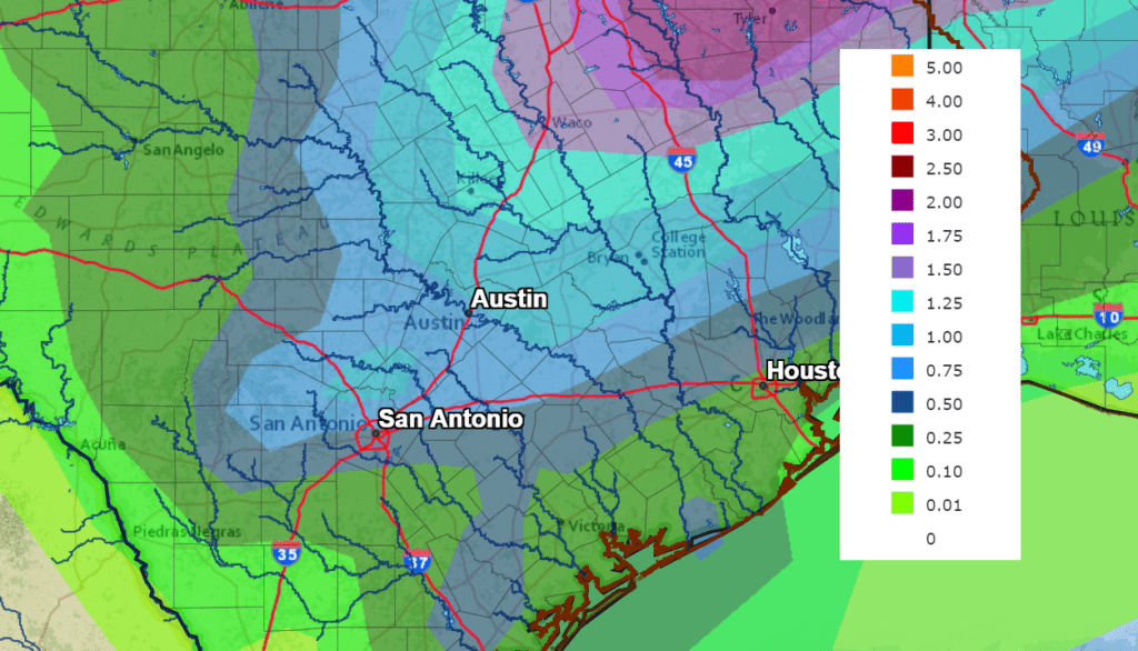
Rainfall forecasts call for the highest totals to occur across the eastern Hill Country and most of Central Texas, with lower totals out west and near the coast. Friday’s forecast data calls for 7-day totals of 1-1.5 inches across the central/eastern Hill Country as well as all of Central Texas. Projected totals could easily go higher as we get closer to the rain event.
NWS Rainfall Forecast for the Period 6 pm Friday through 6 pm next Friday:
The temperature is forecast to remain fairly mild next week, with daily high temperatures in the 60s. Low temperatures will be in the 40s across the Hill Country and in 50s at most other locations.
Sunny and dry weather is forecast next Saturday. Long-range forecasts show the possibility for a few showers developing next Sunday and Monday as a weak trough of low pressure moves over the area. This will be followed by generally dry weather beginning January 26th. No significant change in the temperature is expected the last week of January, with high temperatures in the 50s to low 60s and low temperatures in the 30s and 40s.
Catch Mercury and the ISS this Weekend
The planet Mercury, the solar system’s innermost planet, isn’t hard to see because it’s faint, it’s because this planet is so often lost in the sun’s glare. At present, Mercury is reaching the outer edge of its orbit as seen from Earth, placing Mercury in position for good viewing. Mercury is currently relatively bright. Friday evening, the crescent Moon hangs in the southwest after sunset. It aims its curve lower right almost at Mercury, like a bow ready to shoot an arrow. Mercury will be about two fists at arm’s length from it during twilight. Even farther down in the same direction, you might be able to pick out Jupiter with binoculars. Jupiter is now very nearly on the opposite side of the Sun from us.
Mercury should come into view about 10-15 minutes after sunset in the same location where the sun sets and remain visible for about an hour after sunset. Mercury will remain visible in the western sky till about January 27th. Take advantage of this golden opportunity to view elusive Mercury while the time is at hand!
You can catch a view of the International Space Station each evening through late next week. Note the station’s view will be quite bright and high in the sky Saturday and Sunday evenings. In addition, there will be opportunities to see the station twice in the same evening on Friday and Sunday. Check out NASA’s Spot the Station website for times and directions for your particular area: https://spotthestation.nasa.gov
Have a good weekend.
Bob
Social Media