A dry, summer-like weather pattern continues across Texas as we start off the new week. Over the weekend, parts of the coastal plains and the western Hill Country saw some scattered rain showers, while the rest of the region stayed dry and hot. In fact, the temperature reached 100 degrees at a few spots across the Hill Country and the I-35 corridor on Sunday. Austin-Camp Mabry tied a record high temperature with 101 degrees.
Monday afternoon is shaping up to be sunny, dry and quite hot across all of the state. The combination of a moderate ridge of high pressure in the upper atmosphere across and South Texas and down sloping, southwesterly surface winds of 10-15 mph is expected to cause the development of very hot temperatures. For some locations, today’s high temperature may actually end up being the hottest reading recorded all summer.
- High temperatures are forecast to be near 100-103 degrees across the Hill Country along with Austin and the Central Texas region. Across the coastal plains, high temperatures are forecast to be in the mid and upper 90s.
But some relief is on the way. Monday’s weather maps showed a large trough of low pressure pushing southeast out of the northern Rockies. This trough is pushing the first strong cold front of autumn south across the Rockies and the Plains states. As midday Monday, the front stretched from eastern Nebraska, to near Amarillo, and west to northern New Mexico and northern Arizona. The front will continue pushing southeast this afternoon and tonight and is predicted to reach Northwest Texas about sunrise Tuesday. The front should reach the northern Hill Country around noon, the I-35 corridor mid-afternoon and the I-10 corridor early Tuesday evening. The front will continue tracking southeast Tuesday evening and should push off the middle Texas around or shortly after midnight. Ahead of the cold front, high temperatures Tuesday will range from the upper 80s north, the low and mid-90s across Central Texas and the coastal plains.
With a slightly unstable atmosphere in place ahead of the front, there will be a 20 percent chance for showers and thunderstorms along the front when it moves across the Hill Country. The probability for rain and storms across the Austin/Central Texas area will be near 30 percent. Greater atmospheric instability southeast of Austin will cause a 40-50 percent chance for rain showers and thunderstorms between La Grange and Columbus, and a 60-70 percent chance for rain showers and thunderstorms over the area between Columbus and the coast. The rain should end fairly quickly behind the cold front. Rain amounts will be low—generally under a quarter inch across the Hill Country and Central Texas regions. Totals of a quarter to a half inch will be possible for locations south of Interstate 10.
Northwesterly winds are predicted to increase to a range of 10-20 mph behind the cold front Tuesday afternoon and Tuesday night. Low temperatures Wednesday morning will range from the mid and upper 50s across the Hill Country, to the low 60s across Central Texas, to the upper 60s across the coastal plains.
Sunny, dry and cooler weather will be in place Wednesday through Friday as a dome of Canadian high pressure settles south into Texas behind the cold front. This dome of high pressure will cause more pleasant daytime and nighttime temperatures.
- High temperatures Wednesday will generally be in the mid-80s. Highs will warm to the upper 80s for Thursday and Friday.
- Low temperatures Thursday and Friday mornings will include the low 50s across the Hill Country, the mid-50s across Central Texas and the upper 50s across the coastal plains.
Sunny, dry and slightly warmer weather is forecast for the upcoming weekend. However, with dry air in place, it will still feel somewhat like fall. High temperatures are predicated to be around 90-92 degrees, with upper 80s expected towards the coast. Low temperatures will include the upper 50s across the Hill Country and the low 60s at most other locations.
Look ahead to next week, forecast solutions call for sunny, dry and a little warmer weather throughout the week as the dome of cool air modifies and pushes off to the east. High temperatures are predicted to be in the mid-90s Monday through Wednesday, falling back to the low 90s for Thursday and Friday. Low temperatures will continue in the 60s.
No significant rain is expected over the next two-week period.
Tropical Weather Outlook
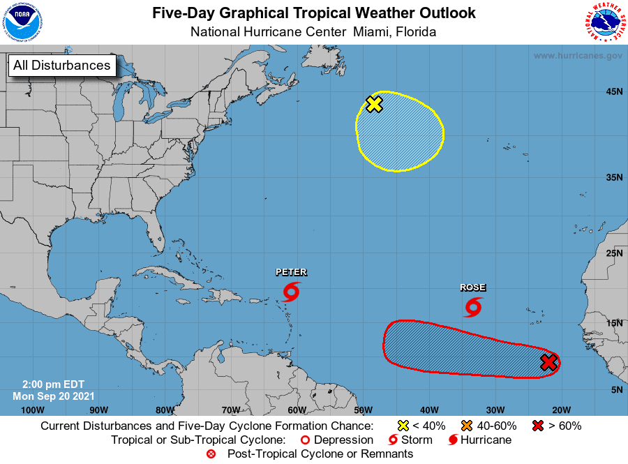
Weather conditions remain quiet across the Gulf of Mexico and the Caribbean Sea. There are no features in place which pose a threat for tropical development here over the next 5 days.
Over the weekend, Tropical Storms Peter and Rose developed across the central tropical Atlantic.
As of late Monday morning, Tropical Storm Peter was located about 175 miles east-northeast of the Leeward Islands. Peter was moving toward the west-northwest near 15 mph and this general motion is expected to continue during the next couple of days, followed by a turn to the northwest with a decrease in forward speed on Wednesday. On the forecast track, the center of Peter will pass north of the northern Leeward Islands and Puerto Rico through Tuesday. Data from an Air Force Reserve Hurricane Hunter aircraft indicate that the maximum sustained remain near 50 mph with higher gusts. Slow weakening is forecast during the next few days and the storm poses no threat to the Gulf region.
Tropical Storm Rose was centered late Monday morning over the east-central tropical Atlantic, about 620 miles west-northwest of the southernmost Cabo Verde Islands. Rose was moving to the northwest near 16 mph, and this general motion with a slower forward speed is expected over the next few days. Satellite wind data indicate that maximum sustained winds remain near 40 mph with higher gusts. Little change in strength is forecast during the next couple of days, and Rose could weaken into a tropical depression by Thursday.
National Hurricane Center forecasters are also closely monitoring a tropical wave located over the far eastern tropical Atlantic, several hundred miles south-southeast of the Cabo Verde Islands. This system is producing an area of showers and thunderstorms that are showing some signs of organization. Upper-level winds are expected to become more conducive for further development by midweek, and a tropical depression is likely to form by Friday while the system moves westward at 10 to 15 mph across the eastern and central tropical Atlantic Ocean. NHC forecasters are giving this system a high chance, a 70 percent chance, for tropical development over the next 5 days.
The Harvest/September Full Moon
The September full moon will occur Monday evening at 6:54 pm CDT. In the Northern Hemisphere, the full moon closest to the autumn equinox is often called the Harvest Moon. Harvest Moon is just a name. In some ways, it’s like any other full moon name. But these autumn full moons do have special characteristics related to the time of moonrise. Nature is particularly cooperative in giving us dusk-till-dawn moonlight, for several evenings in a row, around the time of the Harvest Moon.
On average, the full moon rises around sunset, and rises about 50 minutes later each day. But when a full moon happens close to an autumn equinox, the moon on the following nights rises closer to the time of sunset—generally about 20 to 25 minutes later daily for several days before and after the full Harvest Moon. The difference between 50 minutes and 25 minutes might not seem like much. But it means that, in the nights after a full Harvest Moon, you’ll see the moon ascending in the east relatively soon after sunset.
Astronomical Fall Arrives Wednesday
The autumnal equinox will arrive on Wednesday, September 22, 2021, at 2:21 pm CDT. That’s when the sun will be exactly above Earth’s equator, moving from north to south. At the equinox, days and nights will be approximately 12 hours in length. Everywhere on Earth, except at the North and South Poles, the sun will rise due east and set due west.
Have a good week and enjoy the shift to slightly cooler temperatures.
Bob
Social Media