After a week of warm temperatures, fall-like weather has finally returned to Central and South Texas—at least for a couple of days A strong cold front pushed south across the region Thursday afternoon and Thursday night with gusty winds and noticeably cooler temperatures. While the front came through dry across the Hill Country and Central Texas regions, an area of scattered rain showers developed along and behind the front as it crossed the coastal plains. Totals as of midday have generally been between a tenth and a half of an inch over the area between La Grange and Bay City. It’s interesting to note a small area of moderate to heavy rain developed and persisted over northeastern Wharton and northwestern Fort Bend Counties Thursday evening. As of 2 pm, an LCRA Hydromet gauge located along the San Bernard River near East Bernard, in northeastern Wharton County, has recorded a 24-hour total 2.91 inches.
Thursday’s cold front has pushed into the western Gulf of Mexico. Meanwhile, a large dome of Canadian high pressure is sinking south out of the Plains states, bringing in cooler air. Gusty north winds at 10-20 mph will persist through late Friday afternoon. This afternoon’s weather will range from sunny across the Hill Country to mostly sunny across Central Texas, to a cloudy sky with scattered rain showers across the coastal plains region. An overrunning pattern of clouds and rain has set up behind the cold front across the coastal plains and it is forecast to persist through late afternoon. Additional totals to around a quarter inch will be possible. Today’s high temperature will generally be in the low 70s across the Hill Country and Central Texas regions but only be in low to mid-60s across the coastal plains region.
A partly cloudy to mostly cloudy sky is forecast across the region Friday night into Saturday morning as light east and southeasterly breezes return to the area. Lows Saturday morning will include the low 50s across the Hill Country, the low and mid-50s across Central Texas with mid to upper 50s across the coastal plains.
Widespread low clouds are predicted to blanket the region Saturday morning. These clouds will gradually thin, with the sky becoming partly cloudy Saturday afternoon. Saturday’s temperature should warm to around 80-82 degrees. Southerly winds are forecast to increase to a range of 10-15 mph Saturday afternoon and continue Saturday night. Temperatures will be noticeably warmer Saturday night as warm air spreads north from the Gulf. Lows Sunday morning will include the low and mid-60s across the Hill Country with mid to upper 60s at most other locations.
Sunday’s weather will feature morning clouds, followed by a mostly sunny sky and warm temperatures in the afternoon. Expect a high temperature close to 90 degrees. Lows Monday morning will include the mid-60s across the Hill County and be near 70-72 degrees at most other locations.
A warm and humid pattern is forecast next Monday through Thursday as our region remains under the influence of a moderate wind flow off the Gulf of Mexico. Each day will feature morning clouds, followed by a partly cloudy sky in the afternoon. Forecasts do include a slight chance for a few spotty rain showers and isolated thunderstorms each afternoon for areas along and east of Interstate 35 (including Austin). The probability for rain will only be near 20 percent. Rain amounts, if any, should only total around a tenth of an inch each day. High temperatures are forecast to generally be in the mid-80s while low temperatures will be in the low and mid-60s.
A fairly strong cold front is predicted to sink south across Texas next Friday, bringing cooler temperatures. An even stronger cold front is forecast to sweep through the area next Saturday night into Sunday morning. Forecasts indicate there will be a slight chance for showers along the first cold front Friday, followed by a somewhat better chance for rain and thunderstorms with the second cold front. As of now, rain amounts are predicted to remain below a half inch. High temperatures will be in the low 80s next Friday, cooling to the upper 70s Saturday and the mid-70s next Sunday.
The outlook for the week of October 26th calls for sunny, dry and cooler weather as a large trough of low pressure sets up over the eastern U.S. Daily high temperatures look to be in the upper 60s to low 70s, with low temperatures in the 50s.
Tropical Weather Outlook
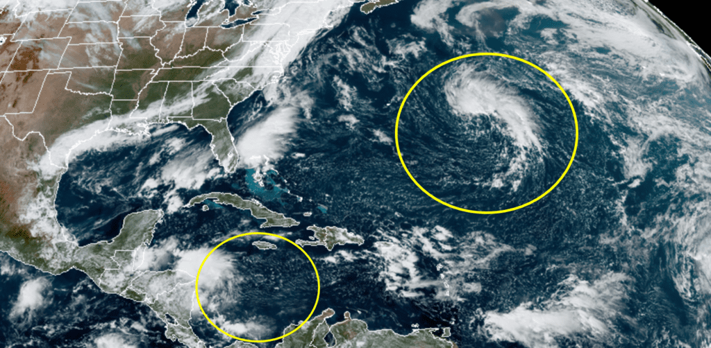
National Hurricane Center forecasters are monitoring a couple of areas of disturbed weather, but neither feature poses a threat to the Gulf of Mexico region.
The first system is a broad non-tropical low pressure system located in the central Atlantic, about 600 miles east-southeast of Bermuda. The low is producing an area of clouds and showers that appears to becoming better organized. Additional development of this system is expected, and a subtropical or tropical depression could form during the next few days while the low meanders over the central Atlantic well to the southeast of Bermuda. NHC forecasters are giving this system a 60 percent chance for development over the next 5 days.
A second area of disturbed weather is forecast to form early next week over the southwestern Caribbean Sea, to the east of Nicaragua and to the north of Panama. Some gradual development of this system will be possible through the middle of next week while it remains nearly stationary over the southwestern Caribbean Sea. NHC forecasters are giving this system a 30 percent chance for development over the next 5 days.
RAMMB-CIRA-Colorado State Universtiry 10/16/2020 12:00 pm CDT
Have a good weekend.
Bob
Social Media