The weather pattern is forecast to become active Thanksgiving Day into Friday as a large trough of low pressure slowly tracks east across North Texas. In advance of the approaching system, weather conditions are forecast to be fairly quiet this afternoon and evening. Expect the sky to remain mostly cloudy sky across the Hill Country and Central Texas regions, but be mostly sunny along the middle Texas coast. There will be a slight chance for a few passing light rain showers, but no significant rain is expected. Temperatures will trend warmer, with readings reaching the mid and upper 50s, and getting close to 70 degrees near the coast.
Changes in the weather are predicted to begin taking place late Wednesday evening and Wednesday night when a moderate southerly flow brings considerable moisture north from the Gulf. Meanwhile, increasing atmospheric lift out ahead of the approaching trough is expected to cause the development of showers and scattered thunderstorms across the region—especially after midnight. The probability for rain will be 50 percent. Lows Thursday morning will generally be in the mid and upper 50s.
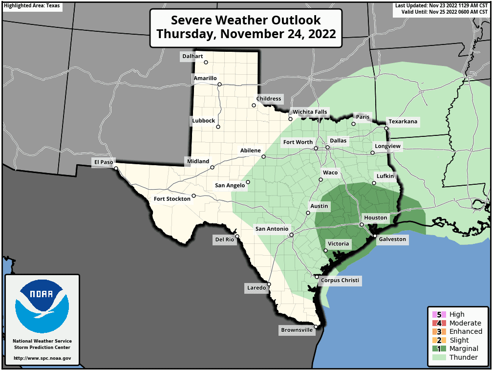
The trend for increasing rain and thunderstorm coverage will continue Thanksgiving Day as a cold front pushes east out of West Texas. Forecasts call for the cold front to move across the Hill Country early to mid-Thursday afternoon, reaching the Austin/Interstate 35 corridor in the late afternoon to early evening. The front is expected to spread across the middle Texas coast sometime around midnight Thursday night. Out ahead of the cold front, showers and scattered thunderstorms are predicted to spread across the area. Some of the storms may be strong to possibly severe—mainly for areas located to the east of Interstate 35. The Storm Prediction Center has placed all Southeast Texas, extending west to Bastrop, Flatonia, and Victoria under a Marginal Risk (a 1 out of 5 risk) for severe thunderstorms through Thursday night. The primary severe weather risk is expected to be damaging straight-line winds. There will be a smaller risk for large hail.
With abundant low-level moisture in place, locally heavy rain will be possible at times—mainly across the eastern Hill Country, all of Central Texas, and the middle Texas coast. Some of the heaviest rain looks to occur along the front as it moves through the area. The rain is forecast to taper off, at least temporarily, once the cold front pushes through.
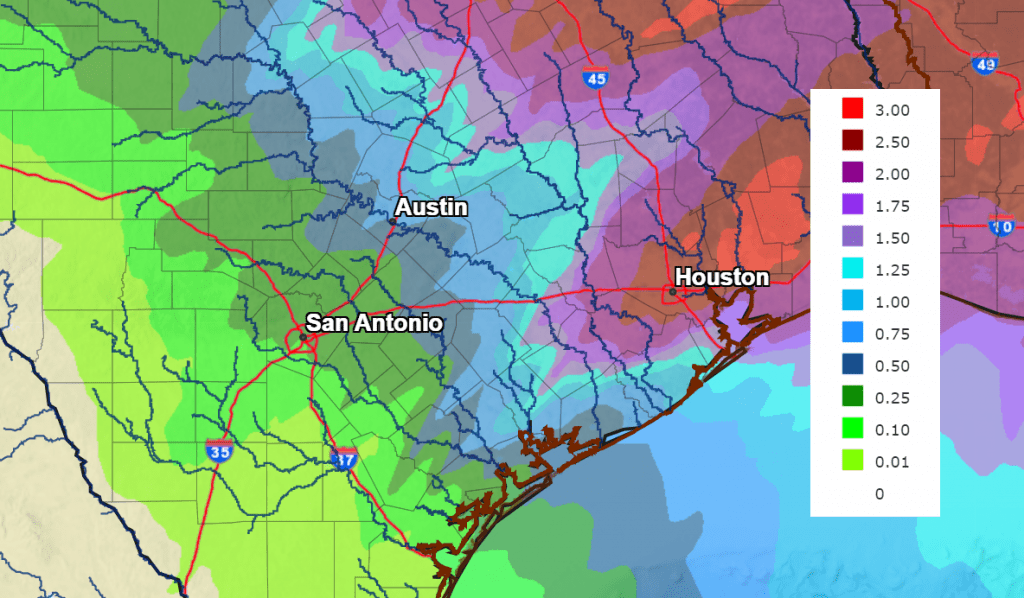
Rain amounts between Wednesday evening and Thursday evening are forecast to generally average between a quarter and a half inch across the central Hill Country, be between 0.5 and 1 inch for the eastern Hill Country and Central Texas regions, and be around 1-1.25 inches across the coastal regions.
Although the cold front will be exiting to the south and east late Thursday, a chance for rain will return to the forecast after midnight Thursday night. Moisture wrapping around the slow-moving upper low over North Texas is predicted to spread across our area, leading to periods of light to occasionally moderate rain showers and even an isolated thunderstorm or two between midnight Thursday night and late Friday afternoon. Rain amounts up to a half inch are forecast. The rain is predicted to taper off from west to east late Friday afternoon into Friday evening as the upper low finally exits to the northeast.
Total rainfall between Wednesday morning and 6 am Saturday is forecast to range from less than a quarter inch across the western Hill Country, to around 1.5 to 2 inches across the middle Texas coast:
NWS Rainfall Forecast for the Period 6 am Wednesday through 6 am Saturday:
Widespread precipitation, breezy north-northwesterly winds, and cloud cover will keep temperatures rather cool on Friday, with highs mostly in the low and mid-50s. Expect northwesterly winds of 10-15 mph, with gusts to 25 mph. Lows Saturday morning will include the mid-30s across the Hill Country, be around 38-40 degrees across Central Texas, and in low 40s near the coast.
Sunny, dry, and mild weather is forecast this weekend and early next week. High temperatures in the mid-60s Saturday, will warm close to 70 degrees Sunday.
The next chance for rain is forecast to occur sometime next Tuesday or Wednesday when a Pacific cols front moves through the area.
Wishing everyone a safe and happy Thanksgiving!
Remember to keep an eye on weather developments throughout Turkey Day.
Bob
Social Media