Much of the area saw sunny and summer-like weather Tuesday. However, scattered rain showers and strong thunderstorms developed across the western/northern Hill Country and also the middle Texas coast. Additional scattered showers and isolated thunderstorms are forecast to develop across the rest of the region Tuesday evening as the atmosphere becomes increasingly moist and unstable. A couple of the storms may even produce locally heavy downpours.
An area of low pressure lifting north across New Mexico is causing the atmosphere across the Hill Country and Central Texas to become quite moist and unstable overnight. High-resolution forecasts call for a large area thunderstorms to develop along the dry line across West Texas late this afternoon and evening. These storms are forecast to slowly spread to the east, reaching the western Hill Country between 9 pm and midnight, the Interstate 35 corridor between about 2 am and 4 am and the coastal plains region early to mid-Wednesday morning.
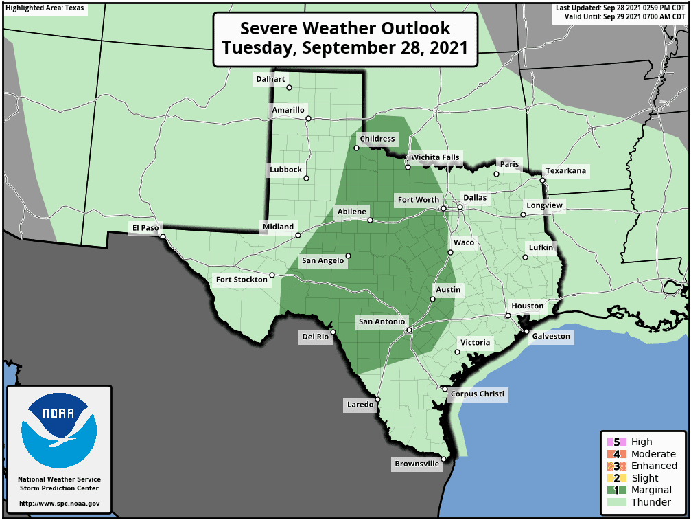
Some of the storms may be strong to severe. The Storm Prediction Center has placed the Hill Country and most of Central Texas, including the Austin metro area, under a Marginal Risk (a 1 out of 5 risk) for severe thunderstorms through 7 am Wednesday. The primary severe weather threat is expected to be damaging downburst winds. There will also be a small risk for large hail.
Rainfall from the storms this afternoon through Wednesday morning are forecast to generally average between 0.5 and 2 inch, with isolated totals to around 3 inches possible.
Wednesday’s weather is shaping up to be mostly cloudy across the region. The area of showers and thunderstorms from overnight is forecast to push toward the coast and weaken. A few afternoon showers cannot be ruled out, but widespread or heavy rain is not expected.
Periods and rain showers and thunderstorms are forecast to occur across our region Thursday through Sunday as another area of low pressure tracks into New Mexico. Small waves of low pressure spreading into Texas are forecast to cause the development of rain showers and thunderstorms. The probability for rain will be near 80 percent Thursday and Friday, near 70 percent Saturday, and near 50 percent Sunday. Daily rain amounts are forecast to average between 0.5 and 1 inch, with isolated heavier totals. Forecasts call for the heaviest rains to fall across the Hill Country.
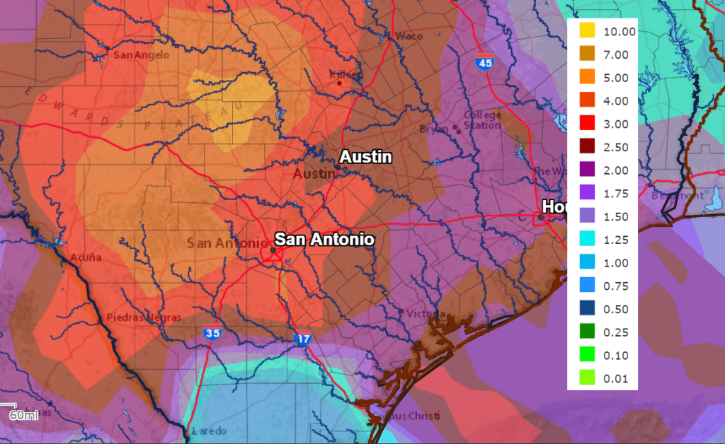
The National Weather Service’s 7-day rainfall forecast calls for cumulative totals of 3-5 inches across the Hill Country, between 2 and 3 inches across the Austin/Central Texas area and 2-2.5 inches across the middle Texas coast.
NWS Rainfall Forecast for the Period 7 pm Tuesday through 7 pm next Tuesday:
Flooding and flash flooding chances could increase by the end of the week if mid-week rain is able to saturate soils.
Bob
Social Media