The weather is currently quiet across the region but conditions will be changing as we move into the weekend, with scattered rain showers and thunderstorms returning to the forecast. In fact, this is shaping up to be the start of a wet, stormy and unsettled weather pattern that is expected to remain in place all of next week and even into next weekend. Although most daily totals are forecast to average less than an inch, accumulated totals by the middle of the week are forecast to reach more than 3 inches, increasing the potential for flash flooding. In addition to the threat for accumulating rain, there will also be the potential for some strong to severe thunderstorms.
This afternoon, the sky is forecast to be partly cloudy across the region. Expect a high temperature close to 80 degrees along with a light southeast wind at 5-10 mph. Scattered thunderstorms are forecast to develop late this afternoon across parts of West Texas and the western Edwards Plateau, but this activity is expected to stay well to the west of our region. Moisture spreading north from the Gulf late this evening will cause our sky to become cloudy. Lows Saturday morning will be in the low and mid-60s.
Expect a cloudy sky across the region Saturday morning. Forecasts call for the development of scattered thunderstorms across the Rio Grande Plains Saturday morning in advance of a wave of low pressure moving out of northern Mexico. Some of these thunderstorms are predicted to spread east to parts of the Hill Country Saturday afternoon, continuing into Saturday night. While severe storms are not expected, these storms may produce small hail and gusty winds. Across Central Texas and the middle Texas coast, increasing atmospheric lift and moisture levels will lead to the development of scattered rain showers and isolated thunderstorms Saturday afternoon and Saturday night. The probability for rain will be near 50 percent. Rain amounts through early Sunday morning look to average between a 0.25 and 0.5 inches. Expect a high temperature near 80-82 degrees.
On Sunday, widespread light to moderate rain showers and scattered thunderstorms are forecast from early morning through mid-afternoon as the wave of low pressure tracks east across Texas. Once again, severe storms are not anticipated, but a couple of strong storms will be possible. The probability for rain will be near 70 percent, decreasing to 30 percent in the late afternoon and Sunday night. Rain amounts Sunday through early Monday morning are forecast to generally average between 0.5 and 0.75 inches, along with some isolated higher totals. High temperatures will be near 80-82 degrees.
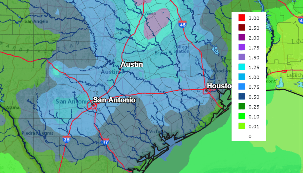
Rain totals Saturday morning through early Monday morning are forecast to generally average between 0.5 and 1 inch.
NWS Rainfall Forecast for the Period 7 am Friday through 7 am Monday:
A very active period of weather is forecast across the region Monday through Wednesday as a large trough of low pressure sinks into the Desert Southwest, then lifts northeast into the southern Plains states. Scattered showers and thunderstorms are forecast to develop across the region Monday afternoon, with more activity continuing Monday night. Forecasts point toward a more widespread coverage of rain showers and thunderstorms developing across the region Tuesday into early Wednesday morning as atmospheric lift from the upper trough spreads over the area. Some strong to severe storms will be possible during this period. Moderate to occasionally heavy rain is forecast. Scattered showers and thunderstorms are predicated to continue Wednesday afternoon into Wednesday night.
Rain amounts from early Tuesday morning through early Thursday morning are forecast to average between 1 and 2 inches, with isolated heavier totals to near 4 inches possible.
Looking out late week and into next weekend, the wet and unsettled pattern looks to continue as additional waves of low pressure are forecast to periodically track across Texas. This will cause periods of rain showers and scattered thunderstorms. Forecasts call for totals to generally average between 0.25 and 0.5 inches each day but could possibly trend higher.
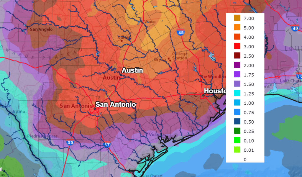
The National Weather Service’s rainfall forecast for the next 7 days calls for widespread totals of 3-4 inches. Isolated totals greater than 6 inches will be possible.
NWS Rainfall Forecast for the Period 7 am Friday through 7 am Next Friday:
As mentioned earlier, scattered showers and thunderstorms are forecast to continue next weekend. Longer-range forecasts call for more scattered rain showers continuing through the first half of the following week (the week of May 24th).
Interestingly, temperatures are predicted to remain fairly mild (by May standards) over the next couple of weeks, with high temperatures staying in the 80s.
Have a good weekend.
Bob
Social Media