The weather pattern became a bit more unsettled over the weekend as the persistent high pressure ridge over Texas slowly weakened and shifted to the west. This allowed for a couple of thunderstorm complexes to push south out of North Texas while at the same time aided in rain and thunderstorm development across the coastal plains. This more unsettled pattern is forecast to remain in place throughout the week, with periods of rain showers and thunderstorms expected between Tuesday and Saturday.
Weather conditions are quiet across the Hill Country and Central Texas region on this Monday. However, at mid-afternoon, a large area of rain and thunderstorms was occurring along the middle and upper Texas coast between Matagorda Bay and Beaumont. This area of rain formed along an outflow boundary which pushed south out of North Texas earlier this morning. The rain and storms are forecast to move into the Gulf by early evening.
For the Hill Country and Central Texas regions, expect a partly to mostly cloudy sky this afternoon and evening. An isolated rain shower or two will be possible for areas along and east of I-35, but the probability for rain will be less than 20 percent. High temperatures will generally be in the mid-90s and be near 90 degrees towards the coast.
Forecasts call for a large complex of rain and thunderstorms to develop along a weak cold front over Northwest Texas this evening. The rain and storms are predicted to spread southeast, reaching the northern Hill Country sometime between midnight and 4 am and the Austin area sometime between 4 am and 7 am Tuesday. The area of rain and storms is forecast to slowly spread southeast across Central Texas and into the coastal plains region Tuesday morning into Tuesday afternoon. Note some of the thunderstorms tonight across the Hill Country and the northern counties of Central Texas may be strong to severe, producing large hail and damaging winds. The Storm Prediction Center has placed the area to the north of a line stretching from Ozona, to Mason to Lampasas under a Slight Risk (2 out of 5 risk) for severe thunderstorms.
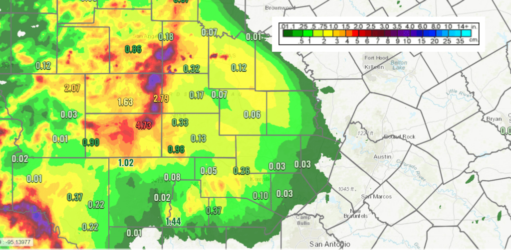
The majority of the rain is forecast to slowly taper off from north to south Tuesday morning through Tuesday afternoon as the complex of storms finally moves over the Gulf of Mexico. However, some additional rain and thunderstorms will be possible across Central Texas and parts of the Hill Country Tuesday afternoon and Tuesday night as the cold front pulls up stationary. Rain amounts Monday night through Tuesday afternoon are forecast to generally average between 0.5 and 1 inch, although a couple of isolated totals of 2-3 inches will be possible. It will be less hot Tuesday in the wake of the rain and thunderstorms, with high temperatures around 88-90 degrees.
Forecasts call for the cold front to briefly sink south to a position near Interstate 10 Wednesday before moving back north as a warm front on Thursday.
Periods of rain showers and thunderstorms are forecast to continue across the region Wednesday through Friday as small waves of low pressure dip south into Texas out of the southern Plains. A very moist air mass looks to continue. The probability for rain each day will be near 40-50 percent. Rain amounts are forecast to average around a half inch per day, with isolated totals of 1-2 inches possible. High temperatures Wednesday through Friday are forecast to be near 90-92 degrees,
The wet and unsettled pattern is predicted to come to an end late Friday into Saturday as a ridge of high pressure begins to spread over Texas out of the southeastern U.S.
According to the National Weather Service, total rainfall between Monday afternoon and Saturday morning is forecast to generally average close to 2-2.5 inches. Some isolated heavier totals will certainly be possible.
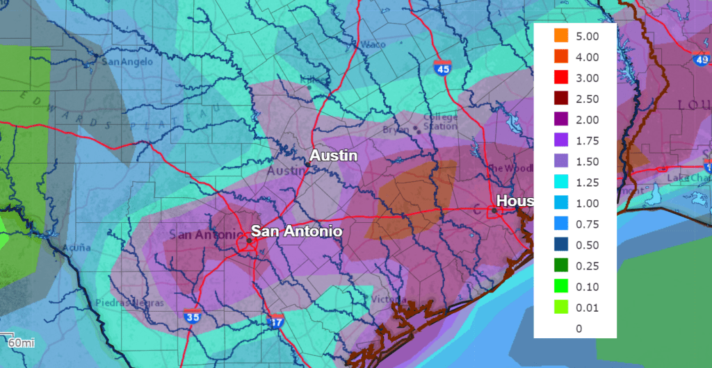
NWS Rainfall Forecast for the Period 7 pm Monday through 7 pm Saturday
Mostly sunny and dry weather is forecast this weekend and early next week. High temperatures are predicted to be back in the middle 90s. A chance for rain showers and thunderstorms looks to return to the forecast the middle and latter parts of next week as a series of low pressure troughs track north out of Mexico. High temperatures next week look to stay mostly in the mid-90s.
Tropical Weather Outlook
The non-tropical low pressure system that the National Hurricane Center has been following for the past couple of days off of the
U.S. east coast developed enough organized convection near the center late Monday to be classified as subtropical depression. The subtropical status is due to the low-level circulation center being co-located beneath an upper-level cold low as seen in water vapor imagery. As of 4 pm CDT, the center of the Subtropical Depression Four was centered about 310 miles southeast of Nantucket, Massachusetts. The system is moving toward the east-northeast near 9 mph and this motion is forecast to continue through tonight. A motion toward the northeast is expected on Tuesday and Wednesday. Maximum sustained winds are near 35 mph with higher gusts. Some slight strengthening is possible tonight and early Tuesday, and the subtropical depression could briefly become a subtropical storm. Slow weakening is expected to begin by Tuesday afternoon or evening.
RAMMB-CIRA 06/22/20 10:40 am CDT
Elsewhere, weather conditions are quiet and there are no systems which pose a threat for tropical development over the next 5 days.
Sharan Dust Update
A large cloud of Saharan dust is still on track to spread into Texas beginning Wednesday, continuing through the end of the week and into the weekend. Reports from several Caribbean islands over the weekend indicated reduced visibility under a hazy sky. It’s a little early to know how the dust will affect Central Texas as our region is expected to have considerable clouds and scattered rain late this week. The dust cloud is quite visible on a Monday morning visible satellite image:
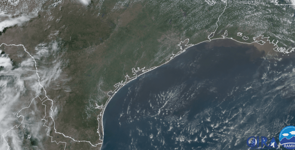
RAMMB-CIRA 06/22/20 10:40 am CDT
Bob
Social Media