A strong, early season arctic air mass is currently pushing south across Texas. As of 2 pm, the leading edge of the cold air stretched from just north of Bryan to Bastrop to near Del Rio. Early afternoon temperatures included the upper-30s across the northern Hill Country with low and mid-40s in place across much of the rest of the Hill Country. Temperatures have dropped into the mid-50s across the Austin area but were in the low and mid-80s in the area between Smithville and Matagorda. Forecasts call for the cold front to continue moving to the south/southeast this afternoon and evening, reaching the La Grange/Columbus area in the late afternoon to early evening. The front is predicted push off the coast after midnight Monday night. Temperatures look to remain steady across the Hill Country this afternoon. Across Central Texas, temperatures should fall through the 60s and into the 50s. Warm temperatures will hold in place across the coastal plains region through this evening.
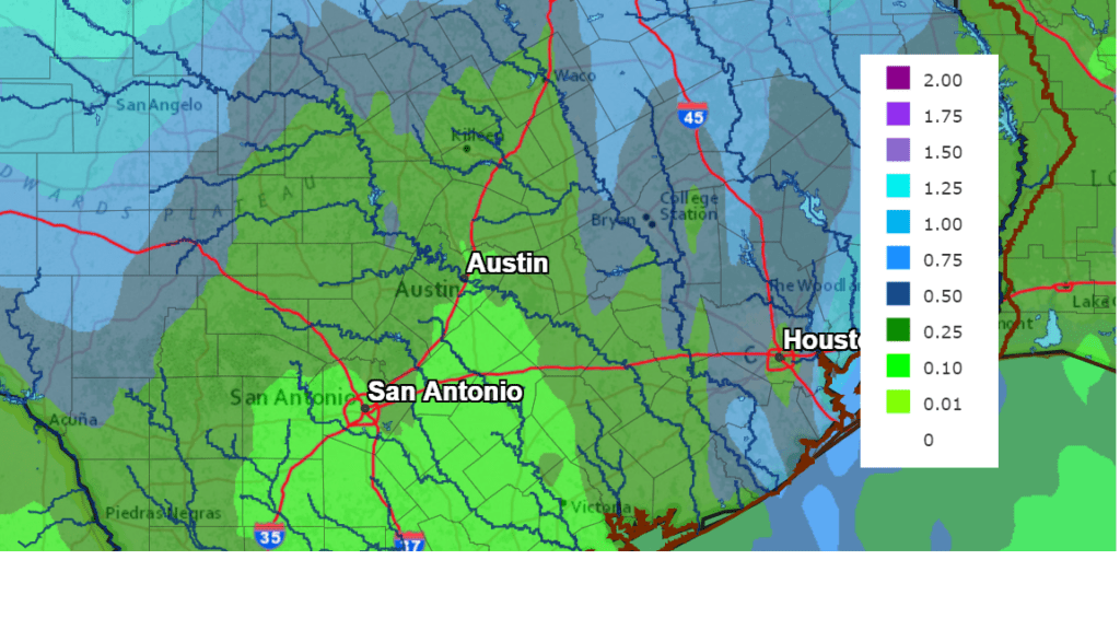
This afternoon, a trough of low pressure in the middle atmosphere located over Utah is sinking south into Arizona. A southwesterly flow ahead of the trough is helping to cause scattered light rain showers and drizzle across the region. Additional light showers are forecast to continue overnight. A somewhat better chance for occasional rain showers is forecast Tuesday through Wednesday afternoon as the upper trough tracks from southern Arizona to Northwest Texas and the southern Plains states. The rain is forecast to taper off morning as the upper trough lifts off to the northeast. Forecasts call for temperatures to remain above freezing across the Hill Country through Wednesday, keeping all of the precipitation liquid. Totals through Wednesday afternoon are forecast to generally be between 0.25 and 0.5 inches for most of the region.
NWS Rainfall Forecast for the Period 7 pm Monday through 7 pm Thursday:
Chilly temperatures will be in place across the Hill Country and Central Texas regions Tuesday and Wednesday.
- Lows Tuesday morning will include the mid and upper 30s across the western and northern Hill Country and be around 40 degrees across the rest of the Hill Country. Low to mid-40s are forecast for Central Texas with mid and upper 50s for the coastal plains.
- High temperatures Tuesday will range from the mid and upper 40s across the Hill Country to the upper 40s to low 50s across Central Texas to the mid and upper 60s near the coast.
- Lows Wednesday night will include the upper 30s to mid-40s across the Hill Country, the upper 40s across Central Texas and upper 50s to low 60s across the coastal plains.
- High temperatures Wednesday will be in the upper 50s to low 60s across the Hill Country and Central Texas regions and be close to 70 degrees across the coastal plains.
- Lows Thursday morning will range from the low 40s across the Hill Country to the mid-40s across Central Texas to near 50 degrees towards the coast.
- High temperatures Thursday will generally be in the mid-60s, with lower 70s expected towards the coast.
As the upper trough exits to the northeast, it will help push another cold front across the area late Wednesday, bringing dry air and reinforcing the cool temperatures already in place. Sunny and dry weather is forecast Thursday, continuing through the weekend.
High temperature are predicted to be in the mid-60s Friday, warming to the low 70s Saturday and Sunday. Low temperatures will be in the low and mid-40s across the Hill Country and Central Texas regions and be close to 50 degrees across the coastal plains.
The outlook for next week calls for sunny, dry and mild weather conditions as a stable ridge of high pressure sets up over Texas and the south central US. High temperatures are predicted to be in the 70s, with low temperatures generally in the upper 40s to low 50s. Forecasts do not show another chance for rain through November 9th.
Tropical Weather Outlook
Hurricane Zeta is strengthening and churning across the western Caribbean Sea. As of 210 pm CDT, the center of Hurricane Zeta was located by an Air Force Reserve Hurricane Hunter aircraft about 105 miles southeast of Cozumel, Mexico. Zeta was moving toward the northwest near 10 mph. A northwestward motion with some increase in forward speed is expected over the next day or so, followed by a turn toward the north Tuesday night. A faster northward to north-northeastward motion is forecast on Wednesday. On the forecast track, the center of Zeta will move near or over the northern Yucatan Peninsula later today or tonight, move over the southern Gulf of Mexico on Tuesday, and approach the northern Gulf Coast on Wednesday.
Maximum sustained winds have increased to 80 mph with higher gusts. Strengthening is forecast, and Zeta is expected to become a hurricane later today. Some weakening is likely while Zeta moves over the Yucatan Peninsula tonight and early Tuesday. Zeta is forecast to strengthen again while it moves over the southern Gulf of Mexico later on Tuesday.
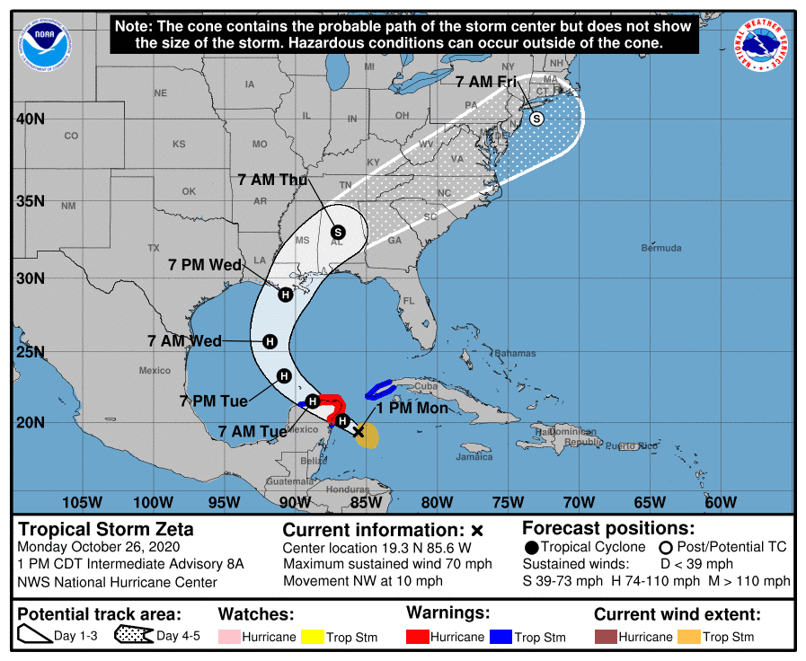
Zeta poses little to no threat to the Texas coast.
Time Change Weekend
A reminder this weekend will not only be Halloween and a full moon, it will also be time change weekend as we move back to Central Standard Time. The time change will occur Sunday morning, November 1st, at 2:00 am. At that time we “fall back”, or turn our clocks back one hour. For many of us, it means an extra hour of sleep. Don’t forget to check your smoke alarms at the same time.
Have a good week.
Bob
Social Media