Sunny and quiet weather is currently in place across Central and South Texas. Dry air has allowed for some pleasant, cool mornings the past couple of days, but warmer and more humid air is about to make a quick return. In the meantime, this afternoon’s weather will be mostly sunny, warm and breezy with high temperatures in the mid and upper 80s. Expect a southerly breeze 10-15 mph.
Today’s southerly breezes will begin pulling moisture north from the Gulf of Mexico. In fact, a widespread area of low clouds is predicted to develop across the region shortly after midnight tonight. Low temperatures Saturday morning will generally be in the low and mid-60s. Wind speeds of 10-15 mph are forecast overnight.
For Saturday, widespread clouds are expected to hold through the morning hours Mostly sunny, breezy and warm weather will develop by the afternoon. High temperatures look to be around 88-90 degrees. Southerly breezes will be increasing to 10-20 mph, with occasional gusts to 30 mph.
There will be a slight chance for a few scattered rain showers and isolated thunderstorms to develop across the Hill Country and Central Texas regions after midnight Saturday night, continuing through Sunday morning when a weak wave of low pressure tracks east out of northern Mexico. The probability for rain at any given location will only be 20 percent and conditions don’t appear all that favorable for severe storms. Rain amounts, if any, should total less than a tenth of an inch. The chance for rain should diminish by early Sunday afternoon.
For Sunday afternoon, expect the sky to become partly cloudy as the wave of low pressure exits to the east. It will be a warm day, with high temperatures close to or just above 90 degrees. Expect more breezy south winds with gusts to 25 mph.
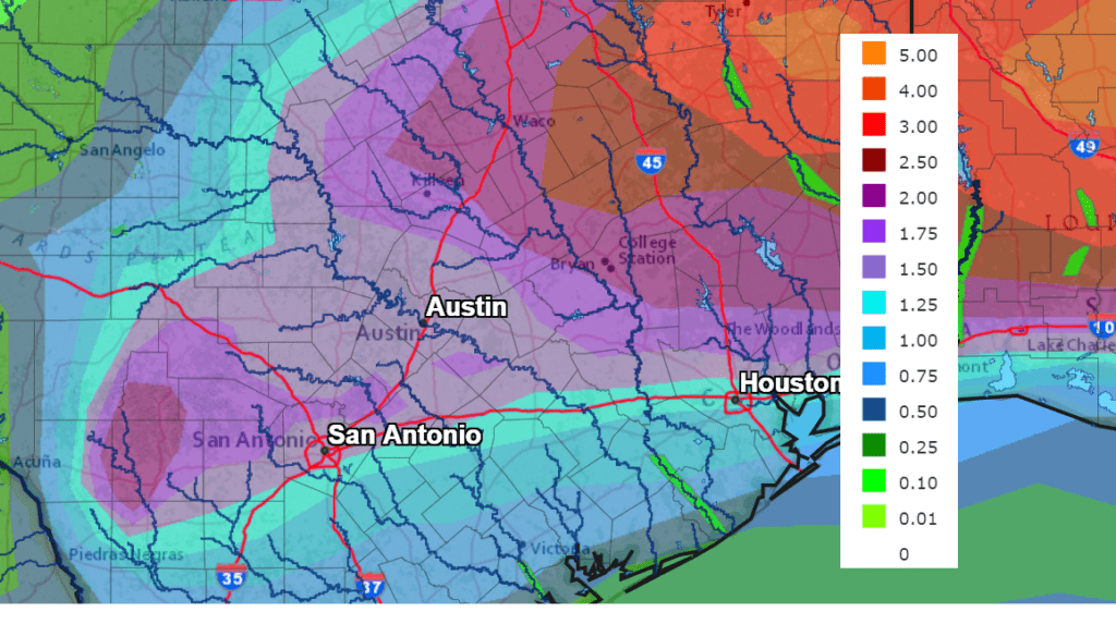
Big changes in the weather pattern are forecast to take shape early next week that looks to bring our region multiple rounds of showers and storms. A Canadian cold front is forecast to sink south through the area on Monday, pulling up stationary somewhere just south of Interstate 10 Monday night. Meanwhile, forecasts are also calling for several waves of low pressure to begin tracking east out of northern Mexico on Monday. This particular setup is expected to bring rounds of showers and scattered thunderstorms to the region starting Monday afternoon, with the activity continuing through Wednesday night. Moderate to occasionally heavy rain is forecast with some of these passing low pressure waves. As of now, it’s just too early to get a good handle on which area or areas will be favored to see the heaviest rain. National Weather Service 7-day rainfall forecasts call for widespread totals of between 1 and 1.5 inches across much of the Hill Country and Central Texas, with slightly lower totals expected across the middle Texas coast. Isolated heavier totals will be possible. In addition, some of the thunderstorms next week may be strong or possibly severe.
NWS Rainfall Forecast for the Period 7 pm Friday through 7 pm next Friday:
Monday’s cold front is expected to bring cooler temperatures beginning Monday night. High temperatures Tuesday and Wednesday will be in the upper 70s to low 80s. Low temperatures Wednesday and Thursday mornings will be in the upper 50s to low 60s.
Forecasts call for sunny and dry weather to develop next Thursday, continuing through next weekend as a stable ridge of high pressure spreads over Texas out of the Desert Southwest. High temperatures are forecast to be in the upper 70s to low 80s Thursday and Friday, warming to the mid-80s next weekend. Low temperatures will be in the 60s.
Looking out into the week of May 17th, long-range forecasts are calling for our weather pattern to trend unsettled as a series of low pressure troughs begin moving into Texas out of the Desert Southwest. Periods of showers and thunderstorms are forecast throughout the week. High temperatures are predicted to be mainly in the mid and upper 80s.
Welcome Back Venus!
After spending the past month in the glare of the sun, the planet Venus has returned the evening sky. Look for it low in the west-northwest sky, in the afterglow of sunset. The planet Mercury will also be visible, coming into view some 9° above Venus. Mercury is currently fairly bright, but will be trending a little dimmer next week.
Have a good weekend.
Bob
Social Media