Following a sunny and warm weekend, weather conditions will begin to change this afternoon and tonight as low-level moisture begins returning in earnest off the Gulf of Mexico. The focus for rain and storms this week will be a trough of low pressure in the upper atmosphere that is currently dropping south along the West Coast. The trough is forecast to move across the Desert Southwest on Tuesday, the southern Rockies Tuesday night and Wednesday, West-Central Texas Wednesday night, and eventually through Central Texas Thursday and Thursday night. This system is predicted to bring an increasing chance for rain to our region beginning Tuesday afternoon, with the overall best chance for rain occurring Wednesday night into Thursday. The chance for rain looks to diminish on Friday.
Late morning satellite images showed widespread middle and high-level clouds spreading across Texas out of northern Mexico. These clouds will cause a mostly sunny to partly cloudy sky across the region this afternoon. Conditions will be breezy and warm, with temperatures topping out in the mid and upper 80s. Expect a southerly breeze at 10-20 mph, with occasional gusts to 30 mph.
Low clouds will increase late this evening and the sky will become cloudy by about midnight. Breezy and warm conditions are forecast overnight. Lows Tuesday morning will be in the mid and upper 60s. South winds at 10-20 mph will continue overnight.
A noticeable change in the weather is predicted for Tuesday, continuing into Tuesday night as weak waves of low pressure begin moving over Texas in advance of the large upper trough located over the Desert Southwest. A cloudy sky is forecast. There will be a slight chance to a chance for scattered light rain showers by afternoon, continuing through Tuesday night. A few scattered thunderstorms will be possible across the western and northern Hill Country Tuesday night. The probability for rain Tuesday and Tuesday night will be near 30 percent. High temperatures will be in the low and mid-80s. Lows Wednesday morning will be near 70-72 degrees. Breezy conditions will continue, with speeds of 10-20 mph.
Forecasts call for the development of showers and thunderstorms along the dry line, generally over the Concho Valley and the western Hill Country Wednesday afternoon. The activity is predicted to slowly spread east across the Hill Country Wednesday evening and across the Hill Country and the Interstate 35 corridor Wednesday evening and Wednesday night. Note some of these thunderstorms may be strong to severe. The Storm Prediction Center has already placed the Hill Country and the Interstate 35 corridor under a Marginal Risk (a 1 out of 5 risk) for severe thunderstorms. Primary severe weather threats will be large hail and damaging winds. High temperatures Wednesday will be in the mid and upper 80s.
The area of rain and storms that develops Wednesday evening and Wednesday night is forecast to be slow-moving and will have the potential to produce significant totals of rain over some parts of the Hill Country and the I-35 corridor into Thursday morning. Unfortunately, these areas of heavy rain can’t be pinpointed this far out. In general, totals of 1-2 inches are forecast across this area, but isolated total of 3 to 5 inches will be possible in locations where the storms set up and train.
On Thursday, the focus for rain and storms is predicted to exit the Hill Country and shift more towards Central Texas and the middle Texas coast. The threat for severe storms and heavy rain doesn’t appear to be as great as was forecast for the Hill Country and the I-35 corridor. The probability for rain will be near 50 percent. Meanwhile, a 30-40 percent chance for scattered showers and isolated thunderstorms will continue across the Hill Country and the I-35 corridor. Temperatures will trend cooler behind a Pacific cold front Thursday. High temperatures will generally be in the mid to upper 70s, with middle 80s hanging on across the coastal area.
A slight chance for rain showers is forecast across the region Thursday night into Friday morning in a weak overrunning pattern. Clouds will decrease with the sky becoming mostly sunny Friday afternoon. Expect a high temperature in the upper 70s.
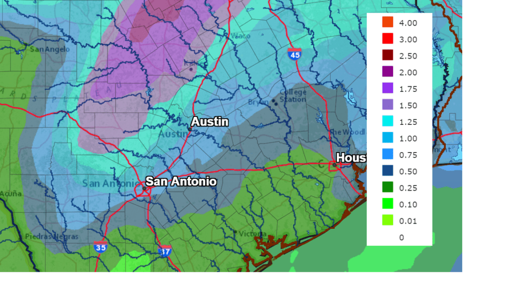
Rainfall forecasts for this week call for the highest totals to occur across the Hill Country, with the lowest totals expected across the coastal plains. In general, amounts of 1 to 2 inches are forecast across the Hill Country and the I-35 corridor, with totals of 0.5 to 1 inch across much of Central Texas. For areas south of Interstate 10, totals of 0.25 to 0.5 inches are forecast.
NWS Rainfall Forecast for the Period 7 am Monday through 7 am Saturday:
Sunny and dry weather is forecast this coming weekend as the atmosphere driest out in the wake of the upper trough. Expect high temperatures in the low 80s Saturday and into the mid to upper 80s on Sunday. Lows will be in the upper 50s to low 60s.
Looking out into next week, forecasts are calling for a sunny, dry and warm pattern as a ridge of high pressure spreads over the state. High temperatures are forecast to be close to 90 degrees, with low temperatures in the upper 60s. Long-range forecasts indicate we could see our next chance for rain developing sometime over the weekend of May 8th.
Full Pink Moon Monday Night
Venture outside tonight, April 26th, to catch a glimpse of April’s full Pink Moon. This full Moon will be the first of two supermoons this year. It will be visible after sunset and reach peak illumination at 10:33 pm CDT. Just how big and how bright, exactly? On average, supermoons are about 7% bigger and about 15% brighter than a typical full Moon. However, unless you were to see a regular full Moon and a supermoon side by side in the sky, the difference is very, very difficult to notice!
Although we wish this name had to do with the color of the Moon, the reality is not quite as mystical or awe-inspiring. In truth, April’s full Moon often corresponded with the early springtime blooms of a certain wildflower native to eastern North America called creeping phlox or moss phlox—which also went by the name “moss pink.”
Have a good week.
Bob
Social Media