Wednesday afternoon, the Storm Prediction Center issued a Severe Thunderstorm Watch for the middle and upper Texas coast through 8 pm. The watch includes Wharton and Matagorda counties. Scattered thunderstorms are predicted to develop along a stalled boundary across the coastal plains region this afternoon and evening. The atmosphere has become quite moist and unstable this afternoon. Although the watch only extends inland two counties, strong to severe thunderstorms will also be possible a little further inland across parts of Colorado and Fayette counties. Large hail and damaging winds will be the primary severe weather threats. Locally heavy rain will be possible with a few of the storms. Totals are forecast to average around a half inch, with isolated totals of 1-2 inches possible.
For the Hill Country and Central Texas regions, there will be a 20-30 percent chance for scattered showers and isolated thunderstorms this afternoon and overnight. Severe storms are not anticipated. For locations do happen to see rain, totals should average less than a quarter inch.
Morning forecast solutions call for rain showers and scattered thunderstorms to increase in areal coverage across the Hill Country Thursday morning as a wave of low pressure pushes east across the southern Plains, creating a moderately unstable atmosphere. Showers and thunderstorms are forecast to spread east to Central Texas late morning and afternoon. Showers and storms are also forecast to increase across the coastal plains region in the afternoon. The atmosphere is predicted to again be moderately unstable and there is low risk some of the storms may become severe. The Storm Prediction Center has placed the entire region under Marginal Risk (1 our of 5 risk) for severe thunderstorms through Thursday night. Totals Thursday are forecast to average around a half inch, with isolated totals to near an inch. The probability for rain will be 50 percent.
Forecasts call for another good chance for rain Friday into Friday night when a second wave of low pressure tracks east out of New Mexico, forcing a cold front south across the state. As of now, widespread severe storms are not expected. But periods of rain showers and scattered storms can be expected, with the probability for rain near 60-70 percent. Total of a quarter to a half inch are forecast.
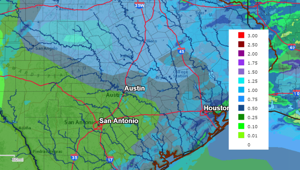
NWS Rainfall Forecast for the Period 7 pm Wednesday through 7 pm Monday:
The chance for rain is predicted to taper off from west to east Saturday morning as drier and cooler air spreads in behind the cold front. A mostly cloudy sky is forecast Saturday, followed by a partly cloudy sky on Sunday.
Temperatures will be noticeably cooler Saturday and Sunday, with high temperatures both days in the mid-60s. Lows Sunday and Monday mornings will include the low 40s across the Hill Country, the mid and upper 40s across Central Texas and around 50-52 degrees across the coastal plains. Sunny and mild weather is expected the first half of next week, with high temperatures staying in the 70s.
Bob
Social Media