Forecasts indicate there will be another threat for strong to severe thunderstorms across parts of the Hill Country and Central Texas, including the Austin area, from late this afternoon through early Thursday morning.
Wednesday’s weather maps showed the cold front responsible Tuesday’s pleasant weather is quickly returning north from the coast as a warm front. As a result, warmer and noticeably more humid air is beginning to spread across the region. Meanwhile, a large trough of low pressure is currently located over southern New Mexico. This system is predicted to track across northwestern and northern Texas tonight into Thursday morning, causing the atmosphere over our region to become increasingly unstable. Abundant moisture, atmospheric lift and favorable winds in the upper atmosphere late today into tonight will make conditions favorable for the development of strong to severe storms.
This afternoon, expect a partly to mostly cloudy sky across the area. Scattered rain showers and even a few isolated thunderstorms are forecast to develop in the moist and somewhat unstable atmosphere. The probability for rain will be around 30 to 40 percent. The threat for severe storms through the late afternoon appears low for most of the region. However, storms across the area between Abilene, San Saba and Menard could become strong to severe. Expect a high temperature this afternoon near 78-80 degrees.
Forecasters will be keeping a close watch on possible thunderstorm development late this afternoon out west across the Concho Valley and the Edwards Plateau, where thunderstorms may develop along the dry line and track to the east. These storms will have the potential to become severe and track east over parts of the Hill Country and even as far as the Interstate 35 corridor through the late evening. Large hail and damaging winds will be possible with these storms.
However, the most favorable period for strong to severe thunderstorms is forecast to occur after midnight and toward daybreak Thursday. Forecasts call for an area of thunderstorms to develop along a Pacific cold front over western Texas this evening, with the storm activity spreading to the east overnight. The area of rain and storms is forecast to spread across the Hill Country shortly after midnight, reaching the Interstate corridor around 3-5 am. The rain and storms are predicted to push southeast across Central Texas and the coastal plains region between 5 am and 10 am Thursday.
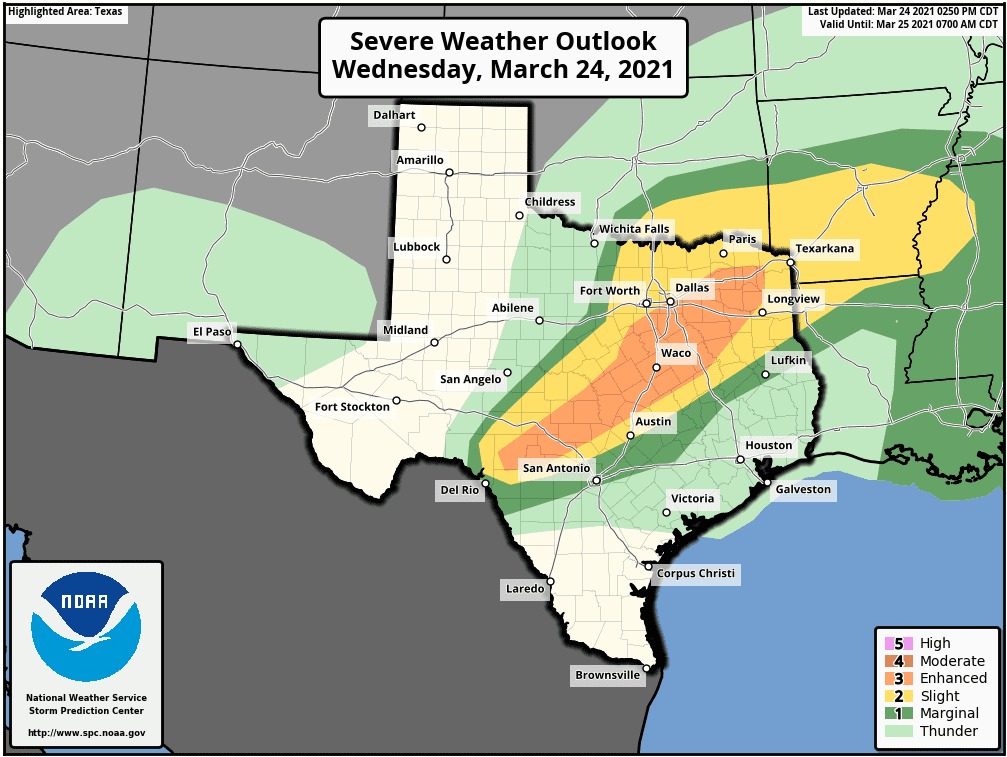
Atmospheric conditions are looking quite favorable for many of the thunderstorms to become severe overnight. The Storm Prediction Center has placed most of the Hill Country and the northern counties of Central Texas under an Enhanced Risk (3 out of 5 risk) for severe thunderstorms overnight into Thursday morning. The area generally runs from Rocksprings and Leakey, to Fredericksburg and Llano/Burnet, to just north of Austin, to Temple, Waco and Tyler. Much of the rest of the Hill Country and the Austin area have been placed under a Slight Risk (2 out of 5 risk) for severe thunderstorms. A Marginal Risk (1 out of 5 risk) is noted for the area between Austin and La Grange. The threat for severe storms for the area south of Interstate 10 appears low.
Severe weather threats will include tornadoes, large hail, damaging thunderstorm winds and dangerous lightning.
Rainfall from showers and thunderstorms this afternoon through Thursday morning are forecast to generally average between a quarter and a half inch. Isolated totals to near 1 inch will be possible—mainly for the western and northern Hill Country.
The rain and thunderstorms should exit the coastal area late Thursday morning. Thursday afternoon and Friday’s weather is shaping up to be sunny. Expect a high temperature in the mid-70s Thursday, warming to the low 80s Friday.
I urge everyone to keep up with the latest weather developments this afternoon through early Thursday morning. Pay close attention to local media and NOAA All-Hazards radio for the latest information and potential watches and warnings. Make sure you have at least two methods to receive NWS information.
Bob
Social Media