Weather conditions were quiet and warm across the region Tuesday afternoon. However, this will change late Tuesday night when an area of rain and thunderstorms is predicted to develop along and behind an advancing cold front. High-resolution forecasts call for a broken line of thunderstorms to develop along the cold front when it moves into West Texas this evening, from around Childress, to just west of Del Rio. The line is forecast to grow in areal coverage and intensity as it moves east into a fairly unstable atmosphere overnight and Wednesday morning.
The rain and thunderstorms are forecast to reach the western Hill Country just after midnight, crossing the central and eastern Hill Country between roughly 2 am and 4 am. The storms are forecast to move over the Austin/Interstate 35 corridor between about 5 am and 7 am, the area between Bastrop and La Grange between 7 am and 10 am, crossing the area between La Grange and Wharton from 10 am to 1 pm. The rain and storms are forecast to push off the middle Texas coast around 3 pm.
A moist and fairly unstable atmosphere ahead of the front will allow some of the thunderstorms to become strong to severe. The Storm Prediction Center has place all of the Hill Country and the Austin/Interstate 35 corridor under a Slight Risk (a 2 out of 5 risk) for severe thunderstorms through 7 am Wednesday. The area southeast of Austin, down to the middle Texas coast, has been placed under a Slight Risk for severe thunderstorms beginning 7 am Wednesday.
The primary severe weather threat expected overnight is forecast to be strong, downburst thunderstorms winds. There will also be a lower threat for large hail. In addition, there will be a low probability for a couple of isolated tornadoes.
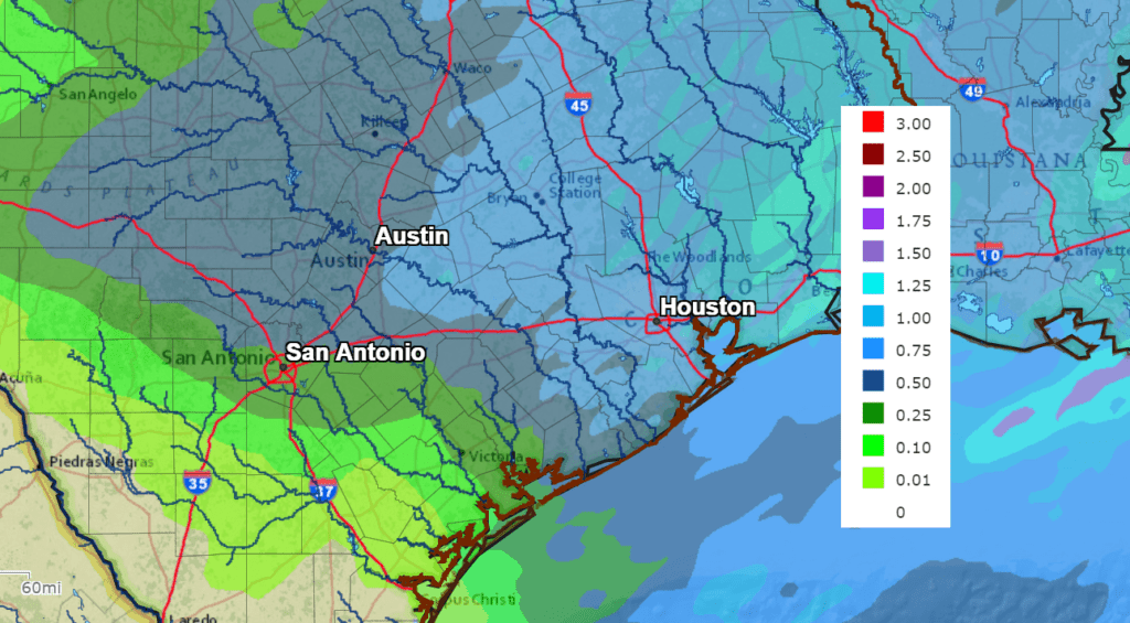
Rainfall amounts overnight and Wednesday morning are forecast to generally average between 0.5 and 1 inch. Isolated totals to near 2 inches will be possible.
NWS Rainfall Forecast for the Period 7 pm Tuesday through 7 pm Wednesday:
Clouds are forecast to clear, with the sky becoming sunny shortly behind the area of rain and thunderstorms. Breezy to windy conditions will develop as a large area of high pressure builds in behind the cold front.
For the Hill Country and Central Texas regions, expect northwesterly winds with speeds of 15-25 mph, with occasional to 35 mph developing Wednesday morning through Wednesday afternoon. Wind speeds of 10-15 mph with gusts to 30 mph are forecast Wednesday night. For the coastal region, expect west to northwesterly winds of 10-20 mph to develop Wednesday afternoon, continuing Wednesday night.
Northwesterly winds at 15-25 mph with gusts to 35 mph are forecast Thursday. Wind speeds should decrease to 10-15 mph Thursday night through Friday.
Sunny, dry and fall-like weather is forecast Thursday through Sunday.
Bob
Social Media