Quiet and dry weather conditions are in place as we close out the workweek. Canadian high pressure which brought us this week’s cool, fall-like temperatures, has shifted to the East Coast and the eastern Gulf of Mexico. South and southwesterly breezes on the back side of the high pressure system have now set up across Texas. These breezes will bring warmer and more humid conditions to our area beginning this afternoon, continuing through the weekend. Meanwhile, a weak ridge of high pressure in the mid and upper atmosphere covering the south central U.S. is expected to keep our weather sunny, dry, and stable through Sunday.
A developing surface trough of low pressure along the lee-side of the Rockies will be strengthening the pressure gradient across Texas as we move through the weekend. As a result, breezy conditions are forecast. Expect southerly winds at 10-20 mph, with occasional gusts to 25 mph this afternoon through Saturday. Gusts to near 30 mph can be expected on Sunday.
- High temperatures Friday afternoon through Sunday are forecast to generally be in the upper 80s. A few spots across Central Texas, including Austin, may reach 90 degrees.
- Lows Saturday morning are forecast to be around 60 degrees across the Hill Country, and in the low 60s at most other locations.
- Lows Sunday morning will range from the low 60s across the Hill Country, to the upper 60s across the coastal plains.
- Lows Monday morning will range from the upper 60s across the Hill Country, to the low 70s across the coastal plains.
A more unsettled weather pattern will begin taking shape Monday when a couple of features make a move toward Texas. The first feature will be a large trough of low pressure in the upper atmosphere tracking east out of the Rockies. The trough will help push a cold front southeast across the state. Forecasts call for the front to reach West Texas Monday night, the Interstate 35 corridor around sunrise Tuesday, and the middle Texas coast Tuesday afternoon. The second feature to influence our weather early next week will be the remnants of Tropical Storm Roslyn. Forecasts call for Roslyn to make landfall along the west coast of Mexico early Sunday, with the storm dissipating over the mountains of Mexico Sunday afternoon and Sunday night. However, some of the remnant middle and high-level moisture from Roslyn is forecast to get pulled northeast from Mexico and across Texas Monday into Tuesday, and will enhance our chance for rain.
Expect the sky to become mostly cloudy Sunday night and remain mostly cloudy throughout Monday. Scattered rain showers and isolated thunderstorms are forecast to develop Monday afternoon and continue through Monday night as moisture increases off the Gulf and the Pacific. The probability for rain will be at 50 percent. Note the most favorable period for rain and thunderstorms looks to occur late Monday night into early Tuesday morning (70 percent) when the cold front pushes southeast through the area. Based on the latest forecast data, the chance for strong to severe storms during this period appears to be fairly low. The chance for rain should diminish from west to east Tuesday morning into early Tuesday afternoon as drier and more stable air spreads in behind the cold front.
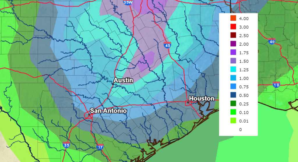
Rain amounts between Monday morning and Tuesday afternoon are forecast to generally average between 0.5 and 1 for the eastern Hill Country, most of Central Texas, and most of the coastal plains. Totals of 0.25-0.5 inches are forecast for the western Hill Country and the area adjacent to the coast.
NWS Rainfall Forecast for the Period 7 pm Friday through 7 pm Wednesday:
Sunny and slightly cooler weather will follow the cold front beginning Tuesday afternoon, continuing through next Thursday.
- High temperatures in the low 80s Monday, will cool to the upper 70s Tuesday through Thursday.
- Lows Tuesday morning will range from the mid-50s across the Hill Country, to the mid-60s towards the coast.
- Lows Wednesday and Thursday mornings will include the upper 40s across the Hill Country, the low 50s across Central Texas, and the mid-50s towards the coast.
Another chance for rain and thunderstorms is forecast for next Friday and Friday night when a trough of low pressure dips southeast out of the southern Rockies and tracks across North Texas. This fast-moving system is predicted to produce scattered showers and thunderstorms across the region Friday, with the rain tapering off Friday night. Rain amounts of 0.25-0.5 inches are forecast. Dry and slightly cooler weather looks to follow next weekend and into next Monday. Expect high temperatures around 80-82 degrees and lows in the 50s.
An early, early, look at Halloween weather calls for a mostly cloudy sky, with temperatures in the 70s and 60s that Monday evening.
Tropical Weather Update
National Hurricane Center forecasters are monitoring a small non-tropical area of low pressure located more than 1400 miles east of Bermuda. While this system is currently only producing limited shower activity and environmental conditions are only marginally favorable, recent satellite wind data indicates it has maximum sustained winds near 40 mph. This low is forecast to move quickly westward at 20-25 mph across the subtropical Atlantic towards warmer waters, and could acquire some subtropical or tropical characteristics by early next week. NHC forecasters give this system just a 20 percent chance for tropical development over the next 5 days.
There are no other systems in place which pose a threat for tropical development over the next 5 days.
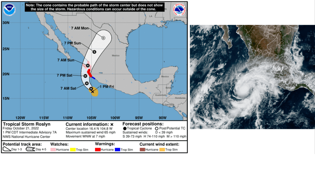
In the eastern tropical Pacific, forecasters continue to closely monitor the progress of Tropical Storm Roslyn.
As of 1 pm CDT Friday, the center of Tropical Storm Roslyn was located just south of the southern coast of Mexico, about 190 miles to the south of Manzanillo. Roslyn was moving toward the west-northwest near 7 mph, and this general motion is expected to continue through Friday. A turn toward the northwest and north-northwest is forecast Friday night and Saturday, followed by a northward and then north-northeastward motion Saturday night and Sunday. On the forecast track, the center of Roslyn will move parallel to the southwestern coast of Mexico Friday and Friday night, then approach the coast of west-central Mexico, making landfall along this coastline Saturday night or Sunday. Maximum sustained winds were near 65 mph with higher gusts. While Roslyn has changed little in strength over the past several hours, rapid strengthening is forecast during the next day or so, and Roslyn is expected to become a hurricane Friday night. Roslyn is expected to still be a hurricane when it reaches the coast of west-central Mexico on Sunday.
The First Election Day Total Lunar Eclipse in US History
A total eclipse of the moon will fall on the upcoming Election Day, Tuesday, November 8, 2022. Interestingly, looking back through historical records, this will be First Election Day total lunar eclipse in US history. And it won’t happen again until November 8, 2394! Records do show there was Election Day lunar eclipse on November 3, 1846, but the eclipse wasn’t total. Instead, it was a rather shallow penumbral lunar eclipse, in which the full moon completely missed the Earth’s inner, dark shadow. In other words, this penumbral eclipse of the full moon on Election Day 1846 wasn’t noticeable to the eye.
This November’s Election Day will be a total lunar eclipse and definitely visible to the unaided eye! Across North America, the full moon will pass through Earth’s dark shadow in the wee hours before sunrise on November 8th. The eclipse will reach totality between 4:16 and 5:41 am CST. (Courtesy Earthsky.org)
Have a good weekend!
Bob
Social Media