It is shaping up to be another unseasonably warm and dry week across the Hill Country, Central and South Texas. A broad ridge of high pressure in the upper atmosphere stretching from the Desert Southwest to the Middle-Atlantic States is forecast to remain in place through late week, keeping the cool air up to the north. Meanwhile at the surface, a moderate onshore flow off the Gulf of Mexico will continue pulling warm, moist Gulf air inland throughout the week, making it feel like late summer. No rain is predicted across the Hill Country or Central Texas regions this week. Previous forecasts had indicated a few showers might be possible as atmospheric moisture levels increased. However, high-resolution data now indicates the atmosphere will be too stable to support rain.
A weak cold front slipped south through much of the Hill Country Monday morning, bringing in cooler air. However, with little support from the middle and upper atmosphere, the front is already returning north as a warm front. Expect a partly cloudy sky across the entire region this afternoon. High temperatures will range from the mid-70s across the northern Hill Country to the mid and upper 80s at most other locations. Lows Tuesday morning will be in the mid and upper 60s.
Tuesday through Thursday, few changes in the weather are expected. Each day will feature widespread morning clouds followed by a mostly sunny to partly cloudy sky in the afternoon. Daily high temperatures will be in the mid and upper 80s while low temperatures will be in the mid and upper 60s. There will be a slight chance for a few scattered afternoon showers and isolated thunderstorms across the coastal plains region each day this week. However, rain amounts should be quite low.
A change in the weather is forecast to take place Friday afternoon into Friday evening when a Canadian cold front pushes south out of North Texas. No rain is predicted along or behind the front. Temperatures will warm in to the mid and upper 80s ahead of the front but trend noticeably cooler Friday night. Lows Saturday morning will include the low 50s across the Hill Country, the mid and upper 50s across Central Texas and the low to mid-60s towards the coast.
Sunny weather and pleasant temperatures are forecast this coming weekend. High temperatures will be in the upper 70s to low 80s. Low temperatures Sunday morning will be in mid-50s west to the mid-60s near the coast.
Monday’s data indicates big changes in the temperature will take place early next week when a strong cold front blasts through the area. Forecasts call for the front track across the region Monday with a few rain showers and isolated thunderstorms accompanying the cold front. However, rain amounts should stay below a quarter inch. Sunny, dry and much cooler weather will follow the front beginning Tuesday afternoon, continuing through late week. High temperatures Tuesday and Wednesday will be in the low 70s, warming to the mid-70s for the latter half of the week. Lows Tuesday and Wednesday mornings will be well in the 30s and 40s across the Hill Country and in the 50s across Central Texas and the coastal plains regions.
Aside from the chance for rain with next Monday’s cold front, dry weather is predicted for the remainder of next week.
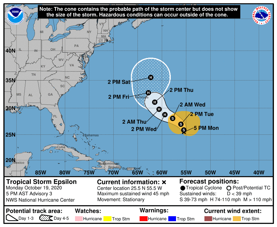
Tropical Weather Outlook
The broad area of low pressure which has been meandering across the central Atlantic since late last week strengthen to become Tropical Storm Epsilon Monday morning—the 26th named storm of the Atlantic Hurricane Season. Epsilon’s October 19 arrival marks the earliest date that any Atlantic season has produced its 26th named storm, surpassing the record held by Delta from November 22, 2005. In total, 23 of the 26 2020 named storms have set records for being the earliest-arriving for their respective letter; only Arthur, Bertha, and Dolly fell short.
As of 4 pm CDT, the center of Tropical Storm Epsilon was located roughly 730 miles southeast of Bermuda. Epsilon was nearly stationary. A slow northward motion is expected Monday night, followed by a northwestward or west-northwestward motion with an increase in forward speed through midweek. On the forecast track, Epsilon is expected to threaten Bermuda as a category 1 hurricane on Friday, but it will not be a landfall threat for the U.S.
Maximum sustained winds were near 45 mph with higher gusts. Gradual strengthening is expected during the next couple of days, and Epsilon is forecast to be at or near hurricane strength on Wednesday.

Have a good week.
Bob
Social Media