…Bitter cold arctic continues across the region…
…Freezing rain forecast to develop across most of the region tonight into early Wednesday with accumulations of ice expected…
…Travel conditions will deteriorate this evening into Wednesday morning…
…A Winter Storm Warning will be in effect from 600 pm Tuesday evening through 6 am Thursday…
Bitterly cold temperatures continue across the region. Readings early this morning were the coldest our area has seen in about 30 years. According to LCRA’s Hydromet, low temperatures were generally between zero and 5 degrees across the Hill Country, between 2 and 8 degrees across Central Texas and between 10 and 15 degrees across the middle Texas coast. A few sub-zero readings were noted across parts of the Hill Country. The coldest observed readings were a -6 and a-7 at a couple of gauges located just south of Abilene.
In Austin, Camp Mabry recorded a low temperatures of 7 degrees while Austin-Bergstrom recorded a low temperature of 8 degrees.
Sunny but very cold weather is in place across the region on this Tuesday. Light southeasterly breezes have returned and temperatures this afternoon will trend a little warmer. High temperatures are forecast to be in the mid and upper 20s across the Hill Country and Central Texas regions and into to the low 30s towards the coast.
Out next winter storm was located Tuesday morning over southern New Mexico. This trough of low pressure is forecast to Track east across the northern third of Texas tonight, then exit to the northeast Wednesday afternoon. Clouds will increase and the sky will become cloudy late afternoon into this evening. Light snow and sleet is forecast to develop across parts of West Texas this evening and continue overnight. Across the Hill Country and Central Texas regions, light freezing rain is forecast to develop near midnight and continue untill just after daybreak Wednesday. Across the coastal plains region, light showers mixed with freezing rain are forecast this evening, continuing through late morning Wednesday. The heaviest precipitation is expected to occur generally over the area that is along and east of Interstate 35. Lows Wednesday morning are forecast to be near 20 degrees across the Hill Country, in the mid to upper 20s across Central Texas and the coastal plains.
Freezing rain accumulations are forecast to be just a few hundredths of an inch across the Hill Country. For area areas along and east of Interstate 35, an ice accumulation of 0.1 inch up to a quarter inch is predicted. For the coastal plains region, very low ice accumulations are expected as temperatures are predicted to rise above freezing late tonight.
The precipitation is forecast to end from west to east early Wednesday morning, followed by a mostly cloudy sky and dry weather Wednesday afternoon. High temperatures are forecast to be in the mid and upper 30s, with lower 40s expected towards the coast.
One final wave of low pressure is forecast to move across the region Wednesday night into early Thursday morning. Another push of arctic air is forecast to move through the region at the same time. With only limited moisture in place, this system is forecast to produce just a slight chance for some snow or sleet—generally after midnight. No significant accumulation is forecast. The temperature will trend colder, with lows Thursday morning ranging from the upper teens across the Hill Country to the low and mid-20s across Central Texas to around 30 degrees near the coast.
Sunny, breezy and cold weather is forecast Thursday. High temperatures will generally be in the mid and upper 30s. Lows Friday morning will include the mid-teens across the Hill Country, between 15 and 20 degrees across Central Texas and in the mid-20s towards the coast.
Sunny and warmer weather looks to develop Friday as the arctic air mass begins shifting off to the east. Look for high temperatures to be in the mid and upper 40s. Lows Saturday morning will still be quite cold with lows mostly in the mid and upper 20s.
Mostly sunny and a little warmer weather can be expected this weekend, with high temperatures rising into the mid-50s Saturday and into the low 60s on Sunday. Low temperatures are forecast to be mostly in the upper 30s to low 40s.
Mild temperatures are expected to continue through all of next week.
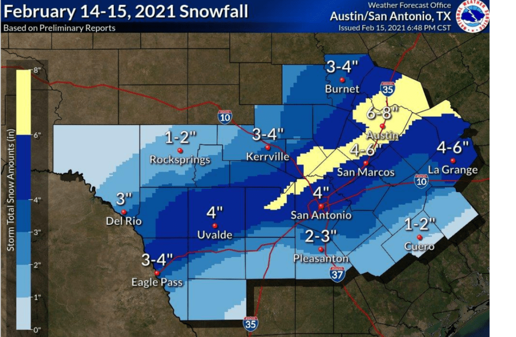
Preliminary Snowfall Total Graphic
The Austin/San Antonio National Weather Service office put together the following graphic of snow totals from the snow storm Sunday night into Monday morning. This graphic is based on reports relayed to the office by various observers.
Bob
Social Media