The trough of low pressure responsible for Monday’s rain has moved off to the east. As a result, dry weather will be in place this afternoon and tonight.
Attention now turns to mid and late week as numerous weather changes will be taking place. A trough of low pressure tracking east out of northern Mexico and the Desert Southwest is forecast to cause the development of light to moderate rain showers and a few isolated thunderstorms across the region Wednesday morning through Wednesday afternoon. Meanwhile, a strong arctic cold front is sill on track to push through our area Wednesday afternoon into Wednesday night. Forecasts call for the front to reach the northern Hill Country early Wednesday afternoon, the Austin area, around sunset and the middle Texas coast after midnight Wednesday night. Windy and much colder weather will develop behind the cold front Wednesday night. Expect northerly winds of 15-20 mph, with gusts to 30 mph. Readings are predicted to fall below freezing across the Hill Country and the Austin/Interstate 35 corridor by sunrise Thursday.
- Lows Thursday morning are forecast to be in the low 20s across the Hill Country, be around 30 degrees in the Austin area, in the low and mid-30s across Central Texas and around 40 degrees across the coastal plains.
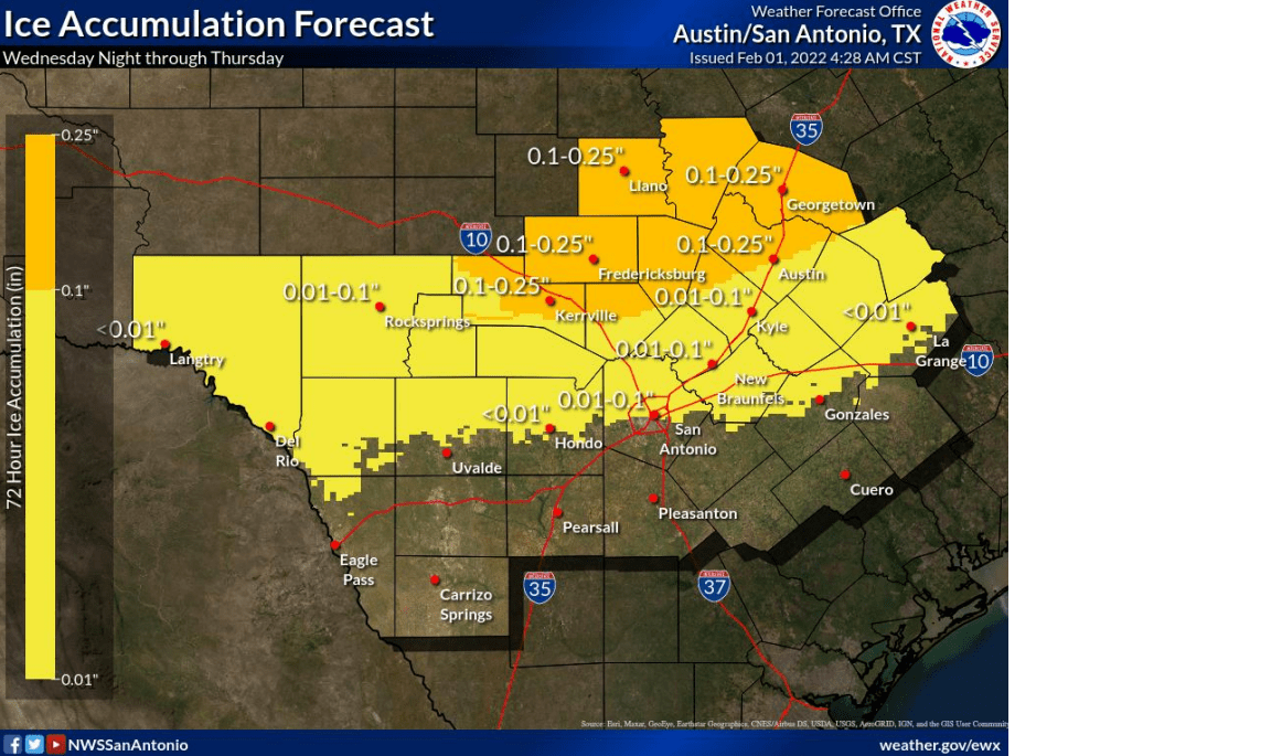
With the trough to our west, light precipitation is forecast to continue across the region Wednesday night through Thursday afternoon. Initially, the precipitation is expected to be a cold rain Wednesday evening and Wednesday night. But as temperatures fall below freezing late Wednesday night and toward daybreak Thursday across the Hill Country and the Austin/Interstate 35 corridor, wintery precipitation is forecast to develop. Freezing rain and sleet appear to be the primary winter weather types, although parts of the western and northern Hill Country could see some light snow. Based on the most recent forecast model solutions, there is now medium to high confidence for freezing rain and sleet to occur across these two areas Thursday morning into Thursday afternoon. This precipitation may cause icing amounts that will impact travel through the Hill Country and the Austin metro beginning Thursday morning. Travel could be very difficult on untreated roads, especially elevated bridges, overpasses, and roadways, across the Hill Country and Austin metro area Thursday.
With the upcoming threat for icy conditions, the National Weather Service has posted a Winter Storm Watch for all of the Hill Country, plus the Austin area and the I-35 corridor between Georgetown and San Marcos, from 3 am till 6 pm Thursday. Preliminary indications point toward potential ice accumulations of 1/10 to 1/4 of an inch in the watch area. Across the Big Country and northern Hill Country, ice and sleet accumulations of a quarter to a half inch are forecast.
Do note rain, rain, freezing rain and sleet are also forecast for the area east of Interstate 35, generally to the north of a line stretching from San Antonio to La Grange. However, surface temperatures are predicted to be just above freezing, so impacts shouldn’t be quite as great as for areas further to the west. This situation is still evolving and greater impacts could possibly affect these parts of Central Texas as well. As of now, no wintery precipitation is forecast across the middle Texas coast.
All of the precipitation is predicted to end from west to east late Thursday afternoon into early Thursday evening.
Thursday’s weather is forecast to be quite cold and windy. High temperatures will include the mid and upper 20s across the Hill Country, around 30-32 degrees in Austin, in the low and mid-30s across Central Texas and the mid to upper 30s across the coastal plains. Strong north winds of 10-20 mph with gusts to 30 mph will cause wind chill temperatures in the teens.
Mostly sunny, dry and cold weather is predicted Thursday night through Sunday. Friday and Saturday mornings will be the coldest point of this cold outbreak. Overall, the temperature forecast hasn’t changed significantly since my Monday report.
- Low temperatures Friday and Saturday mornings near 10-15 degrees across the Hill Country, near 20 degrees Austin area, upper teens to low 20s Central Texas and mid-20s coastal region.
- High temperatures Friday mid and upper 30s and near 40 near the coast.
- High temperatures Saturday around 40 degrees.
- Lows Sunday morning low 20s Hill Country, mid and upper 20s Central Texas area, and near 30 degrees coastal region.
- High temperatures Sunday in the low 50s.
- Lows Monday morning ranging from the low 20s Hill Country, to the low 30s near the coast.
In getting ready for the cold outbreak, please remember the 4 P`s and protect sensitive People, Pets, Plants, and Pipes.
Bob
Social Media